


Create successful ePaper yourself
Turn your PDF publications into a flip-book with our unique Google optimized e-Paper software.
100 Chapter 6: Middleton Fell<br />
<strong>The</strong> <strong>Lune</strong> from Stockdale Beck ...<br />
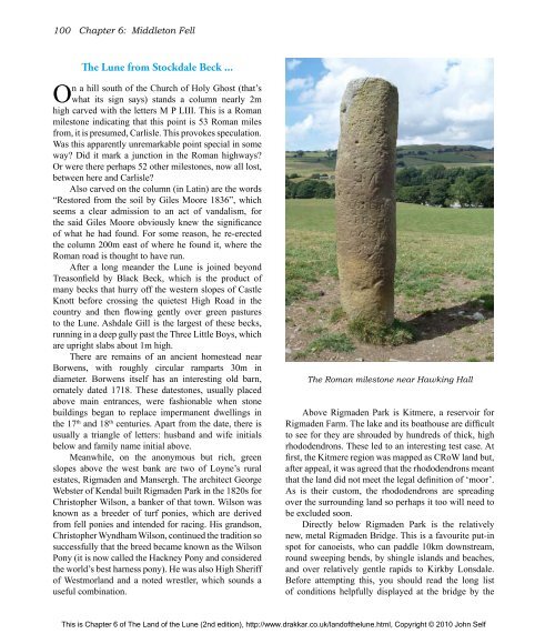
On a hill south <strong>of</strong> <strong>the</strong> Church <strong>of</strong> Holy Ghost (that’s<br />
what its sign says) stands a column nearly 2m<br />
high carved with <strong>the</strong> letters M P LIII. This is a Roman<br />
milestone indicating that this point is 53 Roman miles<br />
from, it is presumed, Carlisle. This provokes speculation.<br />
Was this apparently unremarkable point special in some<br />
way? Did it mark a junction in <strong>the</strong> Roman highways?<br />
Or were <strong>the</strong>re perhaps 52 o<strong>the</strong>r milestones, now all lost,<br />
between here and Carlisle?<br />
Also carved on <strong>the</strong> column (in Latin) are <strong>the</strong> words<br />
“Restored from <strong>the</strong> soil by Giles Moore 1836”, which<br />
seems a clear admission to an act <strong>of</strong> vandalism, for<br />
<strong>the</strong> said Giles Moore obviously knew <strong>the</strong> significance<br />
<strong>of</strong> what he had found. For some reason, he re-erected<br />
<strong>the</strong> column 200m east <strong>of</strong> where he found it, where <strong>the</strong><br />
Roman road is thought to have run.<br />
After a long meander <strong>the</strong> <strong>Lune</strong> is joined beyond<br />
Treasonfield by Black Beck, which is <strong>the</strong> product <strong>of</strong><br />
many becks that hurry <strong>of</strong>f <strong>the</strong> western slopes <strong>of</strong> Castle<br />
Knott before crossing <strong>the</strong> quietest High Road in <strong>the</strong><br />
country and <strong>the</strong>n flowing gently over green pastures<br />
to <strong>the</strong> <strong>Lune</strong>. Ashdale Gill is <strong>the</strong> largest <strong>of</strong> <strong>the</strong>se becks,<br />
running in a deep gully past <strong>the</strong> Three Little Boys, which<br />
are upright slabs about 1m high.<br />
<strong>The</strong>re are remains <strong>of</strong> an ancient homestead near<br />
Borwens, with roughly circular ramparts 30m in<br />
diameter. Borwens itself has an interesting old barn,<br />
ornately dated 1718. <strong>The</strong>se datestones, usually placed<br />
above main entrances, were fashionable when stone<br />
buildings began to replace impermanent dwellings in<br />
<strong>the</strong> 17th and 18th centuries. Apart from <strong>the</strong> date, <strong>the</strong>re is<br />
usually a triangle <strong>of</strong> letters: husband and wife initials<br />
below and family name initial above.<br />
Meanwhile, on <strong>the</strong> anonymous but rich, green<br />
slopes above <strong>the</strong> west bank are two <strong>of</strong> Loyne’s rural<br />
estates, Rigmaden and Mansergh. <strong>The</strong> architect George<br />
Webster <strong>of</strong> Kendal built Rigmaden Park in <strong>the</strong> 1820s for<br />
Christopher Wilson, a banker <strong>of</strong> that town. Wilson was<br />
known as a breeder <strong>of</strong> turf ponies, which are derived<br />
from fell ponies and intended for racing. His grandson,<br />
Christopher Wyndham Wilson, continued <strong>the</strong> tradition so<br />
successfully that <strong>the</strong> breed became known as <strong>the</strong> Wilson<br />
Pony (it is now called <strong>the</strong> Hackney Pony and considered<br />
<strong>the</strong> world’s best harness pony). He was also High Sheriff<br />
<strong>of</strong> Westmorland and a noted wrestler, which sounds a<br />
useful combination.<br />
<strong>The</strong> Roman milestone near Hawking Hall<br />
Above Rigmaden Park is Kitmere, a reservoir for<br />
Rigmaden Farm. <strong>The</strong> lake and its boathouse are difficult<br />
to see for <strong>the</strong>y are shrouded by hundreds <strong>of</strong> thick, high<br />
rhododendrons. <strong>The</strong>se led to an interesting test case. At<br />
first, <strong>the</strong> Kitmere region was mapped as CRoW land but,<br />
after appeal, it was agreed that <strong>the</strong> rhododendrons meant<br />
that <strong>the</strong> land did not meet <strong>the</strong> legal definition <strong>of</strong> ‘moor’.<br />
As is <strong>the</strong>ir custom, <strong>the</strong> rhododendrons are spreading<br />
over <strong>the</strong> surrounding land so perhaps it too will need to<br />
be excluded soon.<br />
Directly below Rigmaden Park is <strong>the</strong> relatively<br />
new, metal Rigmaden Bridge. This is a favourite put-in<br />
spot for canoeists, who can paddle 10km downstream,<br />
round sweeping bends, by shingle islands and beaches,<br />
and over relatively gentle rapids to Kirkby Lonsdale.<br />
Before attempting this, you should read <strong>the</strong> long list<br />
<strong>of</strong> conditions helpfully displayed at <strong>the</strong> bridge by <strong>the</strong><br />
This is Chapter 6 <strong>of</strong> <strong>The</strong> <strong>Land</strong> <strong>of</strong> <strong>the</strong> <strong>Lune</strong> (2nd edition), http://www.drakkar.co.uk/land<strong>of</strong><strong>the</strong>lune.html, Copyright © 2010 John Self

