


Create successful ePaper yourself
Turn your PDF publications into a flip-book with our unique Google optimized e-Paper software.
Reflections from <strong>the</strong> Point <strong>of</strong> <strong>Lune</strong><br />
And so, at <strong>the</strong> Point <strong>of</strong> <strong>Lune</strong>, <strong>the</strong> waters <strong>of</strong> <strong>the</strong> <strong>Lune</strong><br />
and all its tributaries finally merge into Morecambe<br />
Bay and <strong>the</strong> Irish Sea. <strong>The</strong> final sentence <strong>of</strong> Return to <strong>the</strong><br />
<strong>Lune</strong> Valley (2002) concludes that a tour down <strong>the</strong> <strong>Lune</strong><br />
valley is “an interesting journey and a pleasant one”.<br />
‘Pleasant’ is perhaps as positive as one can be about <strong>the</strong><br />
<strong>Lune</strong> valley itself but it is possible to support a claim<br />
that <strong>the</strong> wider area within <strong>the</strong> <strong>Lune</strong> watershed is <strong>the</strong> most<br />
varied <strong>of</strong> any river in England.<br />
Natural England has produced an analysis <strong>of</strong><br />
England in terms <strong>of</strong> 159 ‘National Character Areas’,<br />
that is, areas that are “distinctive with a unique ‘sense <strong>of</strong><br />
place’”. <strong>The</strong> Loyne region includes parts <strong>of</strong> ten <strong>of</strong> <strong>the</strong>se<br />
National Character Areas. No o<strong>the</strong>r English river <strong>of</strong> <strong>the</strong><br />
size <strong>of</strong> <strong>the</strong> <strong>Lune</strong> and its tributaries, if any at all, passes<br />
through so many Character Areas. In <strong>the</strong> following<br />
review <strong>of</strong> our journey, <strong>the</strong> Character Areas are indicated<br />
in italics.<br />
<strong>The</strong> River <strong>Lune</strong> rises in <strong>the</strong> Howgills, which are<br />
composed <strong>of</strong> ancient sedimentary rocks that have been<br />
eroded into steep, rounded, grassy hills, incised by swiftflowing<br />
becks and grazed by sheep, but largely devoid <strong>of</strong><br />
people. As <strong>the</strong> <strong>Lune</strong> swings west, on its nor<strong>the</strong>rn side are<br />
<strong>the</strong> Orton Fells, composed <strong>of</strong> limestone. Below dramatic<br />
limestone pavements, <strong>the</strong>re is fertile soil supporting<br />
improved pasture.<br />
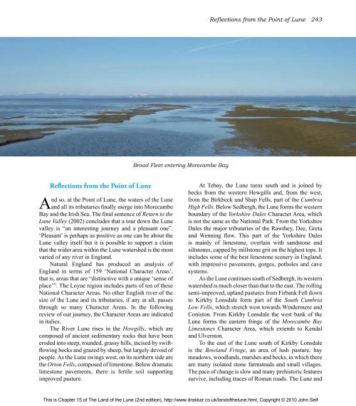
Broad Fleet entering Morecambe Bay<br />
Reflections from <strong>the</strong> Point <strong>of</strong> <strong>Lune</strong> 243<br />
At Tebay, <strong>the</strong> <strong>Lune</strong> turns south and is joined by<br />
becks from <strong>the</strong> western Howgills and, from <strong>the</strong> west,<br />
from <strong>the</strong> Birkbeck and Shap Fells, part <strong>of</strong> <strong>the</strong> Cumbria<br />
High Fells. Below Sedbergh, <strong>the</strong> <strong>Lune</strong> forms <strong>the</strong> western<br />
boundary <strong>of</strong> <strong>the</strong> Yorkshire Dales Character Area, which<br />
is not <strong>the</strong> same as <strong>the</strong> National Park. From <strong>the</strong> Yorkshire<br />
Dales <strong>the</strong> major tributaries <strong>of</strong> <strong>the</strong> Raw<strong>the</strong>y, Dee, Greta<br />
and Wenning flow. This part <strong>of</strong> <strong>the</strong> Yorkshire Dales<br />
is mainly <strong>of</strong> limestone, overlain with sandstone and<br />
siltstones, capped by millstone grit on <strong>the</strong> highest tops. It<br />
includes some <strong>of</strong> <strong>the</strong> best limestone scenery in England,<br />
with impressive pavements, gorges, potholes and cave<br />
systems.<br />
As <strong>the</strong> <strong>Lune</strong> continues south <strong>of</strong> Sedbergh, its western<br />
watershed is much closer than that to <strong>the</strong> east. <strong>The</strong> rolling<br />
semi-improved, upland pastures from Firbank Fell down<br />
to Kirkby Lonsdale form part <strong>of</strong> <strong>the</strong> South Cumbria<br />
Low Fells, which stretch west towards Windermere and<br />
Coniston. From Kirkby Lonsdale <strong>the</strong> west bank <strong>of</strong> <strong>the</strong><br />
<strong>Lune</strong> forms <strong>the</strong> eastern fringe <strong>of</strong> <strong>the</strong> Morecambe Bay<br />
Limestones Character Area, which extends to Kendal<br />
and Ulverston.<br />
To <strong>the</strong> east <strong>of</strong> <strong>the</strong> <strong>Lune</strong> south <strong>of</strong> Kirkby Lonsdale<br />
is <strong>the</strong> Bowland Fringe, an area <strong>of</strong> lush pasture, hay<br />
meadows, woodlands, marshes and becks, in which <strong>the</strong>re<br />
are many isolated stone farmsteads and small villages.<br />
<strong>The</strong> pace <strong>of</strong> change is slow and many prehistoric features<br />
survive, including traces <strong>of</strong> Roman roads. <strong>The</strong> <strong>Lune</strong> and<br />
This is Chapter 15 <strong>of</strong> <strong>The</strong> <strong>Land</strong> <strong>of</strong> <strong>the</strong> <strong>Lune</strong> (2nd edition), http://www.drakkar.co.uk/land<strong>of</strong><strong>the</strong>lune.html, Copyright © 2010 John Self

