


Create successful ePaper yourself
Turn your PDF publications into a flip-book with our unique Google optimized e-Paper software.
<strong>The</strong> Greta from Kingsdale Beck<br />
Chapel Beck and Kingsdale Beck (or <strong>the</strong> Rivers<br />
Twiss and Doe, or vice versa) merge to form <strong>the</strong><br />
Greta in <strong>the</strong> middle <strong>of</strong> Ingleton. Ingleton is always<br />
thought <strong>of</strong> as part <strong>of</strong> <strong>the</strong> Yorkshire Dales although it is<br />
in fact carefully excluded from <strong>the</strong> National Park, whose<br />
boundary detours around <strong>the</strong> nor<strong>the</strong>rn outskirts. Perhaps<br />
<strong>the</strong> boundary makers agreed with <strong>the</strong> afore-mentioned<br />
Thos Johnson who, writing <strong>of</strong> <strong>the</strong> church in 1872, said<br />
that it “partakes <strong>of</strong> <strong>the</strong> character <strong>of</strong> <strong>the</strong> houses, being a<br />
miserable, slap-dashed building, without one redeeming<br />
feature.”<br />
No writer would dare to be so <strong>of</strong>fensive today but<br />
even so it cannot be denied that Ingleton has more <strong>of</strong><br />
an industrial nature than places we’ve visited earlier.<br />
Apart from <strong>the</strong> tourist industry, which dominates today,<br />
<strong>the</strong>re is still quarrying nearby, although on a lesser scale<br />
than previously, and an industrial estate, close to <strong>the</strong> site<br />
<strong>of</strong> <strong>the</strong> old Ingleton Colliery. In 2004 a monument was<br />
erected near <strong>the</strong> A65 to help ensure that Ingleton’s coal<br />
mining history is not forgotten. Small-scale coal mining,<br />
<strong>The</strong> Greta from Kingsdale Beck 141<br />
as in Dentdale and Barbondale, existed here since <strong>the</strong><br />
17 th century, although <strong>the</strong> seams were <strong>of</strong> poor quality<br />
and thin, as indicated by <strong>the</strong>ir being called <strong>the</strong> ‘four<br />
feet’ and ‘six feet’ seams. Numerous pits are shown on<br />
<strong>the</strong> OS map, all marked as disused, which <strong>the</strong>y became<br />
once <strong>the</strong> railways made local coal mining uneconomic.<br />
In 1913, however, a ‘ten feet’ seam was found deeper<br />
underground (quite why anyone went to <strong>the</strong> trouble <strong>of</strong><br />
looking is unclear). <strong>The</strong> Ingleton Colliery operated until<br />
1936, employing up to 900 people. <strong>The</strong>re is no sign <strong>of</strong><br />
<strong>the</strong> colliery now but it is not inconceivable that, with<br />
new technologies and changing energy policies, coal<br />
mining will return to <strong>the</strong> region.<br />
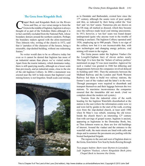
<strong>The</strong> Greta passes under <strong>the</strong> Ingleton Viaduct (for<br />
<strong>the</strong> Lowgill-Clapham line) <strong>of</strong> eleven arches nearly<br />
30m high. It is here that <strong>the</strong> ‘failure <strong>of</strong> railway politics’<br />
mentioned on page 52 was most manifest. Approval for<br />
such a viaduct was granted in 1846 but di<strong>the</strong>ring and<br />
disagreements between <strong>the</strong> companies involved delayed<br />
its building until 1861. <strong>The</strong>n <strong>the</strong> animosity between <strong>the</strong><br />
Midland Railway and <strong>the</strong> London and North Western<br />
Railway led <strong>the</strong>m to build two railway stations, <strong>the</strong><br />
former’s east <strong>of</strong> <strong>the</strong> viaduct and <strong>the</strong> latter’s to <strong>the</strong> west.<br />
Through passengers were required to disembark and<br />
transport <strong>the</strong>mselves and <strong>the</strong>ir luggage between <strong>the</strong> two<br />
stations. To maximise inconvenience <strong>the</strong> companies<br />
ensured that <strong>the</strong> timetables did not mesh. (And we<br />
complain about <strong>the</strong> modern rail system.)<br />
Tourists from <strong>the</strong> industrial cities <strong>of</strong> <strong>the</strong> north<br />
heading for <strong>the</strong> Ingleton Waterfalls disembarked at <strong>the</strong><br />
station to <strong>the</strong> east (where <strong>the</strong> information centre now is)<br />
and were led by guides to <strong>the</strong> start <strong>of</strong> <strong>the</strong> walk, averting<br />
eyes from <strong>the</strong> slap-dashed church, at least until 1886<br />
when St Mary’s was rebuilt, retaining <strong>the</strong> old tower.<br />
Inside <strong>the</strong> church <strong>the</strong>re’s an interesting 12 th century<br />
font with carvings <strong>of</strong> gospel scenes. Ingleton is ancient,<br />
appearing as Inglestune in <strong>the</strong> Domesday Book, but,<br />
as Thos Johnson warns us, <strong>the</strong>re are few old buildings<br />
<strong>of</strong> interest. Around <strong>the</strong> viaduct and <strong>the</strong> entrance to <strong>the</strong><br />
waterfall walk, <strong>the</strong> main streets are lined with cafés and<br />
shops and in summer <strong>the</strong> pavements are jostling with <strong>the</strong><br />
booted backpacked brigade.<br />
<strong>The</strong> regions to <strong>the</strong> east and west <strong>of</strong> Ingleton drain to<br />
<strong>the</strong> Greta, from below Tow Scar by becks flowing through<br />
Two pages before: Barn near Burton-in-Lonsdale.<br />
Left: Ingleton Viaduct, where Kingsdale Beck joins<br />
Chapel Beck to become <strong>the</strong> Greta.<br />
This is Chapter 9 <strong>of</strong> <strong>The</strong> <strong>Land</strong> <strong>of</strong> <strong>the</strong> <strong>Lune</strong> (2nd edition), http://www.drakkar.co.uk/land<strong>of</strong><strong>the</strong>lune.html, Copyright © 2010 John Self

