


You also want an ePaper? Increase the reach of your titles
YUMPU automatically turns print PDFs into web optimized ePapers that Google loves.
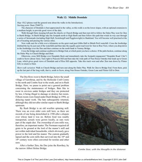
<strong>The</strong> Dee flows west to Barth Bridge, below <strong>the</strong> small<br />
village <strong>of</strong> Gawthrop, and by <strong>the</strong> Helmside Craft Centre<br />
to <strong>the</strong> north and Combe Scar to <strong>the</strong> south, and on to Rash<br />
Bridge. Here, we pause to point out a general problem<br />
concerning <strong>the</strong> maintenance <strong>of</strong> bridges. Bats like to<br />
roost in crevices under bridges and <strong>the</strong>y are protected<br />
by law, it being illegal to damage or destroy bat roosts.<br />
Fifteen roosts were found under Rash Bridge in 1994, so<br />
delaying repair work. <strong>The</strong> bats subsequently returned,<br />
although <strong>the</strong>y did not after similar repair to Barth Bridge<br />
upstream.<br />
By Rash Bridge is an old woollen spinning mill.<br />
<strong>The</strong>re was an even older corn mill here, as <strong>the</strong>re are<br />
records <strong>of</strong> one being demolished in 1590 after a dispute<br />
over whose land it was on. Before food was readily<br />
transported, cereals were grown locally, as oats were<br />
part <strong>of</strong> <strong>the</strong> staple diet. <strong>The</strong> ownership <strong>of</strong> corn mills was,<br />
<strong>the</strong>refore, an important matter. <strong>The</strong> Normans required all<br />
grain to be ground at <strong>the</strong> lord <strong>of</strong> <strong>the</strong> manor’s mill and<br />
not within individual households, which obviously gave<br />
power to <strong>the</strong> lord and his manor. <strong>The</strong> custom gradually<br />
lapsed and <strong>the</strong> corn mills that survived into <strong>the</strong> 18 th and<br />
19 th century were <strong>of</strong>ten converted for textiles and o<strong>the</strong>r<br />
uses.<br />
After a fur<strong>the</strong>r 2km, <strong>the</strong> Dee joins <strong>the</strong> Raw<strong>the</strong>y, by<br />
<strong>the</strong> narrow Abbot Holme Bridge.<br />
Walk 12: Middle Dentdale<br />
<strong>The</strong> River Dee 89<br />
Map: OL2 (please read <strong>the</strong> general note about <strong>the</strong> walks in <strong>the</strong> Introduction).<br />
Starting point: Dent (704872).<br />
<strong>The</strong> character <strong>of</strong> Dentdale is best appreciated in <strong>the</strong> valley, so this walk is on <strong>the</strong> lower slopes, with an optional extension to<br />
a medium height, to provide good views <strong>of</strong> <strong>the</strong> dale.<br />
Walk through Dent, keeping left past <strong>the</strong> church, to Church Bridge and <strong>the</strong>n turn left to follow <strong>the</strong> Dales Way west for 2km<br />
to Barth Bridge. At Barth Bridge take <strong>the</strong> footpath north to High Barth and <strong>the</strong>n follow this path that winds its way east through<br />
a series <strong>of</strong> farmsteads (including High Hall, Scotchergill and Peggleswright) to Bankland. You will become well practised at <strong>the</strong><br />
art <strong>of</strong> locating and passing <strong>the</strong> various stiles.<br />
Now walk east for a little over a kilometre on <strong>the</strong> quiet road past Gibbs Hall to Ibbeth Peril waterfall. Cross <strong>the</strong> footbridge<br />
(behind <strong>the</strong> lay-by just east <strong>of</strong> <strong>the</strong> waterfall) and <strong>the</strong>n take <strong>the</strong> equally quiet road west for 1km to Rise View, where you drop down<br />
to <strong>the</strong> footbridge over <strong>the</strong> Dee and <strong>the</strong>n continue on <strong>the</strong> north bank to Tommy Bridge.<br />
Cross <strong>the</strong> bridge and continue southwest to Bridge End, at which point you have a choice. If <strong>the</strong> pubs beckon, continue along<br />
<strong>the</strong> Dales Way to Church Bridge and Dent.<br />
O<strong>the</strong>rwise, cross Mill Bridge over Deepdale Beck and immediately take <strong>the</strong> footpath (signposted “Deepdale Road 1/4m”)<br />
south to Scow (about 1km). Turn right to Peacock Hill and <strong>the</strong>n take <strong>the</strong> wide path <strong>of</strong> Nun House Outrake that leads up to Green<br />
Lane, which gives good views <strong>of</strong> Dentdale and <strong>of</strong> Rise Hill opposite. Take this track west and after 2km turn down by Flinter<br />
Gill, to return to Dent.<br />
Short walk variation: Walk to Church Bridge and turn east along <strong>the</strong> Dales Way. Walk for 2km to Bridge End. From <strong>the</strong>re, pick<br />
up <strong>the</strong> last part <strong>of</strong> <strong>the</strong> long walk, that is, south to Scow, along Nun House Outrake, Green Lane and Flinter Gill to Dent.<br />
Combe Scar, with <strong>the</strong> Howgills in <strong>the</strong> distance<br />
This is Chapter 5 <strong>of</strong> <strong>The</strong> <strong>Land</strong> <strong>of</strong> <strong>the</strong> <strong>Lune</strong> (2nd edition), http://www.drakkar.co.uk/land<strong>of</strong><strong>the</strong>lune.html, Copyright © 2010 John Self

