


You also want an ePaper? Increase the reach of your titles
YUMPU automatically turns print PDFs into web optimized ePapers that Google loves.
130 Chapter 8: <strong>The</strong> Greta Headwaters<br />
Ingleborough was <strong>of</strong>ten in <strong>the</strong> past <strong>the</strong> site <strong>of</strong> a beacon.<br />
<strong>The</strong> ‘borough’ (as we saw with Low Borrowbridge and<br />
Over Burrow) may be associated with an old fortification.<br />
In fact, <strong>the</strong> Ordnance Survey is bold enough to mark<br />
‘fort’ on its map. <strong>The</strong> fort is variously believed to have<br />
been built by <strong>the</strong> Romans, by <strong>the</strong> Brigantes (against <strong>the</strong><br />
Romans) and by pre-Roman Iron Age settlers. But David<br />
Johnson, in his 2008 book on Ingleborough, doubts that<br />
it was a fort at all. He does not consider that <strong>the</strong> remains<br />
<strong>of</strong> <strong>the</strong> wall, which some call ramparts, that run round<br />
<strong>the</strong> rim <strong>of</strong> <strong>the</strong> summit plateau are substantial enough to<br />
indicate any defensive role. Also, <strong>the</strong> lack <strong>of</strong> water on<br />
<strong>the</strong> plateau makes it an implausible defensive retreat.<br />
This fact also leads Johnson to doubt that <strong>the</strong> score<br />
or so <strong>of</strong> circular remains that can be seen on <strong>the</strong> plateau<br />
are those <strong>of</strong> hut circles, as is usually stated. Ancient<br />
people were hardy, but not necessarily masochistic, as<br />
<strong>the</strong>y would need to have been to choose to live here,<br />
completely exposed to <strong>the</strong> elements, <strong>of</strong> which <strong>the</strong>re<br />
are many on <strong>the</strong> top <strong>of</strong> Ingleborough. He considers <strong>the</strong><br />
remains to be those <strong>of</strong> ring cairns and that in ancient times<br />
<strong>the</strong> top <strong>of</strong> Ingleborough served symbolic or ceremonial<br />
functions ra<strong>the</strong>r than military or residential ones. Much<br />
like today, in fact.<br />
<strong>The</strong>se ancient remains should not be confused with<br />
<strong>the</strong> great pile <strong>of</strong> stones on <strong>the</strong> western rim. This was a<br />
hospice-cum-tower-cum-shooting-box. It was left to<br />
fall into ruin after damage was caused at a boisterous<br />
opening ceremony in 1830. Recalling this event in <strong>the</strong><br />
Lancaster Guardian in 1897, Joseph Carr described <strong>the</strong><br />
tower as “one <strong>of</strong> <strong>the</strong> wonders <strong>of</strong> <strong>Lune</strong>sdale” – note <strong>the</strong><br />
<strong>Lune</strong>sdale. Still standing is <strong>the</strong> cross-shaped wind shelter<br />
erected in 1953. This provides endless entertainment for,<br />
sitting in one quarter, one cannot help eavesdropping on<br />
conversations in <strong>the</strong> o<strong>the</strong>r three quarters. <strong>The</strong>se are <strong>of</strong>ten<br />
disputes over <strong>the</strong> identification <strong>of</strong> distant peaks. One<br />
can hardly intrude to point out <strong>the</strong> view indicator in <strong>the</strong><br />
middle <strong>of</strong> <strong>the</strong> cross.<br />
Ingleborough’s distinctive pr<strong>of</strong>ile is a consequence<br />
<strong>of</strong> its geology, which is similar to that <strong>of</strong> Whernside and<br />
Wild Boar Fell. <strong>The</strong> top 30m or so are <strong>of</strong> hardwearing<br />
millstone grit. This sits atop 250m <strong>of</strong> conglomerate rocks<br />
(<strong>the</strong> Yoredale series), mainly shales and sandstones, with<br />
a little limestone, all covered with peat except where<br />
exposed on <strong>the</strong> crags. Below this is a 200m layer <strong>of</strong><br />
limestone (<strong>the</strong> Great Scar limestone), which is visible<br />
on <strong>the</strong> lower slopes <strong>of</strong> <strong>the</strong> mountain. <strong>The</strong>se are all<br />
sedimentary rocks <strong>of</strong> <strong>the</strong> Carboniferous period that have<br />
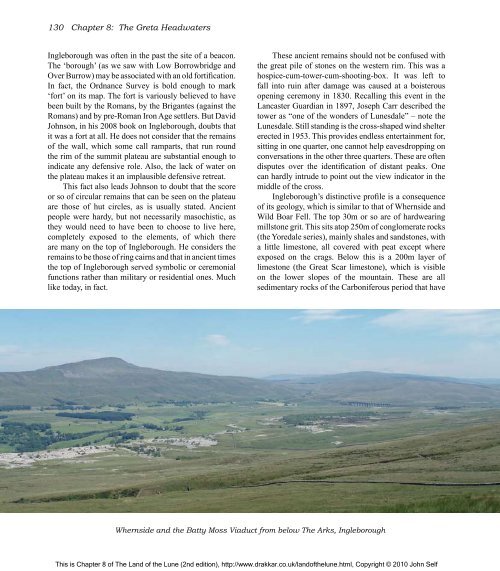
Whernside and <strong>the</strong> Batty Moss Viaduct from below <strong>The</strong> Arks, Ingleborough<br />
This is Chapter 8 <strong>of</strong> <strong>The</strong> <strong>Land</strong> <strong>of</strong> <strong>the</strong> <strong>Lune</strong> (2nd edition), http://www.drakkar.co.uk/land<strong>of</strong><strong>the</strong>lune.html, Copyright © 2010 John Self

