


Create successful ePaper yourself
Turn your PDF publications into a flip-book with our unique Google optimized e-Paper software.
<strong>The</strong> <strong>Lune</strong> from Bowderdale Beck ...<br />
<strong>The</strong> <strong>Lune</strong> runs due west, more due than it used to as<br />
it was straightened to run alongside <strong>the</strong> A685 when<br />
it was rebuilt on <strong>the</strong> line <strong>of</strong> <strong>the</strong> old Newbiggin-on-<strong>Lune</strong><br />
to Tebay railway after it closed in 1962. This seems an<br />
unnecessarily brutal way to treat <strong>the</strong> young <strong>Lune</strong>, just as<br />
it is making its way in <strong>the</strong> world.<br />
Becks, such as Flakebridge Beck and Cotegill Beck,<br />
continue to enter <strong>the</strong> <strong>Lune</strong> from <strong>the</strong> south but very little<br />
water flows from <strong>the</strong> north. <strong>The</strong> old limestone quarries<br />
and limekilns that are seen on <strong>the</strong> slopes between<br />
Potlands and Kelleth hint at <strong>the</strong> reason for <strong>the</strong> dryness <strong>of</strong><br />
<strong>the</strong> nor<strong>the</strong>rn slopes. Limekilns, which usually date from<br />
<strong>the</strong> 18th or 19th century, were used to burn limestone to<br />
make quicklime. This was <strong>the</strong>n slaked with water and<br />
used to reduce <strong>the</strong> acidity <strong>of</strong> pastures and also to limewash<br />
buildings. <strong>The</strong> limestone was tipped into <strong>the</strong><br />
kiln from <strong>the</strong> top onto a fire <strong>of</strong> coal or wood, and <strong>the</strong>n<br />
more coal and limestone layered on top. <strong>The</strong> open arch<br />
provided air to keep <strong>the</strong> fire going.<br />
<strong>The</strong> members <strong>of</strong> Kelleth Rigg’s herd <strong>of</strong> pedigree<br />
Blonde d’Aquitaine cattle look lime-washed too. Kelleth<br />
itself is a small village, recently enlarged by new building,<br />
aligned along <strong>the</strong> now quiet road by-passed by <strong>the</strong> A685.<br />
<strong>The</strong> <strong>Lune</strong> reaches <strong>the</strong> ra<strong>the</strong>r ornate Rayne Bridge, built<br />
<strong>of</strong> red sandstone. Well, <strong>the</strong> parapet and wall are <strong>of</strong> red<br />
sandstone – <strong>the</strong> bridge itself isn’t, as a side view from<br />
<strong>the</strong> east reveals. <strong>The</strong> bridge was built in 1903 to replace<br />
one that required an abrupt turn on <strong>the</strong> road. Soon after<br />
Rayne Bridge, Langdale Beck joins <strong>the</strong> <strong>Lune</strong>.<br />
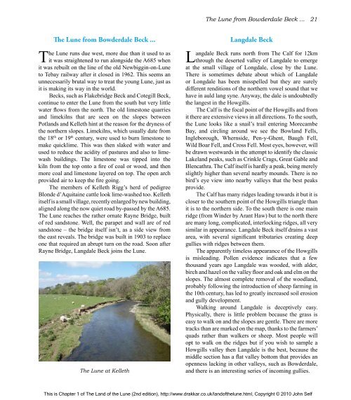
<strong>The</strong> <strong>Lune</strong> at Kelleth<br />
<strong>The</strong> <strong>Lune</strong> from Bowderdale Beck ... 21<br />
Langdale Beck<br />
Langdale Beck runs north from <strong>The</strong> Calf for 12km<br />
through <strong>the</strong> deserted valley <strong>of</strong> Langdale to emerge<br />
at <strong>the</strong> small village <strong>of</strong> Longdale, close by <strong>the</strong> <strong>Lune</strong>.<br />
<strong>The</strong>re is sometimes debate about which <strong>of</strong> Langdale<br />
or Longdale has been misspelled but <strong>the</strong>y are surely<br />
different renditions <strong>of</strong> <strong>the</strong> nor<strong>the</strong>rn vowel sound that we<br />
have in auld lang syne. Anyway, <strong>the</strong> dale is undoubtedly<br />
<strong>the</strong> langest in <strong>the</strong> Howgills.<br />
<strong>The</strong> Calf is <strong>the</strong> focal point <strong>of</strong> <strong>the</strong> Howgills and from<br />
it <strong>the</strong>re are extensive views in all directions. To <strong>the</strong> south,<br />
<strong>the</strong> <strong>Lune</strong> looks like a snail’s trail entering Morecambe<br />
Bay, and circling around we see <strong>the</strong> Bowland Fells,<br />
Ingleborough, Whernside, Pen-y-Ghent, Baugh Fell,<br />
Wild Boar Fell, and Cross Fell. Most eyes, however, will<br />
be drawn westwards in <strong>the</strong> attempt to identify <strong>the</strong> classic<br />
Lakeland peaks, such as Crinkle Crags, Great Gable and<br />
Blencathra. <strong>The</strong> Calf itself is hardly a peak, being merely<br />
slightly higher than several nearby mounds. <strong>The</strong>re is no<br />
bird’s eye view into nearby valleys that <strong>the</strong> best peaks<br />
provide.<br />
<strong>The</strong> Calf has many ridges leading towards it but it is<br />
closer to <strong>the</strong> sou<strong>the</strong>rn point <strong>of</strong> <strong>the</strong> Howgills triangle than<br />
it is to <strong>the</strong> nor<strong>the</strong>rn side. To <strong>the</strong> south <strong>the</strong>re is one main<br />
ridge (from Winder by Arant Haw) but to <strong>the</strong> north <strong>the</strong>re<br />
are many long, complicated, interlocking ridges, all very<br />
similar in appearance. Langdale Beck itself drains a vast<br />
area, with several significant tributaries creating deep<br />
gullies with ridges between <strong>the</strong>m.<br />
<strong>The</strong> apparently timeless appearance <strong>of</strong> <strong>the</strong> Howgills<br />
is misleading. Pollen evidence indicates that a few<br />
thousand years ago Langdale was wooded, with alder,<br />
birch and hazel on <strong>the</strong> valley floor and oak and elm on <strong>the</strong><br />
slopes. <strong>The</strong> almost complete removal <strong>of</strong> <strong>the</strong> woodland,<br />
probably following <strong>the</strong> introduction <strong>of</strong> sheep farming in<br />
<strong>the</strong> 10th century, has led to greatly increased soil erosion<br />
and gully development.<br />
Walking around Langdale is deceptively easy.<br />
Physically, <strong>the</strong>re is little problem because <strong>the</strong> grass is<br />
easy to walk on and <strong>the</strong> slopes are gentle. <strong>The</strong>re are more<br />
tracks than are marked on <strong>the</strong> map, thanks to <strong>the</strong> farmers’<br />
quads ra<strong>the</strong>r than walkers or sheep. Most people will<br />
opt to walk on <strong>the</strong> ridges but if you wish to sample a<br />
Howgills valley <strong>the</strong>n Langdale is <strong>the</strong> best, because <strong>the</strong><br />
middle section has a flat valley bottom that provides an<br />
openness lacking in o<strong>the</strong>r valleys, such as Bowderdale,<br />
and <strong>the</strong>re is an interesting series <strong>of</strong> incoming gullies.<br />
This is Chapter 1 <strong>of</strong> <strong>The</strong> <strong>Land</strong> <strong>of</strong> <strong>the</strong> <strong>Lune</strong> (2nd edition), http://www.drakkar.co.uk/land<strong>of</strong><strong>the</strong>lune.html, Copyright © 2010 John Self

