


Create successful ePaper yourself
Turn your PDF publications into a flip-book with our unique Google optimized e-Paper software.
78 Chapter 4: Upper Raw<strong>the</strong>ydale<br />
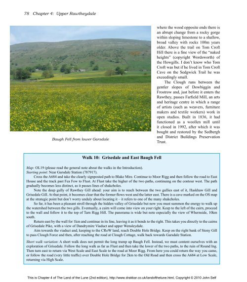
Baugh Fell from lower Garsdale<br />
Walk 10: Grisedale and East Baugh Fell<br />
where <strong>the</strong> wood opposite ends <strong>the</strong>re is<br />
an abrupt change from a rocky gorge<br />
within sloping limestone to a shallow,<br />
broad valley with rocks 100m years<br />
older. Above <strong>the</strong> trail on Tom Cr<strong>of</strong>t<br />
Hill <strong>the</strong>re is a fine view <strong>of</strong> <strong>the</strong> “naked<br />
heights” (copyright Wordsworth) <strong>of</strong><br />
<strong>the</strong> Howgills. I don’t know who Tom<br />
Cr<strong>of</strong>t was but if he lived in Tom Cr<strong>of</strong>t<br />
Cave on <strong>the</strong> Sedgwick Trail he was<br />
exceedingly small.<br />
<strong>The</strong> Clough runs between <strong>the</strong><br />
gentler slopes <strong>of</strong> Dowbiggin and<br />
Frostrow and, just before it enters <strong>the</strong><br />
Raw<strong>the</strong>y, passes Farfield Mill, an arts<br />
and heritage centre in which a range<br />
<strong>of</strong> artists (such as weavers, furniture<br />
makers and textile workers) work in<br />
open studios. Built in 1836, it had<br />
functioned as a woollen mill until<br />
it closed in 1992, after which it was<br />
bought and restored by <strong>the</strong> Sedbergh<br />
and District Buildings Preservation<br />
Trust.<br />
Map: OL19 (please read <strong>the</strong> general note about <strong>the</strong> walks in <strong>the</strong> Introduction).<br />
Starting point: Near Garsdale Station (787917).<br />
Cross <strong>the</strong> A684 and take <strong>the</strong> clearly signposted path to Blake Mire. Continue to Moor Rigg and <strong>the</strong>n follow <strong>the</strong> road to East<br />
House and <strong>the</strong> track past Fea Fow to Flust. At Flust take <strong>the</strong> higher <strong>of</strong> <strong>the</strong> two paths, continuing on <strong>the</strong> contour west. <strong>The</strong> path<br />
gradually becomes less distinct, as it passes lines <strong>of</strong> shakeholes.<br />
Note <strong>the</strong> deep gully <strong>of</strong> Raw<strong>the</strong>y Gill ahead: your aim is to reach between <strong>the</strong> two gullies east <strong>of</strong> it, Haskhaw Gill and<br />
Grisedale Gill. At that point, it becomes clear that <strong>the</strong> former flows west and <strong>the</strong> latter east. <strong>The</strong>re is a cave marked on <strong>the</strong> OS map<br />
at <strong>the</strong> strategic point but don’t worry unduly about locating it – it refers to one <strong>of</strong> <strong>the</strong> many shakeholes.<br />
So far, it has been a pleasant stroll through <strong>the</strong> hidden valley <strong>of</strong> Grisedale but now you must summon <strong>the</strong> energy to walk up<br />
<strong>the</strong> watershed between <strong>the</strong> two gills. Eventually, a cairn will come into view on your right. Keep to <strong>the</strong> left <strong>of</strong> <strong>the</strong> cairn, proceed<br />
to <strong>the</strong> wall and follow it to <strong>the</strong> top <strong>of</strong> Tarn Rigg Hill. <strong>The</strong> panorama is wide but note especially <strong>the</strong> view <strong>of</strong> Whernside, 10km<br />
south.<br />
Return east by <strong>the</strong> wall for 1km and continue in its line, leaving it as it bends to <strong>the</strong> right. This takes you directly to <strong>the</strong> cairns<br />
<strong>of</strong> Grisedale Pike, with a view <strong>of</strong> Dandrymire Viaduct and upper Wensleydale.<br />
Aim towards <strong>the</strong> viaduct and, keeping to <strong>the</strong> CRoW land, reach Double Hole Bridge. Keep on <strong>the</strong> right bank <strong>of</strong> Stony Gill<br />
to pass Clough Force and <strong>the</strong>n, after reaching <strong>the</strong> road at Clough Cottage, walk back towards Garsdale Station.<br />
Short walk variation: A short walk does not permit <strong>the</strong> long tramp up Baugh Fell. Instead, we must content ourselves with an<br />
exploration <strong>of</strong> Grisedale. Follow <strong>the</strong> long walk as far as Flust and <strong>the</strong>n take <strong>the</strong> lower <strong>of</strong> <strong>the</strong> two paths, to <strong>the</strong> ruin <strong>of</strong> Round Ing.<br />
<strong>The</strong>n turn east to return via West Scale and East Scale to <strong>the</strong> road at Moor Rigg. From here you could return <strong>the</strong> way you came,<br />
or follow <strong>the</strong> road (very little traffic) over Double Hole Bridge for 2km to <strong>the</strong> Old Road and <strong>the</strong>n cross <strong>the</strong> A684 at Low Scale,<br />
returning via High Scale.<br />
This is Chapter 4 <strong>of</strong> <strong>The</strong> <strong>Land</strong> <strong>of</strong> <strong>the</strong> <strong>Lune</strong> (2nd edition), http://www.drakkar.co.uk/land<strong>of</strong><strong>the</strong>lune.html, Copyright © 2010 John Self

