


You also want an ePaper? Increase the reach of your titles
YUMPU automatically turns print PDFs into web optimized ePapers that Google loves.
48 Chapter 3: Western Howgills and Firbank Fell<br />
<strong>The</strong> Yorkshire Dales National Park occupies some<br />
1760 sq km and is <strong>the</strong> third largest <strong>of</strong> Britain’s fourteen<br />
National Parks. <strong>The</strong> part we encounter in <strong>the</strong> Howgills is<br />
uncharacteristic <strong>of</strong> <strong>the</strong> Dales, which are normally pictured<br />
in terms <strong>of</strong> spectacular limestone scenery. <strong>The</strong> Yorkshire<br />
Dales are no longer all in Yorkshire: <strong>the</strong> Howgills,<br />
Dentdale and Garsdale are in Cumbria. (Some diehards,<br />
usually Yorkshiremen, consider that <strong>the</strong> 1974 boundaries<br />
defined new administrative regions and had nothing to do<br />
with <strong>the</strong> traditional counties. <strong>The</strong> fact that <strong>the</strong> new regions<br />
were also called counties and that many <strong>of</strong> <strong>the</strong>m used old<br />
county names was unfortunate but irrelevant. On that basis,<br />
<strong>the</strong> sou<strong>the</strong>rn Howgills, Dentdale and Garsdale continue to<br />
be in (<strong>the</strong> traditional county <strong>of</strong>) Yorkshire and are also in<br />
(<strong>the</strong> new administrative region <strong>of</strong>) Cumbria.)<br />
As we will see, only a few <strong>of</strong> <strong>the</strong> Dales lie within Loyne<br />
– Dentdale, Garsdale, Kingsdale and Chapel-le-Dale. <strong>The</strong><br />
<strong>Lune</strong> is <strong>the</strong> western border for 12km and <strong>Lune</strong>sdale is not<br />
sensibly regarded as one <strong>of</strong> <strong>the</strong> Yorkshire Dales.<br />
Like all British National Parks, <strong>the</strong> Yorkshire Dales<br />
National Park is not state-owned but consists <strong>of</strong> privately<br />
owned estates and farms administered by an authority<br />
responsible for conservation and recreation. It is <strong>the</strong>refore<br />
both a tourist attraction and a working area, which even<br />
includes some large quarries.<br />
Carlingill Beck<br />
Carlingill Beck and <strong>the</strong> River <strong>Lune</strong> mark <strong>the</strong><br />
northwestern boundary <strong>of</strong> <strong>the</strong> Yorkshire Dales<br />
National Park. Today this seems anomalous. A boundary<br />
has to be somewhere but <strong>the</strong>re seems no discernible<br />
reason for it to include <strong>the</strong> sou<strong>the</strong>rn part <strong>of</strong> <strong>the</strong> Howgills<br />
but to exclude <strong>the</strong> nor<strong>the</strong>rn part, as <strong>the</strong>y are <strong>the</strong> same<br />
in terms <strong>of</strong> geology and scenery. <strong>The</strong> boundary is here<br />
simply because <strong>the</strong> old Westmorland-Yorkshire county<br />
border lay along Carlingill Beck at <strong>the</strong> time <strong>the</strong> National<br />
Park was established in 1954.<br />
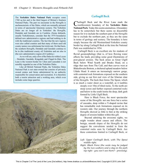
Carlingill Beck is an excellent site for students <strong>of</strong><br />
fluvial geomorphology (that is, <strong>of</strong> how flowing water<br />
affects <strong>the</strong> land), providing some good illustrations <strong>of</strong><br />
post-glacial erosion. <strong>The</strong> beck arises as Great Ulgill<br />
Beck below Wind Scarth and Breaks Head, on a<br />
ridge that runs from <strong>The</strong> Calf, and <strong>the</strong>n curves west at<br />
Blakethwaite Bottom, a sheltered upland meadow below<br />
Uldale Head. It enters an increasingly narrow gorge,<br />
with contorted rock formations exposed on <strong>the</strong> sou<strong>the</strong>rn<br />
side, giving us our first real view <strong>of</strong> <strong>the</strong> Silurian slate<br />
<strong>of</strong> <strong>the</strong> Howgills. <strong>The</strong> beck <strong>the</strong>n forms <strong>The</strong> Spout, which<br />
is as much a water shoot as a waterfall, as it tumbles<br />
steeply over 10m <strong>of</strong> tilted rocks. To <strong>the</strong> north are<br />
steep screes and fur<strong>the</strong>r exposed contorted rocks<br />
and below to <strong>the</strong> south looms <strong>the</strong> deep, dark gash<br />
formed by Little Ulgill Beck.<br />
Here is Black Force, <strong>the</strong> most spectacular<br />
scene <strong>of</strong> <strong>the</strong> Howgills: not one force but a series<br />
<strong>of</strong> cascades, deep within a V-shaped ravine that<br />
has remarkable rock formations exposed on its<br />
western side. Our journey through <strong>the</strong> nor<strong>the</strong>rn<br />
Howgills showed us little to hint at <strong>the</strong> striking<br />
degree <strong>of</strong> erosion hidden within this gill.<br />
Beyond admiring <strong>the</strong> awesome sights, we<br />
might wonder about causes and effects. <strong>The</strong><br />
benign, smooth slopes <strong>of</strong> <strong>the</strong> Howgills do not<br />
suggest <strong>the</strong> convulsions needed to form <strong>the</strong><br />
contorted rocks seen by Carlingill Beck. Are<br />
<strong>the</strong>se contortions limited to Carlingill Beck, or<br />
Left: Upper Carlingill Beck, with <strong>The</strong> Spout<br />
middle right.<br />
Right: Black Force (<strong>the</strong> scale may be judged<br />
by <strong>the</strong> two walkers and a dog on <strong>the</strong> path<br />
top right - you can’t see <strong>the</strong>m? - precisely).<br />
This is Chapter 3 <strong>of</strong> <strong>The</strong> <strong>Land</strong> <strong>of</strong> <strong>the</strong> <strong>Lune</strong> (2nd edition), http://www.drakkar.co.uk/land<strong>of</strong><strong>the</strong>lune.html, Copyright © 2010 John Self

