


Create successful ePaper yourself
Turn your PDF publications into a flip-book with our unique Google optimized e-Paper software.
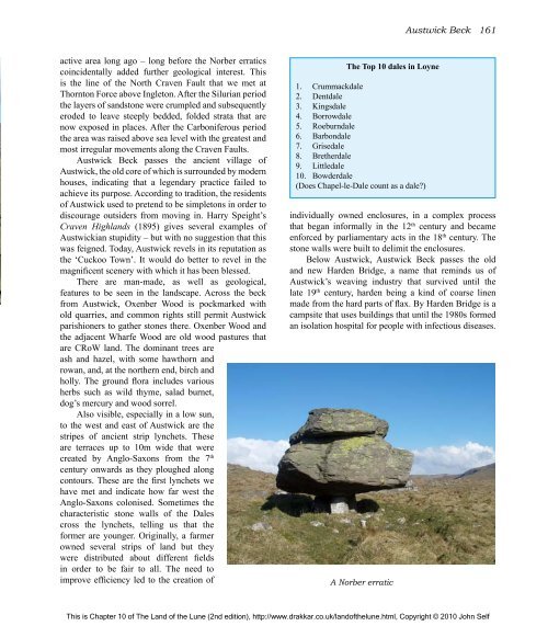
active area long ago – long before <strong>the</strong> Norber erratics<br />
coincidentally added fur<strong>the</strong>r geological interest. This<br />
is <strong>the</strong> line <strong>of</strong> <strong>the</strong> North Craven Fault that we met at<br />
Thornton Force above Ingleton. After <strong>the</strong> Silurian period<br />
<strong>the</strong> layers <strong>of</strong> sandstone were crumpled and subsequently<br />
eroded to leave steeply bedded, folded strata that are<br />
now exposed in places. After <strong>the</strong> Carboniferous period<br />
<strong>the</strong> area was raised above sea level with <strong>the</strong> greatest and<br />
most irregular movements along <strong>the</strong> Craven Faults.<br />
Austwick Beck passes <strong>the</strong> ancient village <strong>of</strong><br />
Austwick, <strong>the</strong> old core <strong>of</strong> which is surrounded by modern<br />
houses, indicating that a legendary practice failed to<br />
achieve its purpose. According to tradition, <strong>the</strong> residents<br />
<strong>of</strong> Austwick used to pretend to be simpletons in order to<br />
discourage outsiders from moving in. Harry Speight’s<br />
Craven Highlands (1895) gives several examples <strong>of</strong><br />
Austwickian stupidity – but with no suggestion that this<br />
was feigned. Today, Austwick revels in its reputation as<br />
<strong>the</strong> ‘Cuckoo Town’. It would do better to revel in <strong>the</strong><br />
magnificent scenery with which it has been blessed.<br />
<strong>The</strong>re are man-made, as well as geological,<br />
features to be seen in <strong>the</strong> landscape. Across <strong>the</strong> beck<br />
from Austwick, Oxenber Wood is pockmarked with<br />
old quarries, and common rights still permit Austwick<br />
parishioners to ga<strong>the</strong>r stones <strong>the</strong>re. Oxenber Wood and<br />
<strong>the</strong> adjacent Wharfe Wood are old wood pastures that<br />
are CRoW land. <strong>The</strong> dominant trees are<br />
ash and hazel, with some hawthorn and<br />
rowan, and, at <strong>the</strong> nor<strong>the</strong>rn end, birch and<br />
holly. <strong>The</strong> ground flora includes various<br />
herbs such as wild thyme, salad burnet,<br />
dog’s mercury and wood sorrel.<br />
Also visible, especially in a low sun,<br />
to <strong>the</strong> west and east <strong>of</strong> Austwick are <strong>the</strong><br />
stripes <strong>of</strong> ancient strip lynchets. <strong>The</strong>se<br />
are terraces up to 10m wide that were<br />
created by Anglo-Saxons from <strong>the</strong> 7 th<br />
century onwards as <strong>the</strong>y ploughed along<br />
contours. <strong>The</strong>se are <strong>the</strong> first lynchets we<br />
have met and indicate how far west <strong>the</strong><br />
Anglo-Saxons colonised. Sometimes <strong>the</strong><br />
characteristic stone walls <strong>of</strong> <strong>the</strong> Dales<br />
cross <strong>the</strong> lynchets, telling us that <strong>the</strong><br />
former are younger. Originally, a farmer<br />
owned several strips <strong>of</strong> land but <strong>the</strong>y<br />
were distributed about different fields<br />
in order to be fair to all. <strong>The</strong> need to<br />
improve efficiency led to <strong>the</strong> creation <strong>of</strong><br />
<strong>The</strong> Top 10 dales in Loyne<br />
1. Crummackdale<br />
2. Dentdale<br />
3. Kingsdale<br />
4. Borrowdale<br />
5. Roeburndale<br />
6. Barbondale<br />
7. Grisedale<br />
8. Bre<strong>the</strong>rdale<br />
9. Littledale<br />
10. Bowderdale<br />
(Does Chapel-le-Dale count as a dale?)<br />
Austwick Beck 161<br />
individually owned enclosures, in a complex process<br />
that began informally in <strong>the</strong> 12 th century and became<br />
enforced by parliamentary acts in <strong>the</strong> 18 th century. <strong>The</strong><br />
stone walls were built to delimit <strong>the</strong> enclosures.<br />
Below Austwick, Austwick Beck passes <strong>the</strong> old<br />
and new Harden Bridge, a name that reminds us <strong>of</strong><br />
Austwick’s weaving industry that survived until <strong>the</strong><br />
late 19 th century, harden being a kind <strong>of</strong> coarse linen<br />
made from <strong>the</strong> hard parts <strong>of</strong> flax. By Harden Bridge is a<br />
campsite that uses buildings that until <strong>the</strong> 1980s formed<br />
an isolation hospital for people with infectious diseases.<br />
A Norber erratic<br />
This is Chapter 10 <strong>of</strong> <strong>The</strong> <strong>Land</strong> <strong>of</strong> <strong>the</strong> <strong>Lune</strong> (2nd edition), http://www.drakkar.co.uk/land<strong>of</strong><strong>the</strong>lune.html, Copyright © 2010 John Self

