


You also want an ePaper? Increase the reach of your titles
YUMPU automatically turns print PDFs into web optimized ePapers that Google loves.
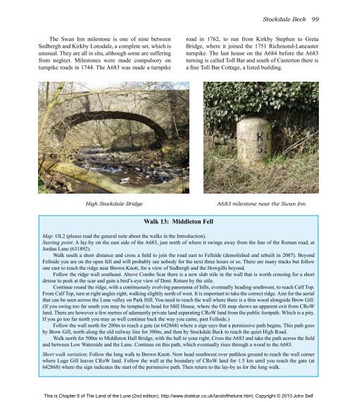
<strong>The</strong> Swan Inn milestone is one <strong>of</strong> nine between<br />
Sedbergh and Kirkby Lonsdale, a complete set, which is<br />
unusual. <strong>The</strong>y are all in situ, although some are suffering<br />
from neglect. Milestones were made compulsory on<br />
turnpike roads in 1744. <strong>The</strong> A683 was made a turnpike<br />
Walk 13: Middleton Fell<br />
Stockdale Beck 99<br />
road in 1762, to run from Kirkby Stephen to Greta<br />
Bridge, where it joined <strong>the</strong> 1751 Richmond-Lancaster<br />
turnpike. <strong>The</strong> last house on <strong>the</strong> A684 before <strong>the</strong> A683<br />
turning is called Toll Bar and south <strong>of</strong> Casterton <strong>the</strong>re is<br />
a fine Toll Bar Cottage, a listed building.<br />
High Stockdale Bridge A683 milestone near <strong>the</strong> Swan Inn<br />
Map: OL2 (please read <strong>the</strong> general note about <strong>the</strong> walks in <strong>the</strong> Introduction).<br />
Starting point: A lay-by on <strong>the</strong> east side <strong>of</strong> <strong>the</strong> A683, just north <strong>of</strong> where it swings away from <strong>the</strong> line <strong>of</strong> <strong>the</strong> Roman road, at<br />
Jordan Lane (631892).<br />
Walk south a short distance and cross a field to join <strong>the</strong> road east to Fellside (demolished and rebuilt in 2007). Beyond<br />
Fellside you are on <strong>the</strong> open fell and will probably see nobody for <strong>the</strong> next three hours or so. <strong>The</strong>re are many tracks but follow<br />
one east to reach <strong>the</strong> ridge near Brown Knott, for a view <strong>of</strong> Sedbergh and <strong>the</strong> Howgills beyond.<br />
Follow <strong>the</strong> ridge wall sou<strong>the</strong>ast. Above Combe Scar <strong>the</strong>re is a new slab stile in <strong>the</strong> wall that is worth crossing for a short<br />
detour to peek at <strong>the</strong> scar and gain a bird’s-eye view <strong>of</strong> Dent. Return by <strong>the</strong> stile.<br />
Continue round <strong>the</strong> ridge, with a continuously evolving panorama <strong>of</strong> hills, eventually heading southwest, to reach Calf Top.<br />
From Calf Top, turn at right angles right, walking slightly north <strong>of</strong> west. It is important to take <strong>the</strong> correct ridge. Aim for <strong>the</strong> aerial<br />
that can be seen across <strong>the</strong> <strong>Lune</strong> valley on Park Hill. You need to reach <strong>the</strong> wall where <strong>the</strong>re is a thin wood alongside Brow Gill.<br />
(If you swing too far south you may be tempted to head for Mill House, where <strong>the</strong> OS map shows an apparent exit from CRoW<br />
land. <strong>The</strong>re are however a few metres <strong>of</strong> adamantly private land separating CRoW land from <strong>the</strong> public footpath. Which is a pity.<br />
If you go too far north you may as well continue back <strong>the</strong> way you came, past Fellside.)<br />
Follow <strong>the</strong> wall north for 200m to reach a gate (at 642868) where a sign says that a permissive path begins. This path goes<br />
by Brow Gill, north along <strong>the</strong> old railway line for 300m, and <strong>the</strong>n by Stockdale Beck to reach <strong>the</strong> quiet High Road.<br />
Walk north for 500m to Middleton Hall Bridge, with <strong>the</strong> hall to your right. Cross <strong>the</strong> A683 and take <strong>the</strong> path across <strong>the</strong> field<br />
and between Low Waterside and <strong>the</strong> <strong>Lune</strong>. Continue on this path, which eventually rises through a wood to <strong>the</strong> A683.<br />
Short walk variation: Follow <strong>the</strong> long walk to Brown Knott. Now head southwest over pathless ground to reach <strong>the</strong> wall corner<br />
where Luge Gill leaves CRoW land. Follow <strong>the</strong> wall at <strong>the</strong> boundary <strong>of</strong> CRoW land for 1.5 km until you reach <strong>the</strong> gate (at<br />
642868) where <strong>the</strong> sign indicates <strong>the</strong> start <strong>of</strong> <strong>the</strong> permissive path. <strong>The</strong>n return to <strong>the</strong> lay-by as for <strong>the</strong> long walk.<br />
This is Chapter 6 <strong>of</strong> <strong>The</strong> <strong>Land</strong> <strong>of</strong> <strong>the</strong> <strong>Lune</strong> (2nd edition), http://www.drakkar.co.uk/land<strong>of</strong><strong>the</strong>lune.html, Copyright © 2010 John Self

