


You also want an ePaper? Increase the reach of your titles
YUMPU automatically turns print PDFs into web optimized ePapers that Google loves.
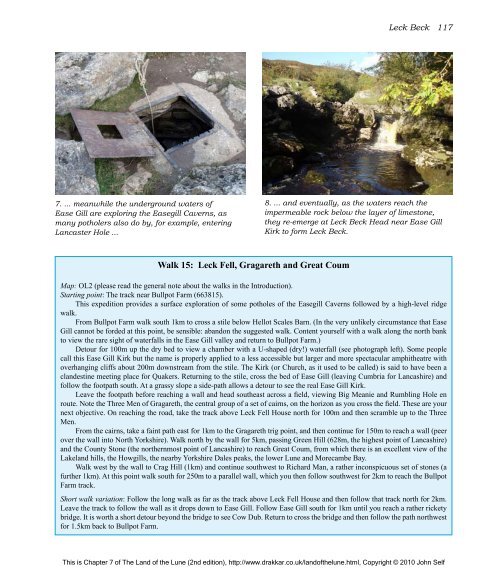
7. ... meanwhile <strong>the</strong> underground waters <strong>of</strong><br />
Ease Gill are exploring <strong>the</strong> Easegill Caverns, as<br />
many potholers also do by, for example, entering<br />
Lancaster Hole ...<br />
Walk 15: Leck Fell, Gragareth and Great Coum<br />
Leck Beck 117<br />
8. ... and eventually, as <strong>the</strong> waters reach <strong>the</strong><br />
impermeable rock below <strong>the</strong> layer <strong>of</strong> limestone,<br />
<strong>the</strong>y re-emerge at Leck Beck Head near Ease Gill<br />
Kirk to form Leck Beck.<br />
Map: OL2 (please read <strong>the</strong> general note about <strong>the</strong> walks in <strong>the</strong> Introduction).<br />
Starting point: <strong>The</strong> track near Bullpot Farm (663815).<br />
This expedition provides a surface exploration <strong>of</strong> some potholes <strong>of</strong> <strong>the</strong> Easegill Caverns followed by a high-level ridge<br />
walk.<br />
From Bullpot Farm walk south 1km to cross a stile below Hellot Scales Barn. (In <strong>the</strong> very unlikely circumstance that Ease<br />
Gill cannot be forded at this point, be sensible: abandon <strong>the</strong> suggested walk. Content yourself with a walk along <strong>the</strong> north bank<br />
to view <strong>the</strong> rare sight <strong>of</strong> waterfalls in <strong>the</strong> Ease Gill valley and return to Bullpot Farm.)<br />
Detour for 100m up <strong>the</strong> dry bed to view a chamber with a U-shaped (dry!) waterfall (see photograph left). Some people<br />
call this Ease Gill Kirk but <strong>the</strong> name is properly applied to a less accessible but larger and more spectacular amphi<strong>the</strong>atre with<br />
overhanging cliffs about 200m downstream from <strong>the</strong> stile. <strong>The</strong> Kirk (or Church, as it used to be called) is said to have been a<br />
clandestine meeting place for Quakers. Returning to <strong>the</strong> stile, cross <strong>the</strong> bed <strong>of</strong> Ease Gill (leaving Cumbria for Lancashire) and<br />
follow <strong>the</strong> footpath south. At a grassy slope a side-path allows a detour to see <strong>the</strong> real Ease Gill Kirk.<br />
Leave <strong>the</strong> footpath before reaching a wall and head sou<strong>the</strong>ast across a field, viewing Big Meanie and Rumbling Hole en<br />
route. Note <strong>the</strong> Three Men <strong>of</strong> Gragareth, <strong>the</strong> central group <strong>of</strong> a set <strong>of</strong> cairns, on <strong>the</strong> horizon as you cross <strong>the</strong> field. <strong>The</strong>se are your<br />
next objective. On reaching <strong>the</strong> road, take <strong>the</strong> track above Leck Fell House north for 100m and <strong>the</strong>n scramble up to <strong>the</strong> Three<br />
Men.<br />
From <strong>the</strong> cairns, take a faint path east for 1km to <strong>the</strong> Gragareth trig point, and <strong>the</strong>n continue for 150m to reach a wall (peer<br />
over <strong>the</strong> wall into North Yorkshire). Walk north by <strong>the</strong> wall for 5km, passing Green Hill (628m, <strong>the</strong> highest point <strong>of</strong> Lancashire)<br />
and <strong>the</strong> County Stone (<strong>the</strong> nor<strong>the</strong>rnmost point <strong>of</strong> Lancashire) to reach Great Coum, from which <strong>the</strong>re is an excellent view <strong>of</strong> <strong>the</strong><br />
Lakeland hills, <strong>the</strong> Howgills, <strong>the</strong> nearby Yorkshire Dales peaks, <strong>the</strong> lower <strong>Lune</strong> and Morecambe Bay.<br />
Walk west by <strong>the</strong> wall to Crag Hill (1km) and continue southwest to Richard Man, a ra<strong>the</strong>r inconspicuous set <strong>of</strong> stones (a<br />
fur<strong>the</strong>r 1km). At this point walk south for 250m to a parallel wall, which you <strong>the</strong>n follow southwest for 2km to reach <strong>the</strong> Bullpot<br />
Farm track.<br />
Short walk variation: Follow <strong>the</strong> long walk as far as <strong>the</strong> track above Leck Fell House and <strong>the</strong>n follow that track north for 2km.<br />
Leave <strong>the</strong> track to follow <strong>the</strong> wall as it drops down to Ease Gill. Follow Ease Gill south for 1km until you reach a ra<strong>the</strong>r rickety<br />
bridge. It is worth a short detour beyond <strong>the</strong> bridge to see Cow Dub. Return to cross <strong>the</strong> bridge and <strong>the</strong>n follow <strong>the</strong> path northwest<br />
for 1.5km back to Bullpot Farm.<br />
This is Chapter 7 <strong>of</strong> <strong>The</strong> <strong>Land</strong> <strong>of</strong> <strong>the</strong> <strong>Lune</strong> (2nd edition), http://www.drakkar.co.uk/land<strong>of</strong><strong>the</strong>lune.html, Copyright © 2010 John Self

