You also want an ePaper? Increase the reach of your titles
YUMPU automatically turns print PDFs into web optimized ePapers that Google loves.
<strong>The</strong> River Hindburn<br />
By <strong>the</strong> time it reaches Botton Bridge <strong>the</strong> River<br />
Hindburn is already a considerable size, having<br />
ga<strong>the</strong>red up all <strong>the</strong> becks that drain Greenbank Fell,<br />
Botton Head Fell and Whitray Fell below <strong>the</strong> semicircular<br />
ridge that runs to <strong>the</strong> ancient Cross <strong>of</strong> Greet<br />
(which is no longer a cross but a large boulder with a<br />
socket in which a cross may once have stood). This is<br />
a vast area <strong>of</strong> peat bogs and hea<strong>the</strong>r, turning to grass<br />
tussocks lower down. It is all CRoW land but walking<br />
here is more <strong>of</strong> a challenge than a pleasure. In winter,<br />
<strong>the</strong>re are only grouse for company. From <strong>the</strong> ridge <strong>the</strong>re<br />
are broad views <strong>of</strong> Pendle and <strong>the</strong> sou<strong>the</strong>rn Bowland<br />
Fells and to <strong>the</strong> north Whernside looks particularly noble<br />
(Ingleborough always does). <strong>The</strong> alignment <strong>of</strong> <strong>the</strong> ridges<br />
Left (top): Wennington Hall.<br />
Left (bottom): <strong>The</strong> Wenning at Wennington.<br />
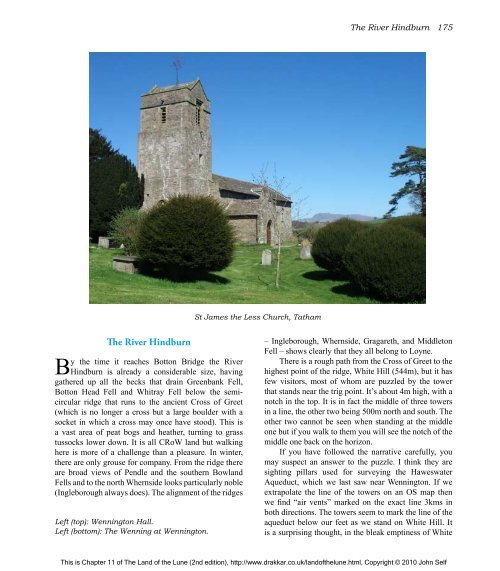
St James <strong>the</strong> Less Church, Tatham<br />
<strong>The</strong> River Hindburn 175<br />
– Ingleborough, Whernside, Gragareth, and Middleton<br />
Fell – shows clearly that <strong>the</strong>y all belong to Loyne.<br />
<strong>The</strong>re is a rough path from <strong>the</strong> Cross <strong>of</strong> Greet to <strong>the</strong><br />
highest point <strong>of</strong> <strong>the</strong> ridge, White Hill (544m), but it has<br />
few visitors, most <strong>of</strong> whom are puzzled by <strong>the</strong> tower<br />
that stands near <strong>the</strong> trig point. It’s about 4m high, with a<br />
notch in <strong>the</strong> top. It is in fact <strong>the</strong> middle <strong>of</strong> three towers<br />
in a line, <strong>the</strong> o<strong>the</strong>r two being 500m north and south. <strong>The</strong><br />
o<strong>the</strong>r two cannot be seen when standing at <strong>the</strong> middle<br />
one but if you walk to <strong>the</strong>m you will see <strong>the</strong> notch <strong>of</strong> <strong>the</strong><br />
middle one back on <strong>the</strong> horizon.<br />
If you have followed <strong>the</strong> narrative carefully, you<br />
may suspect an answer to <strong>the</strong> puzzle. I think <strong>the</strong>y are<br />
sighting pillars used for surveying <strong>the</strong> Haweswater<br />
Aqueduct, which we last saw near Wennington. If we<br />
extrapolate <strong>the</strong> line <strong>of</strong> <strong>the</strong> towers on an OS map <strong>the</strong>n<br />
we find “air vents” marked on <strong>the</strong> exact line 3kms in<br />
both directions. <strong>The</strong> towers seem to mark <strong>the</strong> line <strong>of</strong> <strong>the</strong><br />
aqueduct below our feet as we stand on White Hill. It<br />
is a surprising thought, in <strong>the</strong> bleak emptiness <strong>of</strong> White<br />
This is Chapter 11 <strong>of</strong> <strong>The</strong> <strong>Land</strong> <strong>of</strong> <strong>the</strong> <strong>Lune</strong> (2nd edition), http://www.drakkar.co.uk/land<strong>of</strong><strong>the</strong>lune.html, Copyright © 2010 John Self


