


Create successful ePaper yourself
Turn your PDF publications into a flip-book with our unique Google optimized e-Paper software.
<strong>The</strong> River Raw<strong>the</strong>y ...<br />
Like <strong>the</strong> <strong>Lune</strong>, <strong>the</strong> Raw<strong>the</strong>y first flows north (as<br />
Raw<strong>the</strong>y Gill <strong>of</strong>f Baugh Fell) and <strong>the</strong>n swings west<br />
and south. Baugh Fell is <strong>the</strong> largest mountain <strong>of</strong><br />
Loyne, in terms <strong>of</strong> volume, that is, not height, occupying<br />
<strong>the</strong> huge expanse <strong>of</strong> high ground between <strong>the</strong> A683, <strong>the</strong><br />
A684 and <strong>the</strong> Raw<strong>the</strong>y-Grisedale valley. It is one <strong>of</strong> <strong>the</strong><br />
least visited <strong>of</strong> <strong>the</strong> peaks <strong>of</strong> <strong>the</strong> Yorkshire Dales and<br />
understandably so, because it is surrounded by many<br />
more attractive challenges.<br />
It is pudding-shaped, with <strong>the</strong> unappealing<br />
characteristic, for a walker, <strong>of</strong> being relentlessly uphill<br />
from whichever direction you tackle it and <strong>of</strong> having a top<br />
that is always over <strong>the</strong> horizon. <strong>The</strong>re is little <strong>of</strong> interest<br />
above 400m. And when you reach <strong>the</strong> top, you cannot<br />
be sure that you are <strong>the</strong>re. <strong>The</strong> trig point at Knoutberry<br />
Haw is, according to <strong>the</strong> OS map, 2m lower than <strong>the</strong><br />
unmarked, gentle summit at Tarn Rigg Hill (678m).<br />
Some would say that Baugh Fell is pudding-textured<br />
too but that is an exaggeration. Yes, it tends to be wet<br />
and <strong>the</strong>re are peat mounds to negotiate but <strong>the</strong>re’s plenty<br />
<strong>of</strong> grass and <strong>the</strong> top is a rough, stony plateau. Still, it is<br />
one <strong>of</strong> those mountains best tackled when <strong>the</strong> ground<br />
is frozen solid and <strong>the</strong>re’s a layer <strong>of</strong> snow to hide <strong>the</strong><br />
desolation.<br />
Baugh Fell is not <strong>the</strong> most exciting fell but it does<br />
provide a magnificent view in all directions: circling<br />
from <strong>the</strong> north Wild Boar Fell, Mallerstang, Great<br />
Shunner Fell, Pen-y-Ghent, Pendle, Ingleborough,<br />
Whernside, Great Coum, <strong>the</strong> Lakeland Peaks, and <strong>the</strong><br />
<strong>The</strong> River Raw<strong>the</strong>y ... 63<br />
Howgills. <strong>The</strong> views <strong>of</strong> Whernside and Great Coum are<br />
particularly striking. From o<strong>the</strong>r directions <strong>the</strong>y appear<br />
unremarkable but from here <strong>the</strong>y have majestic pr<strong>of</strong>iles.<br />
After 3km Raw<strong>the</strong>y Gill turns a left angle, becoming<br />
<strong>the</strong> River Raw<strong>the</strong>y, to run through a limestone gorge<br />
and over a series <strong>of</strong> waterfalls, one <strong>of</strong> which at least<br />
deserves a distinctive name. Some call it Uldale Force<br />
but Uldale seems to be <strong>the</strong> area north <strong>of</strong> Holmes Moss,<br />
with Uldale Gill fur<strong>the</strong>r north still. What’s wrong with<br />
a simple Raw<strong>the</strong>y Force? Anyway, <strong>the</strong> 10m waterfall is<br />
quite <strong>the</strong> equal <strong>of</strong> more illustrious waterfalls that we will<br />
meet later.<br />
Whin Stone Gill, Blea Gill and Needlehouse Gill<br />
(which begins as Uldale Gill) join <strong>the</strong> Raw<strong>the</strong>y <strong>of</strong>f <strong>the</strong><br />
western slopes <strong>of</strong> Swarth Fell, which is one <strong>of</strong> those<br />
underrated hills that suffer by comparison with a near<br />
neighbour (no, not Baugh Fell – Wild Boar Fell to <strong>the</strong><br />
north). At 681m, Swarth Fell is higher than <strong>the</strong> Howgills<br />
and Baugh Fell and, with a flattish top and crags to<br />
<strong>the</strong> east, has <strong>the</strong> characteristic shape <strong>of</strong> <strong>the</strong> peaks <strong>of</strong><br />
<strong>the</strong> Yorkshire Dales, although it is only half within <strong>the</strong><br />
National Park.<br />
Swarth Fell also has <strong>the</strong> distinction <strong>of</strong> lying on <strong>the</strong><br />
‘national divide’ <strong>of</strong> England. From its sou<strong>the</strong>rn ridge,<br />
waters to <strong>the</strong> east flow (via <strong>the</strong> River Ure) to <strong>the</strong> North<br />
Two pages before: From Fell End Clouds towards<br />
Cautley Crag.<br />
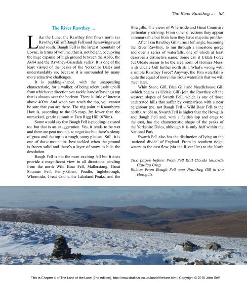
Below: From Baugh Fell over Raw<strong>the</strong>y Gill to <strong>the</strong><br />
Howgills.<br />
This is Chapter 4 <strong>of</strong> <strong>The</strong> <strong>Land</strong> <strong>of</strong> <strong>the</strong> <strong>Lune</strong> (2nd edition), http://www.drakkar.co.uk/land<strong>of</strong><strong>the</strong>lune.html, Copyright © 2010 John Self

