


You also want an ePaper? Increase the reach of your titles
YUMPU automatically turns print PDFs into web optimized ePapers that Google loves.
152 Chapter 9: Gretadale and a little more <strong>Lune</strong>sdale<br />
although we are still some distance from typical Bowland<br />
country. <strong>The</strong> ambivalent regard for <strong>the</strong> Bowland region<br />
is indicated by <strong>the</strong> inclusion <strong>of</strong> “Bowland and <strong>the</strong> <strong>Lune</strong><br />
Valley” (where <strong>the</strong>y mean <strong>the</strong> lower <strong>Lune</strong> valley) as one<br />
<strong>of</strong> twelve projects within <strong>the</strong> Culture 2000 European<br />
Pathways to Cultural <strong>Land</strong>scapes programme, funded by<br />
<strong>the</strong> European Union. This sounds like an honour indeed<br />
– until we read that <strong>the</strong> project is “dedicated to ‘marginal’<br />
landscapes, border regions and landscapes whose image<br />
is one <strong>of</strong> poverty and historical insignificance”.<br />
<strong>The</strong> <strong>Lune</strong> passes below Priory Farm, which is on<br />
<strong>the</strong> site <strong>of</strong> an old Premonstratensian priory, that is, one<br />
belonging to <strong>the</strong> order <strong>of</strong> ‘White Canons’ (from <strong>the</strong><br />
colour <strong>of</strong> <strong>the</strong>ir habit) founded at Prémontré in France.<br />
Shortly after, <strong>the</strong> small Gressingham Beck enters from<br />
<strong>the</strong> west. This beck ga<strong>the</strong>rs <strong>the</strong> waters from <strong>the</strong> rolling<br />
green hinterland beyond <strong>the</strong> western ridge and, with<br />
<strong>The</strong> Forest <strong>of</strong> Bowland was designated an Area <strong>of</strong><br />
Outstanding Natural Beauty (AONB) in 1964 and its 800<br />
sq km make it <strong>the</strong> 11th largest <strong>of</strong> <strong>the</strong> 41 AONBs in England<br />
and Wales. An AONB designation recognises a region’s<br />
scenic qualities and implies a commitment to conserve<br />
its flora, fauna and landscape features, consistent with <strong>the</strong><br />
needs <strong>of</strong> residents. Only <strong>the</strong> nor<strong>the</strong>rn third <strong>of</strong> Bowland lies<br />
within Loyne. <strong>The</strong> remainder, reached by <strong>the</strong> two bleak<br />
roads to Slaidburn or through <strong>the</strong> Trough <strong>of</strong> Bowland,<br />
drains to <strong>the</strong> Wyre or Ribble.<br />
<strong>The</strong> Forest <strong>of</strong> Bowland is a forest in <strong>the</strong> historical sense<br />
<strong>of</strong> an unenclosed, outlying region <strong>of</strong> little use except for<br />
hunting. Bowland was originally a Royal Forest, although<br />
no sovereign is known to have hunted here. However, Henry<br />
VI was himself hunted, when in 1465, during <strong>the</strong> Wars<br />
<strong>of</strong> <strong>the</strong> Roses, he hid in Bolton-by-Bowland. Traditional<br />
hunting has long gone, to be replaced by grouse shooting,<br />
mainly on land owned by England’s richest aristocrat, <strong>the</strong><br />
Duke <strong>of</strong> Westminster. Until <strong>the</strong> Countryside and Rights <strong>of</strong><br />
Way Act took effect in 2004 (launched in Bowland), this<br />
was England’s largest area without public access.<br />
Lower Bowland consists <strong>of</strong> rolling green pastures<br />
with picturesque grey stone buildings. <strong>The</strong> upland areas are<br />
<strong>of</strong> millstone grit, with thin layers <strong>of</strong> sandstone and shale<br />
on <strong>the</strong> slopes, giving rise to open and wild upland areas<br />
<strong>of</strong> blanket bog and hea<strong>the</strong>r moorland that are incised by<br />
fast becks to form steep cloughs and wooded valleys. <strong>The</strong><br />
wilderness areas <strong>of</strong> Bowland remain largely unspoilt by<br />
exploitation, with <strong>the</strong> works <strong>of</strong> <strong>the</strong> water authorities and<br />
<strong>the</strong> Forestry Commission lying mainly outside Loyne. <strong>The</strong><br />
higher fells have been maintained in a relatively natural<br />
state for <strong>the</strong> sheep and grouse and, since 2004, humans.<br />
High Dam Beck (which runs from <strong>the</strong> ‘high dam’ that<br />
used to power <strong>the</strong> mill), channels <strong>the</strong>m through <strong>the</strong><br />
ancient village <strong>of</strong> Gressingham.<br />
Gressingham is ano<strong>the</strong>r <strong>of</strong> Earl Tostig’s holdings<br />
that was listed in <strong>the</strong> Domesday Book (as Ghersinctune)<br />
but nothing much has happened here since. <strong>The</strong> small<br />
triangle <strong>of</strong> homesteads and <strong>the</strong> line <strong>of</strong> dwellings by <strong>the</strong><br />
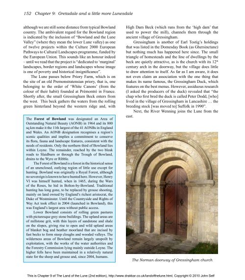
beck are quietly attractive, as is <strong>the</strong> church with its 12 th<br />
century arch in <strong>the</strong> doorway, but <strong>the</strong> village does little<br />
to draw attention to itself. As far as I am aware, it does<br />
not even claim an association with <strong>the</strong> one thing that<br />
makes its name famous, <strong>the</strong> Gressingham Duck, which<br />
features on <strong>the</strong> best menus. However, assiduous research<br />
(I asked <strong>the</strong> producers <strong>of</strong> <strong>the</strong> duck) revealed that “<strong>the</strong><br />
chap who first bred <strong>the</strong> duck is called Peter Dodd, [who]<br />
lived in <strong>the</strong> village <strong>of</strong> Gressingham in Lancashire … <strong>the</strong><br />
breeding stock [was moved to] Suffolk in 1990”.<br />
Next, <strong>the</strong> River Wenning joins <strong>the</strong> <strong>Lune</strong> from <strong>the</strong><br />
east.<br />
<strong>The</strong> Norman doorway <strong>of</strong> Gressingham church<br />
This is Chapter 9 <strong>of</strong> <strong>The</strong> <strong>Land</strong> <strong>of</strong> <strong>the</strong> <strong>Lune</strong> (2nd edition), http://www.drakkar.co.uk/land<strong>of</strong><strong>the</strong>lune.html, Copyright © 2010 John Self

