


Create successful ePaper yourself
Turn your PDF publications into a flip-book with our unique Google optimized e-Paper software.
To <strong>the</strong> south <strong>of</strong> Fell End Clouds, Clouds Gill makes<br />
a brave effort to cross <strong>the</strong> limestone to reach Sally Beck.<br />
Most <strong>of</strong> <strong>the</strong> time it fails but sometimes, judging by <strong>the</strong><br />
erosion, it succeeds with a vengeance. It flows from<br />
Sand Tarn, a perhaps unexpected oasis just below <strong>the</strong><br />
Wild Boar Fell trig point.<br />
At 708m, Wild Boar Fell is <strong>the</strong> highest hill we have<br />
met so far – and <strong>the</strong> most dramatic, although admittedly<br />
most <strong>of</strong> <strong>the</strong> drama is on <strong>the</strong> eastern slopes, which are<br />
within <strong>the</strong> Eden catchment area. <strong>The</strong> broader, western<br />
slopes drain to <strong>the</strong> <strong>Lune</strong>, via <strong>the</strong> Raw<strong>the</strong>y.<br />
Wild Boar Fell has a flat top, with many cairns.<br />
Those on <strong>the</strong> eastern rim provide marvellous views<br />
into Mallerstang and across to <strong>the</strong> hills <strong>of</strong> <strong>the</strong> Yorkshire<br />
Dales. <strong>The</strong> trig point is on <strong>the</strong> western edge and provides<br />
a unique viewpoint down onto <strong>the</strong> Howgills, giving a<br />
wonderful impression <strong>of</strong> <strong>the</strong> rolling contours.<br />
Wild Boar Fell is so called because <strong>the</strong> last English<br />
wild boar fell here, or so it is said. In case you should<br />
be sceptical, we are given a date and perpetrator for <strong>the</strong><br />
deed: 1396 and Sir Richard Musgrave <strong>of</strong> Hartley Castle.<br />
If doubts still remain, <strong>the</strong>n we’re told that his tomb in<br />
Kirkby Stephen church was found to contain a boar’s<br />
<strong>The</strong> Top 10 lakes in Loyne<br />
Sally Beck 67<br />
(Are <strong>the</strong>re 10 lakes in Loyne?)<br />
1. Sand Tarn, Wild Boar Fell<br />
2. Greensett Tarn, Whernside<br />
3. Sunbiggin Tarn<br />
4. Whernside Tarns (could count as four?)<br />
5. West Baugh Fell Tarn (a good view, at least)<br />
6. Kitmere (but can hardly see it)<br />
7. East Tarns, Baugh Fell (ano<strong>the</strong>r five or more?)<br />
8. Terrybank Tarn<br />
9. Island Pond, Quernmore<br />
10. <strong>The</strong> Lake, Clapham Beck (but it’s artificial)<br />
(Only just.)<br />
tusk. But your clinching counter-argument is that <strong>the</strong>re<br />
are wild boars in England now.<br />
As Clouds Gill passes <strong>the</strong> limestone it reaches an<br />
appealing high-level road that was <strong>the</strong> original road but<br />
is now a quiet by-way above <strong>the</strong> A683. It is open to <strong>the</strong><br />
fell, has wide grassy verges, and has a line <strong>of</strong> farmsteads<br />
most <strong>of</strong> which are being revitalised as holiday homes.<br />
Cold Keld, for example, <strong>of</strong>fers guided walking holidays.<br />
To <strong>the</strong> south is Fell End bunkhouse, which is owned by<br />
Left: Sand Tarn, with Harter Fell (with its Five Gills) beyond, and beyond that Green Bell, with Randygill Top,<br />
Kensgriff and Yarlside to <strong>the</strong> left, and with <strong>the</strong> Lake District hills in <strong>the</strong> distance.<br />
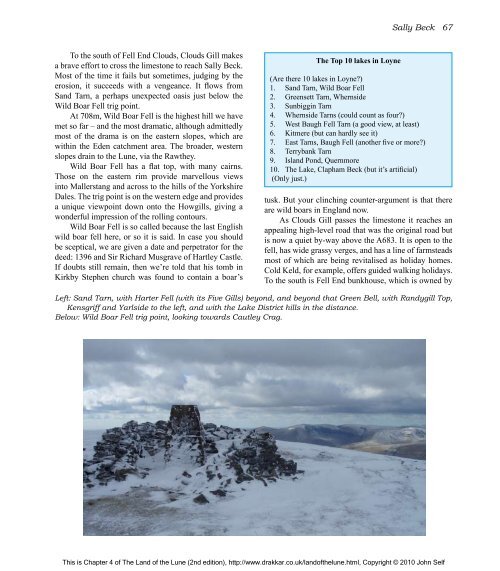
Below: Wild Boar Fell trig point, looking towards Cautley Crag.<br />
This is Chapter 4 <strong>of</strong> <strong>The</strong> <strong>Land</strong> <strong>of</strong> <strong>the</strong> <strong>Lune</strong> (2nd edition), http://www.drakkar.co.uk/land<strong>of</strong><strong>the</strong>lune.html, Copyright © 2010 John Self

