Lismore to Mullumbimby Electricity Network ... - Essential Energy
Lismore to Mullumbimby Electricity Network ... - Essential Energy
Lismore to Mullumbimby Electricity Network ... - Essential Energy

You also want an ePaper? Increase the reach of your titles
YUMPU automatically turns print PDFs into web optimized ePapers that Google loves.
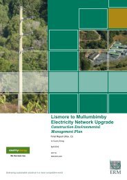
ALSTONVILLE<br />
Legend<br />
Substation Lot<br />
Roads likely <strong>to</strong> be utilised by Project Activities<br />
Likely Heavy Vehicle Routes<br />
Proposed Als<strong>to</strong>nville Bypass<br />
132kV Aboveground Upgrade<br />
66/132kV Dual Circuit Upgrade<br />
132kV Underground Upgrade<br />
NSW Roadways<br />
Casino-Murwillumbah Railway<br />
Drainage<br />
Built Up Area<br />
Figure 5.7<br />
Project Interaction with Als<strong>to</strong>nville<br />
Bypass<br />
Client:<br />
Project:<br />
Country <strong>Energy</strong><br />
<strong>Lismore</strong> <strong>to</strong> <strong>Mullumbimby</strong><br />
Electricty <strong>Network</strong> Upgrade<br />
Drawing No:<br />
Date:<br />
Drawn by:<br />
Scale:<br />
0051706pm_Traffic_ALST BYPASS_V1<br />
29/03/2010 TH<br />
Refer <strong>to</strong> Scale Bar<br />
Drawing size: Reviewed by: A4<br />
MC<br />
0 200 400 600m<br />
Maps and figures contained within this document may be based on third<br />
party data, may not be <strong>to</strong> scale and is intended for use as a guide only.<br />
ERM does not warrant the accuracy of any such maps or figures.<br />
Environmental Resources Management Australia Pty Ltd<br />
Suite 3, 146-148 Gordon St Port Macquarie NSW 2444<br />
Telephone +61 2 6584 7155<br />
GAP RD<br />
PATH<br />
GRANADA PDE<br />
TEVEN RD<br />
PANORAMA DR<br />
MANTULA PL<br />
MO N TE G O PDE<br />
PANORAMA DR<br />
SCENIC CT<br />
IEW DR<br />
OCEAN V<br />
C E DA R CT<br />
V ALLEY DR<br />
BRUXNER HWY<br />
URALBA RD<br />
TANAM E R A DR<br />
ADELE ST<br />
SOUTH ST<br />
BUGDEN AV<br />
PATH<br />
T A NAME R A DR<br />
PATH<br />
WHIPPS AV<br />
DEEGAN AV<br />
GREEN ST<br />
DALEY ST<br />
BROWN AV<br />
PARKLAND DR<br />
R OBERTSON ST<br />
PATH<br />
COOKE AV<br />
PATH<br />
WARDELL RD<br />
MAIN LISMORE RD<br />
PATH<br />
ALSTON AV<br />
MELLIS CCT<br />
PATH<br />
CAWLEY CL<br />
CORAL ST<br />
ASHLAND ST<br />
AL CR<br />
OP<br />
MA P<br />
ELLIS RD<br />
KYLA ST<br />
LE DR<br />
L<br />
G RAYS<br />
Map section reproduced with permission of UBD. © Universal Publishers Pty Ltd 06/07<br />
© DEPARTMENT OF LANDS www.lands.nsw.gov.au<br />
Source:<br />
Als<strong>to</strong>nville Bypass Concept Plan - NSW RTA<br />
[<br />
N