Long Term Community Plan 2012-2022 - Hurunui District Council
Long Term Community Plan 2012-2022 - Hurunui District Council
Long Term Community Plan 2012-2022 - Hurunui District Council

Create successful ePaper yourself
Turn your PDF publications into a flip-book with our unique Google optimized e-Paper software.
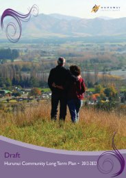
<strong>Hurunui</strong> <strong>Community</strong> <strong>Long</strong> <strong>Term</strong> <strong>Plan</strong> <strong>2012</strong> - <strong>2022</strong><br />
Population<br />
The population of the <strong>Hurunui</strong> <strong>District</strong> is predicted to grow<br />
steadily over the next 20 years, although the population of some<br />
towns in the district is dropping. The greatest proportion of<br />
growth is occurring in the Amberley and Hanmer Springs wards.<br />
Census data reveals that the <strong>Hurunui</strong> <strong>District</strong> has an aging<br />
population, and shows a steeper rise than that predicted for<br />
the country as a whole in the proportion of people aged 65<br />
and over. Ethnic diversity is lower than that of New Zealand<br />
as a whole, but there has been a marked increase in overseas<br />
migrants, especially in the 30-50 year old age group (indicating<br />
that they have come to work in the <strong>District</strong>).<br />
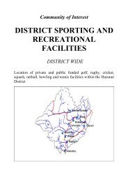
Recreation, Visitor Attractions, Parks<br />
and Reserves<br />
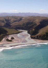
The <strong>Hurunui</strong> is one of the few places in New Zealand’s South<br />
Island that in less than two hours traveling time, you can drive<br />
from the Lewis Pass (the northern most point of the Southern<br />
Alps) with its fresh mountain air, spectacular scenery and lush<br />
beech forests, to be sitting by the coast watching the waves<br />
from the Pacific Ocean crash onto the Beach. Activities<br />
include mountain walks, skiing, thermal bathing, river sports<br />
and recreation, surfing, fishing and spectacular walks amidst<br />
salt stone cliffs on our secluded beaches. The Waipara Valley is<br />
renowned for some of New Zealand’s award winning wines, and<br />
this area offers the opportunity to discover many fine vineyards.<br />
The <strong>Hurunui</strong> has over 270 hectares of passive and recreation<br />
reserves including the world famous Hanmer Springs Thermal<br />
Pools and Spa. A significant recent addition is the former Queen<br />
Mary Hospital grounds in Hanmer Springs. The main beaches<br />
are at Leithfield, Amberley, Motunau and Gore Bay. The main<br />
recreational lakes are Lake Sumner, Lake Taylor and Lake<br />
Tennyson.<br />
Main Industries<br />
The <strong>Hurunui</strong> is continuing to experience growth and<br />
diversification in terms of industry. Historically the district<br />
has been primarily agriculture based, and this still continues<br />
to be the single largest contributor to the <strong>Hurunui</strong> economy.<br />
However, recent times have seen an expansion in both viticulture<br />
and tourism. The growth of Hanmer Springs, the district icon,<br />
as a tourist destination and the establishment of associated<br />
infrastructure, is unprecedented in the tourism sector New<br />
Zealand wide. The majority of the district’s working population<br />
are employed in the “agriculture, forestry or fishing” industries<br />
(as defined by Statistics NZ). The second largest employment<br />
industry category is “accommodation, cafes and restaurants”,<br />
followed by “health and community services”.<br />
Agri/Viticulture<br />
According to the 2007 Statistics New Zealand Agricultural<br />
Production Census, the <strong>Hurunui</strong> <strong>District</strong> is home to 1,065 farms,<br />
462 of which are sheep farms (total of 1,612,116 sheep), and<br />
130 of which are beef cattle farms (with 119,141 cattle). 53,099<br />
dairy cattle and 34,042 deer were counted in the <strong>Hurunui</strong><br />
<strong>District</strong>. The major horticultural activities in the <strong>District</strong> are<br />
grape-growing (970 hectares), followed by olives (87 hectares)<br />
and hazelnuts (25 hectares). There is a small vegetable harvest<br />
in the <strong>Hurunui</strong> <strong>District</strong> (e.g. asparagus), and we produced 9,679<br />
tonnes of barley, 3,852 tonnes of wheat, and 556 tonnes of field/<br />
seed peas during the year ended 30 June 2007.<br />
Development and Growth<br />
The <strong>Hurunui</strong> <strong>District</strong> has a highly diversified economy based<br />
around agriculture, viticulture and tourism. Both domestic<br />
and international tourism have increased significantly over the<br />
past decade in recognition of the wide array of recreational<br />
opportunities within <strong>Hurunui</strong> from the coast to the mountains.<br />
The Hanmer Springs Thermal Pools & Spa, Mt Lyford Ski Field<br />
and Waipara wine producing area are recognised as anchor<br />
destinations that have been a catalyst for business investment in<br />
the <strong>District</strong>. Statistics New Zealand has estimated the <strong>Hurunui</strong><br />
population at 2026 to be 12,350 on a medium growth projection.<br />
However because of a large absentee population owning<br />
lifestyle and holiday homes, the <strong>Council</strong> is planning for growth<br />
demands based upon trends in subdivision developments, and,<br />
upon this basis, indications are that district wide growth will<br />
be slower than what is indicated by the Statistics New Zealand<br />
projections, but the Amberley and Hanmer Springs Wards are<br />
more likely to be at the medium or even high growth rates.<br />
Health<br />
Indicators of health in the <strong>District</strong> include the Ministry of<br />
Health’s “Deprivation Index”, which has been shown to correlate<br />
with various health statistics (e.g. rates of cervical cancer,<br />
mental health problems). This index assigns deprivation scores<br />
(1 least deprived, to 10 most deprived) to each meshblock in<br />
New Zealand. Meshblocks are geographical units defined by<br />
Statistics New Zealand (containing a median of approximately<br />
87 people in 2006). Scores are based on variables like income,<br />
home ownership, unemployment, qualifications, household<br />
crowding, transportation, and access to telecomunications.<br />
These scores are assigned as measures of relative (rather than<br />
absolute) deprivation. Thus, 10% of meshblocks in New Zealand<br />
as a whole will always score 10. Scores for the <strong>Hurunui</strong> <strong>District</strong><br />
indicate much lower than average deprivation, with more than<br />
75 % of meshblocks scoring in the top half (see graph on page 14).<br />
Lower than average levels of income and education in Amberley,<br />
and lower than average home ownership in Hanmer Springs<br />
(due to holiday and workers’ accommodation) contributed to<br />
higher than expected scores for these areas (both 7).<br />
49