- Page 1: Christchurch and East Dorset Counci
- Page 4: Core Strategy OptionsWelcome.1 Welc
- Page 7 and 8: Core Strategy Options1.18 We want t
- Page 9 and 10: Core Strategy Optionsemployment pre
- Page 11 and 12: Core Strategy OptionsClimate Change
- Page 13 and 14: Core Strategy Options2.24 The propo
- Page 15 and 16: Core Strategy Options2.44 Future re
- Page 17 and 18: Core Strategy OptionsTown Centres2.
- Page 20 and 21: Core Strategy OptionsSummary of Key
- Page 22 and 23: Core Strategy Options3.7 Spatial pl
- Page 24 and 25: Core Strategy Options3.19 These bro
- Page 26 and 27: Core Strategy Optionsvolunteering,
- Page 28 and 29: Core Strategy Optionsthe Strategic
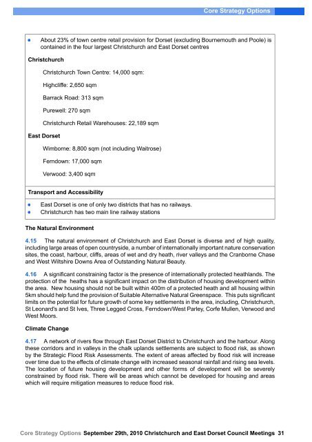
- Page 30 and 31: Core Strategy Options4 The Key Stra
- Page 34 and 35: Core Strategy Options4.18 Resisting
- Page 36 and 37: Core Strategy Options4.34 Town Cent
- Page 38 and 39: Core Strategy OptionsWhere are we n
- Page 40 and 41: Core Strategy OptionsPreferred Opti
- Page 42 and 43: Core Strategy OptionsWhy is it the
- Page 44 and 45: Core Strategy OptionsThe option is
- Page 46 and 47: Core Strategy OptionsDoes it confor
- Page 48 and 49: Core Strategy OptionsChapter 9: Cor
- Page 50 and 51: Core Strategy OptionsOption KS 9Chr
- Page 52 and 53: Core Strategy OptionsOption KS 11Ch
- Page 54 and 55: Core Strategy OptionsThe Christchur
- Page 56 and 57: Core Strategy OptionsPreferred Opti
- Page 58 and 59: Core Strategy OptionsThe capacity o
- Page 60 and 61: Core Strategy OptionsJoint Retail A
- Page 62 and 63: Core Strategy OptionsPreferred Opti
- Page 64 and 65: Core Strategy OptionsStrategic Tran
- Page 66 and 67: Core Strategy OptionsPreferred Opti
- Page 68 and 69: Core Strategy OptionsIs it informed
- Page 70 and 71: Core Strategy OptionsWhy is it the
- Page 72 and 73: Core Strategy OptionsNeed to improv
- Page 74 and 75: Core Strategy OptionsRetail uses wi
- Page 76 and 77: Core Strategy OptionsSaxon Square w
- Page 78 and 79: Core Strategy OptionsPreferred Opti
- Page 80 and 81: Core Strategy Optionsfuture retail
- Page 82 and 83:
Core Strategy OptionsNon Preferred
- Page 84 and 85:
Core Strategy OptionsNon Preferred
- Page 86 and 87:
Core Strategy OptionsTransport5.28
- Page 88 and 89:
Core Strategy OptionsNationalYesLoc
- Page 90 and 91:
Core Strategy Options6 Christchurch
- Page 92 and 93:
Core Strategy OptionsInfrastructure
- Page 94 and 95:
Core Strategy Options6.12 There are
- Page 96 and 97:
Core Strategy OptionsConclusion: Th
- Page 98 and 99:
Core Strategy OptionsThe strategy f
- Page 100 and 101:
Core Strategy OptionsTypes of open
- Page 102 and 103:
Core Strategy OptionsNorth Christch
- Page 104 and 105:
Core Strategy OptionsIn accordance
- Page 106 and 107:
Core Strategy OptionsOption UE 3Loc
- Page 108 and 109:
Core Strategy OptionsThis option in
- Page 110 and 111:
Core Strategy OptionsCommunity / Vi
- Page 112 and 113:
Core Strategy Options7 Bournemouth
- Page 114 and 115:
Core Strategy OptionsAirport develo
- Page 116 and 117:
Core Strategy OptionsParts of the N
- Page 118 and 119:
Core Strategy Options7.36 The Airpo
- Page 120 and 121:
Core Strategy OptionsLandscaping7.4
- Page 122 and 123:
Core Strategy OptionsPreferred Opti
- Page 124 and 125:
Core Strategy OptionsThis option ma
- Page 126 and 127:
Core Strategy OptionsBournemouth Ai
- Page 128 and 129:
Core Strategy OptionsTransport mode
- Page 130 and 131:
Core Strategy OptionsSouth East Dor
- Page 132 and 133:
Core Strategy OptionsIncreased leve
- Page 134 and 135:
Core Strategy Options8 Wimborne and
- Page 136 and 137:
Core Strategy Options8.18 Employmen
- Page 138 and 139:
Core Strategy Options8.39 Where sho
- Page 140 and 141:
Core Strategy Options8.57 A major f
- Page 142 and 143:
Core Strategy Options1. Land north
- Page 144 and 145:
Core Strategy Options8.76 Refined A
- Page 146 and 147:
Core Strategy Options1. The narrowe
- Page 148 and 149:
Core Strategy OptionsRelocated rugb
- Page 150 and 151:
Core Strategy OptionsThe option cou
- Page 152 and 153:
Core Strategy OptionsDoes it confor
- Page 154 and 155:
Core Strategy OptionsWhy is it an O
- Page 156 and 157:
Core Strategy OptionsNationalYesLoc
- Page 158 and 159:
Core Strategy OptionsNon Preferred
- Page 160 and 161:
Core Strategy OptionsDoes it confor
- Page 162 and 163:
Core Strategy OptionsWhy is it an O
- Page 164 and 165:
Core Strategy Options9.10 The villa
- Page 166 and 167:
Core Strategy Options9.25 For suppo
- Page 168 and 169:
Core Strategy OptionsEnvironment: P
- Page 170 and 171:
Core Strategy Options9.60 Refined A
- Page 172 and 173:
Core Strategy Optionsfor developmen
- Page 174 and 175:
Core Strategy Options9.80 Progress
- Page 176 and 177:
Core Strategy OptionsThe option pro
- Page 178 and 179:
Core Strategy OptionsThe East Dorse
- Page 180 and 181:
Core Strategy Optionsareas suitable
- Page 182 and 183:
Core Strategy OptionsProtecting the
- Page 184 and 185:
Core Strategy Options10.50 The opti
- Page 186 and 187:
Core Strategy Options10.68 Environm
- Page 188 and 189:
Core Strategy OptionsSANGs (between
- Page 190 and 191:
Core Strategy Options10.83 Land nor
- Page 192 and 193:
Core Strategy OptionsThis is a good
- Page 194 and 195:
Core Strategy OptionsThe option off
- Page 196 and 197:
Core Strategy OptionsDoes it confor
- Page 198 and 199:
Core Strategy OptionsNon Preferred
- Page 200 and 201:
Core Strategy OptionsIs it informed
- Page 202 and 203:
Core Strategy Options11.10 Existing
- Page 204 and 205:
Core Strategy Options11.27 National
- Page 206 and 207:
Core Strategy Options11.57 The area
- Page 208 and 209:
Core Strategy Options5. The area wi
- Page 210 and 211:
Core Strategy Options11.87 Landscap
- Page 212 and 213:
Core Strategy OptionsMix of house t
- Page 214 and 215:
Core Strategy OptionsOption VWM 2De
- Page 216 and 217:
Core Strategy OptionsThe developmen
- Page 218 and 219:
Core Strategy OptionsThe East Dorse
- Page 220 and 221:
Core Strategy OptionsPreferred Opti
- Page 222 and 223:
Core Strategy OptionsWhy is it the
- Page 224 and 225:
Core Strategy OptionsPreferred Opti
- Page 226 and 227:
Core Strategy OptionsSupport the pr
- Page 228 and 229:
Core Strategy OptionsPreferred Opti
- Page 230 and 231:
Core Strategy OptionsThis option wi
- Page 232 and 233:
Core Strategy OptionsPreferred Opti
- Page 234 and 235:
Core Strategy Options12.18 All new
- Page 236 and 237:
Core Strategy OptionsDevelopments i
- Page 238 and 239:
Core Strategy OptionsPreferred Opti
- Page 240 and 241:
Core Strategy OptionsPreferred Opti
- Page 242 and 243:
Core Strategy OptionsThe Christchur
- Page 244 and 245:
Core Strategy OptionsWhy is it Pref
- Page 246 and 247:
Core Strategy Options13.7 Dorset, C
- Page 248 and 249:
Core Strategy OptionsChristchurch C
- Page 250 and 251:
Core Strategy Options13.24 East Dor
- Page 252 and 253:
Core Strategy OptionsThis is suppor
- Page 254 and 255:
Core Strategy OptionsSettlement(no
- Page 256 and 257:
Core Strategy OptionsIssue: What op
- Page 258 and 259:
Core Strategy OptionsPreferred Opti
- Page 260 and 261:
Core Strategy OptionsWhy is it a Pr
- Page 262 and 263:
Core Strategy OptionsNon Preferred
- Page 264 and 265:
Core Strategy OptionsKey FactsIn-mi
- Page 266 and 267:
Core Strategy OptionsNon Preferred
- Page 268 and 269:
Core Strategy OptionsDraft London H
- Page 270 and 271:
Core Strategy OptionsChristchurch C
- Page 272 and 273:
Core Strategy OptionsDorset Authori
- Page 274 and 275:
Core Strategy OptionsKey facts473 s
- Page 276 and 277:
Core Strategy OptionsChristchurch a
- Page 278 and 279:
Core Strategy OptionsWhy is it non
- Page 280 and 281:
Core Strategy OptionsPreferred Opti
- Page 282 and 283:
Core Strategy OptionsWhilst some st
- Page 284 and 285:
Core Strategy OptionsOlder people s
- Page 286 and 287:
Core Strategy OptionsThe option wou
- Page 288 and 289:
Core Strategy OptionsEnsure local b
- Page 290 and 291:
Core Strategy Optionsshops and faci
- Page 292 and 293:
Core Strategy OptionsPreferred Opti
- Page 294 and 295:
Core Strategy OptionsThis option do
- Page 296 and 297:
Core Strategy OptionsOption PC 420
- Page 298 and 299:
Core Strategy OptionsOption PC 59.7
- Page 300 and 301:
Core Strategy OptionsOption PC 63.3
- Page 302 and 303:
Core Strategy OptionsOption PC 76 h
- Page 304 and 305:
Core Strategy OptionsNon Preferred
- Page 306 and 307:
Core Strategy OptionsNon Preferred
- Page 308 and 309:
Core Strategy OptionsPreferred Opti
- Page 310 and 311:
Core Strategy OptionsPreferred Opti
- Page 312 and 313:
Core Strategy OptionsAlternative Pr
- Page 314 and 315:
Core Strategy Options15.43 Issue: H
- Page 316 and 317:
Core Strategy OptionsThe Options15.
- Page 318 and 319:
Core Strategy Options16.6 LocalThe
- Page 320 and 321:
Core Strategy OptionsNon Preferred
- Page 322 and 323:
Core Strategy Options17 Monitoring
- Page 324 and 325:
Core Strategy Options4 KeyStrategyK
- Page 326 and 327:
Core Strategy Optionseast andwest o
- Page 328 and 329:
Core Strategy OptionsGreenspacerequ
- Page 330 and 331:
Core Strategy Options11 Verwoodand
- Page 332 and 333:
Core Strategy Optionsresidentialwit
- Page 334 and 335:
Core Strategy Optionsproposed toena
- Page 336 and 337:
Core Strategy Optionsmarket ,reduce
- Page 338 and 339:
Core Strategy Options13 CreatingHig
- Page 340 and 341:
Core Strategy Options12Managingthe
- Page 342 and 343:
Core Strategy OptionsWorkspaceStrat
- Page 344 and 345:
Core Strategy Options15 CreatingPro
- Page 346 and 347:
Core Strategy Optionspowercablesund
- Page 348 and 349:
Core Strategy Options9 CorfeMullenH
- Page 350 and 351:
Core Strategy OptionsSchool.Provisi
- Page 352 and 353:
Core Strategy Optionsrural andurban
- Page 354 and 355:
Core Strategy OptionsA348 BearCross
- Page 356 and 357:
Core Strategy Optionsis requiredto
- Page 358 and 359:
Core Strategy OptionsOtherstrategic
- Page 360 and 361:
Core Strategy Options7BournemouthAi
- Page 362 and 363:
Core Strategy Options10Ferndownand
- Page 364 and 365:
Core Strategy Options6ChristchurchU
- Page 366 and 367:
Core Strategy Options9 CorfeMullenH