


You also want an ePaper? Increase the reach of your titles
YUMPU automatically turns print PDFs into web optimized ePapers that Google loves.
20 Chapter 1: Nor<strong>the</strong>rn Howgills and Orton Fells<br />
Walk 1: A Circuit <strong>of</strong> Bowderdale, including Green Bell<br />
Map: OL19 (please read <strong>the</strong> general note about <strong>the</strong> walks in <strong>the</strong> Introduction).<br />
Starting point: Near Wath on <strong>the</strong> road south <strong>of</strong> <strong>the</strong> A685 (685050).<br />
<strong>The</strong>re are three obvious routes between Bowderdale Foot and <strong>the</strong> head <strong>of</strong> Bowderdale – <strong>the</strong> west ridge, <strong>the</strong> east ridge, and<br />
<strong>the</strong> valley bottom. Higher ma<strong>the</strong>matics shows that <strong>the</strong>re are six loops possible.<br />
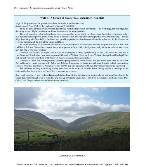
<strong>The</strong> walk along <strong>the</strong> valley bottom should be experienced, but not on a first visit. Impressive though <strong>the</strong> symmetrical valley<br />
is, it becomes claustrophobic after a while. <strong>The</strong>re is only one view and only <strong>the</strong> odd sheepfold to break <strong>the</strong> monotony. <strong>The</strong> west<br />
ridge, beginning with West Fell, is <strong>the</strong> better one, providing good views into Bowderdale and Langdale and, in <strong>the</strong> distance, an<br />
evolving panorama <strong>of</strong> <strong>the</strong> hills <strong>of</strong> <strong>the</strong> Lakes and Dales.<br />
So begin by setting <strong>of</strong>f southwest, past Brow Foot, to Bowderdale Foot and <strong>the</strong>n onto <strong>the</strong> footpath that leads to West Fell<br />
and Hazelgill Knott. You will meet many sheep, a few ponies perhaps, and, only if you are really lucky (or unlucky, as <strong>the</strong> case<br />
may be), one or two o<strong>the</strong>r walkers.<br />
Continue 2km south <strong>of</strong> Hazelgill Knott and, as <strong>the</strong> path begins to swing right (heading for <strong>The</strong> Calf), leave it to turn east to<br />
Hare Shaw and Bowderdale Head to <strong>the</strong> unnamed hill south <strong>of</strong> Yarlside. Head north over Yarlside, Kensgriff and Randygill Top,<br />
with distant views <strong>of</strong> Cross Fell, Wild Boar Fell, Ingleborough and <strong>the</strong> Lakes skyline.<br />
Continue to Green Bell, where you may locate <strong>the</strong> spring that is <strong>the</strong> source <strong>of</strong> <strong>the</strong> <strong>Lune</strong>, just below some ruins <strong>of</strong>f <strong>the</strong> Green<br />
Bell to Knoutberry path. As you wish, follow <strong>the</strong> fledgling <strong>Lune</strong> down or, better, <strong>the</strong> path over Stwarth, in both cases cutting<br />
across to Weasdale and <strong>the</strong>nce to Wath (just follow <strong>the</strong> OS map through gates and fields: <strong>the</strong>re are few reassuring signposts).<br />
<strong>The</strong> distances are long but walking is easy apart from on <strong>the</strong> slopes <strong>of</strong> Yarlside. Route finding may be a challenge on <strong>the</strong><br />
eastern ridge but <strong>the</strong> trig point on Green Bell is a reassuring presence.<br />
Short walk variation: A short walk up Bowderdale is hardly possible without tackling its steep slopes, so instead head directly for<br />
Green Bell. Walk through Gars to Weasdale and <strong>the</strong>n up Stwarth to Green Bell. <strong>The</strong>n, from <strong>the</strong> source <strong>of</strong> <strong>the</strong> <strong>Lune</strong>, follow Dale<br />
Gill to Dale Tongue and cut over to Weasdale and <strong>the</strong>n back.<br />
Looking up Bowderdale<br />
This is Chapter 1 <strong>of</strong> <strong>The</strong> <strong>Land</strong> <strong>of</strong> <strong>the</strong> <strong>Lune</strong> (2nd edition), http://www.drakkar.co.uk/land<strong>of</strong><strong>the</strong>lune.html, Copyright © 2010 John Self

