


Create successful ePaper yourself
Turn your PDF publications into a flip-book with our unique Google optimized e-Paper software.
40 Chapter 2: Shap Fells and Birkbeck Fells<br />
Borrow Beck<br />
Borrow Beck runs for 10km east from between<br />
High House Fell and Bannisdale Fell through<br />
Borrowdale, <strong>the</strong> most beautiful valley in Loyne despite<br />
being split in two by <strong>the</strong> A6. Upper Borrowdale is within<br />
<strong>the</strong> Lake District National Park and has some <strong>of</strong> <strong>the</strong><br />
character <strong>of</strong> Lakeland valleys. Unfortunately, <strong>the</strong>re is<br />
no footpath in upper Borrowdale, which <strong>the</strong>refore can<br />
only be appreciated by walking <strong>the</strong> long, grassy ridges<br />
on ei<strong>the</strong>r side.<br />
Just below High Borrow Bridge, Crookdale Beck<br />
joins Borrow Beck. This junction illustrates <strong>the</strong> difficulty<br />
<strong>of</strong> determining <strong>the</strong> source <strong>of</strong> a watercourse. Upper and<br />
lower Borrowdale are aligned so well that it seems<br />
obvious that <strong>the</strong> same beck, Borrow Beck, flows through<br />
<strong>the</strong>m both. But Crookdale Beck has a much higher and<br />
more distant source, below Harrop Pike (637m), than<br />
Borrow Beck and at <strong>the</strong> junction ought to be regarded as<br />
<strong>the</strong> senior partner.<br />
Perhaps aes<strong>the</strong>tics play a part because Crookdale<br />
is such a dreary valley that no beck would want to be<br />
born <strong>the</strong>re. <strong>The</strong>re are twelve million visits to <strong>the</strong> Lake<br />
District National Park each year and approximately none<br />
<strong>of</strong> <strong>the</strong>m involve an outing to Crookdale. Above Hause<br />
Foot, <strong>the</strong>re is little <strong>of</strong> interest to a visitor not fascinated<br />
by varieties <strong>of</strong> grass and herb, only <strong>the</strong> modest crags <strong>of</strong><br />
Great Yarlside breaking <strong>the</strong> monotonous, peaty slopes.<br />
Hause Foot is on <strong>the</strong> turnpike route before <strong>the</strong> A6<br />
was built in <strong>the</strong> 1820s. A steep curve up <strong>the</strong> nor<strong>the</strong>rn<br />
slope can be traced, reaching 440m, with <strong>the</strong> route<br />
continuing north over Packhorse Hill and south to High<br />
Borrow Bridge. This route played a key part in <strong>the</strong> 1745<br />
incursion <strong>of</strong> Bonnie Prince Charlie. When his army<br />
began to retreat, bridges such as High Borrow Bridge<br />
were demolished ahead <strong>of</strong> it to hamper its struggle over<br />
<strong>the</strong> Shap summit, after which <strong>the</strong> Scottish army was<br />
defeated in its last battle on English soil.<br />
In a lay-by on <strong>the</strong> A6 <strong>the</strong>re is a memorial to drivers<br />
over <strong>the</strong> A6 Shap summit, but <strong>the</strong> A6 is far from forgotten<br />
and unused today. <strong>The</strong>re is no memorial to <strong>the</strong> souls<br />
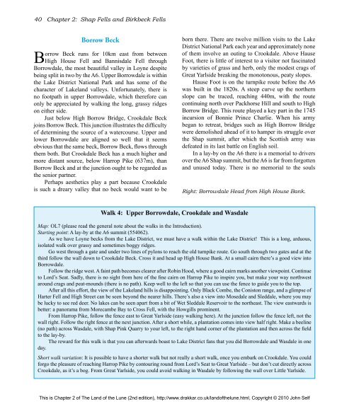
Right: Borrowdale Head from High House Bank.<br />
Walk 4: Upper Borrowdale, Crookdale and Wasdale<br />
Map: OL7 (please read <strong>the</strong> general note about <strong>the</strong> walks in <strong>the</strong> Introduction).<br />
Starting point: A lay-by at <strong>the</strong> A6 summit (554062).<br />
As we have Loyne becks from <strong>the</strong> Lake District, we must have a walk within <strong>the</strong> Lake District! This is a long, arduous,<br />
isolated walk over grassy and sometimes boggy ridges.<br />
Go west through a gate and under two lines <strong>of</strong> pylons to reach <strong>the</strong> old turnpike route. Go south through two gates and at <strong>the</strong><br />
third follow <strong>the</strong> wall down to Crookdale Beck. Cross it and head up High House Bank. At a small cairn <strong>the</strong>re’s a good view into<br />
Borrowdale.<br />
Follow <strong>the</strong> ridge west. A faint path becomes clearer after Robin Hood, where a good cairn marks ano<strong>the</strong>r viewpoint. Continue<br />
to Lord’s Seat. Sadly, <strong>the</strong>re is no sight from here <strong>of</strong> <strong>the</strong> fine cairn on Harrop Pike to inspire you, but make your way northwest<br />
around crags and peat-mounds (<strong>the</strong>re is no path). Keep well to <strong>the</strong> left so that you can use <strong>the</strong> fence to guide you to <strong>the</strong> top.<br />
After all this effort, <strong>the</strong> view <strong>of</strong> <strong>the</strong> Lakeland hills is disappointing. Only Black Combe, <strong>the</strong> Coniston range, and a glimpse <strong>of</strong><br />
Harter Fell and High Street can be seen beyond <strong>the</strong> nearer hills. <strong>The</strong>re’s also a view into Mosedale and Sleddale, where you may<br />
be lucky to see red deer. No lakes can be seen apart from a bit <strong>of</strong> Wet Sleddale Reservoir to <strong>the</strong> nor<strong>the</strong>ast. <strong>The</strong> view eastwards is<br />
better: a panorama from Morecambe Bay to Cross Fell, with <strong>the</strong> Howgills prominent.<br />
From Harrop Pike, follow <strong>the</strong> fence east to Great Yarlside (easy walking here). At <strong>the</strong> junction follow <strong>the</strong> fence left, not <strong>the</strong><br />
wall right. Follow <strong>the</strong> right fence at <strong>the</strong> next junction. After a short while, a plantation comes into view half right. Make a beeline<br />
(no path) across Wasdale, with Shap Pink Quarry to your left, to <strong>the</strong> right hand corner <strong>of</strong> <strong>the</strong> plantation and <strong>the</strong>n across <strong>the</strong> field<br />
to <strong>the</strong> lay-by.<br />
<strong>The</strong> reward for this walk is that you can afterwards boast to Lake District fans that you did Borrowdale and Wasdale in one<br />
day.<br />
Short walk variation: It is possible to have a shorter walk but not really a short walk, once you embark on Crookdale. You could<br />
forgo <strong>the</strong> pleasure <strong>of</strong> reaching Harrop Pike by contouring round from Lord’s Seat to Great Yarlside – but don’t cut directly across<br />
Crookdale, as it’s a bog. From Great Yarlside, you could avoid walking in Wasdale by following <strong>the</strong> wall over Little Yarlside.<br />
This is Chapter 2 <strong>of</strong> <strong>The</strong> <strong>Land</strong> <strong>of</strong> <strong>the</strong> <strong>Lune</strong> (2nd edition), http://www.drakkar.co.uk/land<strong>of</strong><strong>the</strong>lune.html, Copyright © 2010 John Self

