NUI Galway – UL Alliance First Annual ENGINEERING AND - ARAN ...
NUI Galway – UL Alliance First Annual ENGINEERING AND - ARAN ...
NUI Galway – UL Alliance First Annual ENGINEERING AND - ARAN ...

You also want an ePaper? Increase the reach of your titles
YUMPU automatically turns print PDFs into web optimized ePapers that Google loves.
Assessing the contribution of monitoring and modelling data to water quality<br />
mapping estimation error<br />
Joseph V. McGovern, Dr. Michael Hartnett<br />
Civil Engineering Department, Environmental Informatics, Ryan Institute<br />
j.mcgovern1@nuigalway.ie; michael.hartnett@nuigalway.ie<br />
Abstract<br />
The Water Framework Directive (WFD) (EC 2000)<br />
sets the primary objective that all water bodies will<br />
achieve a minimum of “good” status by 2015. Limited<br />
guidance is available at present for assembly of<br />
monitoring programmes for the WFD. Bayesian<br />
Maximum Entropy incorporates monitoring data and<br />
model data, enabling accurate maps to be generated<br />
without the requirement for intensive monitoring<br />
campaigns. The author intends to utilise a number of<br />
approaches with BME to assist in optimisation of<br />
monitoring programmes. Here, an assessment is made<br />
of the relative contribution of monitoring and model<br />
output to the lowering of mapping estimation error.<br />
1. Introduction<br />
Monitoring programme guidance provided under the<br />
Common Implementation Strategy for the WFD lacks a<br />
rigorous methodology. Advice relating to WFD<br />
monitoring programmes is provided in the areas of<br />
monitoring point location and quantity and sampling<br />
frequency. Suggestions include grouping of waterbodies<br />
with similar natural conditions/anthropogenic pressures,<br />
increasing the density of sampling in space & time to<br />
counteract high heterogeneity and locating monitoring<br />
points at the most sensitive locations. Statistical<br />
assistance is limited to approximating the number of<br />
monitoring points for a desired confidence level &<br />
precision. (Commission 2003)<br />
2. Sparse data and Bayesian Maximum<br />
Entropy<br />
Sparse data availability limits the understanding of<br />
water quality processes and causations. Normal<br />
mapping interpolation of monitoring data via<br />
simple/ordinary kriging would result in maps of limited<br />
use unless a high number of monitoring points were<br />
sampled for mapping, which would prove costly. BME<br />
incorporates information such as measured field data<br />
and model output to generate grid mean estimates. BME<br />
allows the determination of the probability that the<br />
variable under examination will be above an<br />
environmental quality standard. BME presents an<br />
opportunity to improve uncertainty in water quality<br />
estimates and assess the efficacy of existing & proposed<br />
monitoring programmes, both in terms of cost &<br />
144<br />
sufficiency of estimation uncertainty(Joseph N.<br />
LoBuglio 2007). BME involves two main stages: the<br />
prior and posterior. The prior stage assembles a general<br />
knowledge based pdf fg which describes the likely range<br />
of values throughout the domain covered by<br />
monitoring/model results. The posterior stage integrates<br />
the domain pdf with adjacent data to give a pdf of the<br />
estimation points in question (Christakos 2000).<br />
4. Results<br />
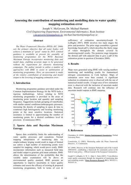
Maps were generated using BME with varying numbers<br />
monitoring and modelling results for Ammoniacal<br />
nitrogen concentrations in Cork harbour. Maps of<br />
estimation error were then created. A significant<br />
reduction in estimation error is observed with the use of<br />
numerical model results. A larger area of low estimation<br />
error is observed with the inclusion of uncertain model<br />
data. Research will continue into the influence of<br />
uncertain model outputs in BME mapping.<br />
5. References<br />
Christakos, G. (2000). Modern Spatiotemporal Geostatistics,<br />
Oxford<br />
University Press.<br />
Commission, E. (2003). Monitoring under the Water Framework<br />
Directive. . E. Commission.<br />
EC (2000). Directive of the European Parliament and of the Council<br />
2000/60/EC, establishing a framework for community action in the<br />
field of water policy. . Official Journal of the European Communities.<br />
Joseph N. LoBuglio, G. W. C., Marc L. Serre (2007). "Cost-effective<br />
water quality assessment through the integration of monitoring data<br />
and modelling results." Water Resources Research 43(3): W03435.1-<br />
W03435.16.