climate change on UAE - Stockholm Environment Institute-US Center
climate change on UAE - Stockholm Environment Institute-US Center
climate change on UAE - Stockholm Environment Institute-US Center

Create successful ePaper yourself
Turn your PDF publications into a flip-book with our unique Google optimized e-Paper software.
Impacts, Vulnerability & Adaptati<strong>on</strong> for<br />
Coastal Z<strong>on</strong>es in the United Arab Emirates<br />
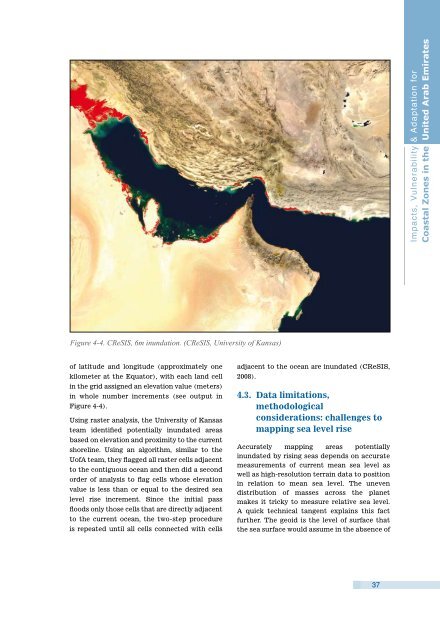
Figure 4-4. CReSIS, 6m inundati<strong>on</strong>. (CReSIS, University of Kansas)<br />
of latitude and l<strong>on</strong>gitude (approximately <strong>on</strong>e<br />
kilometer at the Equator), with each land cell<br />
in the grid assigned an elevati<strong>on</strong> value (meters)<br />
in whole number increments (see output in<br />
Figure 4-4).<br />
Using raster analysis, the University of Kansas<br />
team identified potentially inundated areas<br />
based <strong>on</strong> elevati<strong>on</strong> and proximity to the current<br />
shoreline. Using an algorithm, similar to the<br />
UofA team, they flagged all raster cells adjacent<br />
to the c<strong>on</strong>tiguous ocean and then did a sec<strong>on</strong>d<br />
order of analysis to flag cells whose elevati<strong>on</strong><br />
value is less than or equal to the desired sea<br />
level rise increment. Since the initial pass<br />
floods <strong>on</strong>ly those cells that are directly adjacent<br />
to the current ocean, the two-step procedure<br />
is repeated until all cells c<strong>on</strong>nected with cells<br />
adjacent to the ocean are inundated (CReSIS,<br />
2008).<br />
4.3. Data limitati<strong>on</strong>s,<br />
methodological<br />
c<strong>on</strong>siderati<strong>on</strong>s: challenges to<br />
mapping sea level rise<br />
Accurately mapping areas potentially<br />
inundated by rising seas depends <strong>on</strong> accurate<br />
measurements of current mean sea level as<br />
well as high-resoluti<strong>on</strong> terrain data to positi<strong>on</strong><br />
in relati<strong>on</strong> to mean sea level. The uneven<br />
distributi<strong>on</strong> of masses across the planet<br />
makes it tricky to measure relative sea level.<br />
A quick technical tangent explains this fact<br />
further. The geoid is the level of surface that<br />
the sea surface would assume in the absence of<br />
37