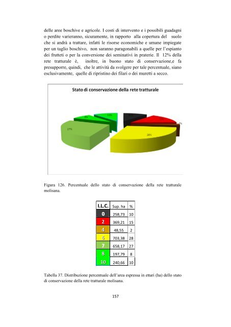
delle aree boschive e agricole. I costi <strong>di</strong> <strong>in</strong>tervento e i possibili guadagni o per<strong>di</strong>te varieranno, sicuramente, <strong>in</strong> rapporto al<strong>la</strong> copertura del suolo che si andrà a trattare, <strong>in</strong>fatti le risorse economiche e umane impiegate per un taglio boschivo, non saranno paragonabili a quelle per l‟espianto <strong>dei</strong> frutteti o per <strong>la</strong> conversione <strong>dei</strong> sem<strong>in</strong>ativi <strong>in</strong> praterie. Il 12% del<strong>la</strong> <strong>rete</strong> tratturale è, <strong>in</strong>oltre, <strong>in</strong> buono <strong>stato</strong> <strong>di</strong> <strong>conservazione</strong>,e fa presupporre, qu<strong>in</strong><strong>di</strong>, che le attività da svolgere per tale percentuale, siano esclusivamente, quelle <strong>di</strong> riprist<strong>in</strong>o <strong>dei</strong> fi<strong>la</strong>ri o <strong>dei</strong> muretti a secco. Figura 126. Percentuale <strong>dello</strong> <strong>stato</strong> <strong>di</strong> <strong>conservazione</strong> del<strong>la</strong> <strong>rete</strong> tratturale molisana. I.L.C. Sup. ha % 0 258,73 10 2 369,21 15 4 48,55 2 6 703,38 28 7 658,17 27 8 197,79 8 10 240,66 10 Tabel<strong>la</strong> 37. Distribuzione percentuale dell‟area espressa <strong>in</strong> ettari (ha) <strong>dello</strong> <strong>stato</strong> <strong>di</strong> <strong>conservazione</strong> del<strong>la</strong> <strong>rete</strong> tratturale molisana. 157
Per meglio qualificare <strong>la</strong> <strong>rete</strong> tratturale ed <strong>in</strong><strong>di</strong>viduare le aree <strong>di</strong> <strong>in</strong>tervento per il suo riprist<strong>in</strong>o, i dati <strong>dello</strong> <strong>stato</strong> <strong>di</strong> <strong>conservazione</strong>, sono stati associati a quelli altimetrici ed è emersa <strong>la</strong> seguente situazione: <strong>la</strong> <strong>rete</strong> tratturale, nel<strong>la</strong> zona <strong>di</strong> pianura, è marcatamente rappresentata da un valore <strong>di</strong> <strong>conservazione</strong> pari a sette, mentre, è totalmente assente lo <strong>stato</strong> <strong>di</strong> <strong>conservazione</strong> ottimale; ciò, <strong>in</strong> quanto, le aree <strong>di</strong> pianura sono più facilmente accessibili alle attività agricole e a quelle antropiche. Abbiamo, <strong>in</strong>fatti, una percentuale del 62% a sem<strong>in</strong>ativi e circa il 14% <strong>di</strong> tratturo completamente perso. Nelle aree coll<strong>in</strong>ari, a <strong>di</strong>fferenza <strong>di</strong> quelle <strong>di</strong> pianura,<strong>in</strong>izia a farsi vedere il tratturo <strong>in</strong> ottimo <strong>stato</strong> <strong>di</strong> <strong>conservazione</strong> (12%) e <strong>in</strong> buono <strong>stato</strong> <strong>di</strong> <strong>conservazione</strong> (22%), con una forte <strong>di</strong>m<strong>in</strong>uzione delle aree a sem<strong>in</strong>ativi (23%) e purtroppo, un aumento delle aree boschive, evidente m<strong>in</strong>accia <strong>dei</strong> <strong>tratturi</strong>, con il 15%. Nelle aree sub – montane, ad una quota compresa tra i 600 e i 900 m s.l.m., <strong>la</strong> situazione è quasi simile a quel<strong>la</strong> coll<strong>in</strong>are, con il tratturo ottimamente conservato (17%) e <strong>in</strong> buono <strong>stato</strong> <strong>di</strong> <strong>conservazione</strong> (25%). La zona montana, come è facile pensare, è caratterizzata da una marcata presenza <strong>di</strong> tratturo <strong>in</strong> ottimo <strong>stato</strong> <strong>di</strong> <strong>conservazione</strong>, ma anche da un‟elevata percentuale <strong>di</strong> aree boschive che aumenta <strong>la</strong> possibilità <strong>di</strong> per<strong>di</strong>ta del suolo tratturale. La <strong>rete</strong> tratturale si presenta nel suo antico splendore, completamente conservata, <strong>in</strong> due aree pr<strong>in</strong>cipali, <strong>la</strong> sub – montana e <strong>la</strong> montana, aree <strong>di</strong>fficilmente accessibili alle attività agricole e antropiche e qu<strong>in</strong><strong>di</strong> abbandonate dall‟uomo; nelle zone più facilmente percorribili, <strong>in</strong>oltre, quali <strong>la</strong> coll<strong>in</strong>are e <strong>la</strong> pianura, sussiste una scarsa o quasi totale assenza <strong>di</strong> tratturo orig<strong>in</strong>ario e una marcata predom<strong>in</strong>anza <strong>di</strong> suoli agricoli. È necessario partire da tali dati, per dare il via ad azioni efficaci, miranti al recupero ottimale <strong>dei</strong> <strong>tratturi</strong>. Gli <strong>in</strong>terventi economici devono essere sud<strong>di</strong>visi <strong>in</strong> maniera <strong>di</strong>versa, re<strong>la</strong>tivamente all‟area <strong>in</strong> cui si va ad operare. Se confrontiamo le quattro realtà altimetriche del<strong>la</strong> nostra regione, ci ren<strong>di</strong>amo conto che <strong>la</strong> spesa m<strong>in</strong>ore, riguarderebbe <strong>la</strong> zona <strong>di</strong> pianura, dove si potrebbe facilmente recuperare il 62% del<strong>la</strong> <strong>rete</strong> tratturale, convertendo i sem<strong>in</strong>ativi <strong>in</strong> praterie. L‟<strong>in</strong>vestimento economico maggiore, dovrebbe <strong>in</strong>teressare le aree montane, dove il tratturo è caratterizzato per circa il 27% da boschi, con <strong>in</strong>vestimenti, qu<strong>in</strong><strong>di</strong>, per il taglio, e successivamente, per mantenere pulita l‟area. In ultima <strong>analisi</strong>, <strong>la</strong> spesa da sostenere per le due aree <strong>in</strong>terme<strong>di</strong>e, sarebbe quasi <strong>la</strong> stessa. Ovviamente, tutti i dati raccolti, le ricerche e le e<strong>la</strong>borazioni prodotte, verrebbero vanificate <strong>in</strong> assenza <strong>di</strong> una politica seria <strong>di</strong> recupero e valorizzazione. Da tempo, <strong>in</strong> regione si par<strong>la</strong> dell‟attuazione <strong>di</strong> un “fantomatico” parco <strong>dei</strong> <strong>tratturi</strong>, che a detta <strong>dei</strong> politici locali, dovrebbe essere il punto <strong>di</strong> partenza per lo sviluppo turistico ed economico <strong>di</strong> aree bellissime che purtroppo, ancora oggi sono <strong>di</strong>menticate. Ogni anno, i comuni dell‟altissimo Molise <strong>in</strong> 158
- Page 1 and 2:
UNIVERSITÀ DEGLI STUDI DEL MOLISE
- Page 3 and 4:
1.2.6.7. Aspetti politici della tra
- Page 5 and 6:
5.1.1. Stato di conservazione tratt
- Page 7 and 8:
7.5 Quinta fase progetto di recuper
- Page 9 and 10:
castello, una torre, un centro abit
- Page 11 and 12:
ad avere un importante ruolo econom
- Page 13 and 14:
Romania si contano 2.8 milioni di b
- Page 15 and 16:
Un gregge è formato da 700 - 1.200
- Page 17 and 18:
avevano una larghezza di 100m e si
- Page 19 and 20:
“Herbassiers stabilisès” : pro
- Page 21 and 22:
pascoli invernali, posti vicino all
- Page 23 and 24:
iduce a 20. Le Canadas meglio conse
- Page 25 and 26:
convenzione di Losanna del 1923, ne
- Page 27 and 28:
1.2.5.3. Un caso studio Un caso ecl
- Page 29 and 30:
La transumanza italiana ha le segue
- Page 31 and 32:
il butteracchio (ragazzo, coadiutor
- Page 33 and 34:
1.2.6.1. La Transumanza in Molise I
- Page 35 and 36:
ultime, subirono molto l‟influenz
- Page 37 and 38:
C. di Sangro - Lucera 1.2.6.4.I Tra
- Page 39 and 40:
Bisaccia e San Martino in Pensilis.
- Page 41 and 42:
Decreto Presidente Repubblica 24 lu
- Page 43 and 44:
2. Materiali e Metodi Materiali: ma
- Page 45 and 46:
153 II-NE (Agnone) 161 IV-NE (Colli
- Page 47 and 48:
2.1.3 Ortofoto Una ortofoto o ortof
- Page 49 and 50:
La rappresentazione adottata per ta
- Page 51 and 52:
2.1.5. Geographical Information Sys
- Page 53 and 54:
Indica la media del rapporto tra ar
- Page 55 and 56:
C.L.C. Uso - copertura suolo 111 Te
- Page 57 and 58:
3. Obiettivi Tale progetto di ricer
- Page 59 and 60:
a 1212 metri di quota s.l.m, scende
- Page 61 and 62:
Analizzando l‟uso - copertura del
- Page 63 and 64:
Il tratto nord - ovest del tratturo
- Page 65 and 66:
4.2. Tratturo Castel di Sangro - Lu
- Page 67 and 68:
Una volta guadato il fiume Trigno,
- Page 69 and 70:
C.L.C. Sup. ha % 111 15,73 2 112 12
- Page 71 and 72:
4.2.4. Profilo altimetrico Figura 2
- Page 73 and 74:
Figura 27. Bacini idrografici e spa
- Page 75 and 76:
4.3.2. Analisi uso suolo La tipolog
- Page 77 and 78:
4.3.3. Analisi litologica Il suolo
- Page 79 and 80:
4.4 Tratturo L’Aquila - Foggia 4.
- Page 81 and 82:
C.L.C. Sup. ha % 112 4,30 1 122 30,
- Page 83 and 84:
4.4.4. Profilo Altimetrico Come tra
- Page 85 and 86:
Figura 41. Bacini idrografici e spa
- Page 87 and 88:
C.L.C. Sup. ha % 111 17,66 5 112 4,
- Page 89 and 90:
4.5.4. Profilo altimetrico Figura 4
- Page 91 and 92:
tratturale, che potrebbe essere sog
- Page 93 and 94:
Figura 46. Stralcio della sede del
- Page 95 and 96:
Classe I.L.C. Colore Praterie + Fil
- Page 97 and 98:
Classe I.L.C. Colore Praterie (321)
- Page 99 and 100:
Classe I.L.C. Colore Seminativi (21
- Page 101 and 102:
Classe I.L.C. Colore Vigneti (221)
- Page 103 and 104:
Classe I.L.C. Colore Boschi (311) 2
- Page 105 and 106:
Figura 64. Stralcio della fotointer
- Page 107 and 108: 5.1 Stato di conservazione tratturo
- Page 109 and 110: 5.1.1. Stato di conservazione tratt
- Page 111 and 112: Figura 69. Percentuale dello stato
- Page 113 and 114: 5.2 Stato di conservazione del trat
- Page 115 and 116: 5.2.1. Stato di conservazione tratt
- Page 117 and 118: Da quanto esposto, il tratturo risu
- Page 119 and 120: 5.3.1. Stato di conservazione tratt
- Page 121 and 122: 5.4 Stato di Conservazione tratturo
- Page 123 and 124: 5.4.1. Stato di conservazione tratt
- Page 125 and 126: C.L.C. Sup. ha % I.L.C. 111 17,66 5
- Page 127 and 128: Figura 83. Stralcio dell‟ortofoto
- Page 129 and 130: Figura 91. Confronto del buffer di
- Page 131 and 132: Figura 94. Stralcio della fotointer
- Page 133 and 134: 7. Progetto di recupero e valorizza
- Page 135 and 136: 7.2 Seconda fase progetto di recupe
- Page 137 and 138: Per fare ciò ci siamo avvalsi dell
- Page 139 and 140: # #### # ## # Le specie vegetali ca
- Page 141 and 142: Figura 106. Punti di raccolta delle
- Page 143 and 144: Al termine di tale censimento, è s
- Page 145 and 146: 7.2.3. Restauro dei muretti a secco
- Page 147 and 148: 7.2.5 Restauro capanne e taverne Qu
- Page 149 and 150: Lungo la porzione di tratturo, comp
- Page 151 and 152: Laddove il tratturo è interrotto d
- Page 153 and 154: 7.5 Quinta fase progetto di recuper
- Page 155 and 156: C.L.C. Sup. ha % 111 42,08 2 112 30
- Page 157: Figura 125. Altimetria rete trattur
- Page 161 and 162: Figura 128. Particolare della casa
- Page 163 and 164: I turisti che transitano nella nost
- Page 165 and 166: Figura 135. Elettrodotto presente s
- Page 167 and 168: 9 Bibliografia citata e consultata
- Page 169 and 170: Rodríguez Pascual M., 2001. La Tra