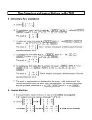
Program Description - Pellissippi State Community College
Program Description - Pellissippi State Community College
Program Description - Pellissippi State Community College

You also want an ePaper? Increase the reach of your titles
YUMPU automatically turns print PDFs into web optimized ePapers that Google loves.
GIS 1030 GIS Data Sources & Quality 3 Credits<br />
Provides a rigorous opportunity to become knowledgeable about sources and quality of a<br />
variety of commercial and public data available via the Internet. Much GIS data already exists<br />
but is difficult to find, often has quality problems and may only be available in certain file formats.<br />
The GIS professional must be able to evaluate data problems and be able to efficiently<br />
acquire the data and convert it to his/her use. Students examine a variety of GIS data, evaluate<br />
the meta-data and determine the quality as related to the expected end use. On Demand<br />
Prerequisite(s): GIS 1010<br />
GIS 1110 Intro to GIS Database Management 3 Credits<br />
Introduces the concept of database structure to GIS projects and provides skill training in<br />
the use of relational databases for spatial and multiple table queries. Structured Query<br />
Language (SQL) is used. Students design, develop, maintain, query and modify a variety of<br />
GIS databases. Database importing, exporting and file conversion are also covered. On<br />
Demand Prerequisite(s): GIS 1010<br />
GIS 1120 Desktop GIS Software Tools 3 Credits<br />
Instruction in the use of commercial GIS viewers and associated tools used in various courses<br />
and GIS projects. The specific product offered will vary depending on student needs and the<br />
commercial success of the software. The course will provide training on the use of products<br />
that are currently commercially viable. May be repeated for credit up to 9 hours with consent<br />
of GIS coordinator. On Demand Corequisite(s): GIS 1010 or consent of GIS coordinator<br />
GIS 1200 Global Positioning Technology 3 Credits<br />
Provides experience in planning and executing efficient data collection ranging from digitizing<br />
existing maps and images to collecting spatial feature attribute data with global positioning<br />
technology and creating GIS data layers. Students will become thoroughly familiar<br />
with GPS hardware and software and scanning and digitizing techniques to create and update<br />
GIS databases. On Demand Prerequisite(s): GIS 1010<br />
GIS 1600 Business Geographics 3 Credits<br />
Focuses on the business applications of GIS primarily concerned with the analysis of customer<br />
and demographic data in the context of the physical world. Business applications deal<br />
with the analysis of alternative retail locations, the evaluation of market opportunities and practical<br />
logistics. Demographic databases are queried and results visualized addressing specific<br />
business decisions. On Demand C o re q u i s i t e ( s ) :GIS 1010 or consent of GIS coordinator<br />
GIS 2030 Planning & Executing Projects 3 Credits<br />
Teaches the reality of contemporary GIS work that requires cost-effective planning and execution<br />
of projects that meet client needs and budgets. Student teams plan, bid, and execute<br />
small GIS projects and are evaluated on their efficiency and effectiveness in meeting client<br />
need, cost, teamwork and profitability criteria. Prepares students for independent work in GIS<br />
2050. On Demand Prerequisite(s): GIS 1010 and 1110<br />
GIS 2050 Independent GIS Projects 3 Credits<br />
This course is carried out independently by the student after consultation with the GIS advisor<br />
to specify the project deliverables. Results of the project work are reported as a seminar to<br />
simulate delivery of the final product to the client. On Demand Prerequisite(s): GIS 2030<br />
GIS 2120 Image & RasterGIS Analysis 3 Credits<br />
Provides training in the use of advanced image and raster GIS tools, including the analysis<br />
of multispectral satellite data now widely available. Students will also be trained to use<br />
3D tools to visualize GIS data. Data from the Endeavor satellite that made the first 3D map<br />
of the Earth will also be incorporated. Provides the analytical basis for the preparation of<br />
raster data for use in GIS 2510. On Demand P re re q u i s i t e ( s ) : GIS 1010 and 1020; or consent<br />
of GIS coordinator<br />
GIS 2410 GIS Web Applications 3 Credits<br />
Provides the opportunity for students to use the latest Internet mapping tools to deliver GIS<br />
and location-based services via the Internet. Students will be trained to deliver GIS applications<br />
on the Internet using a variety of tools and emerging raster and vector standards. On<br />
Demand Prerequisite(s): GIS 1010 or consent of GIS coordinator<br />
◆ Meets <strong>Pellissippi</strong> <strong>State</strong> and Tennessse Board of Regents minimum degree requirements. ★ Transfers as equivalent course to the University of Tennessee, Knoxville.<br />
213