HEADING PAGE - port of ploce authority * welcome
HEADING PAGE - port of ploce authority * welcome
HEADING PAGE - port of ploce authority * welcome

You also want an ePaper? Increase the reach of your titles
YUMPU automatically turns print PDFs into web optimized ePapers that Google loves.
ENVIRONMENTAL IMPACT STUDY<br />
Rn: 03-033 CONTAINER TERMINAL PLOCE <strong>PAGE</strong>: 26<br />
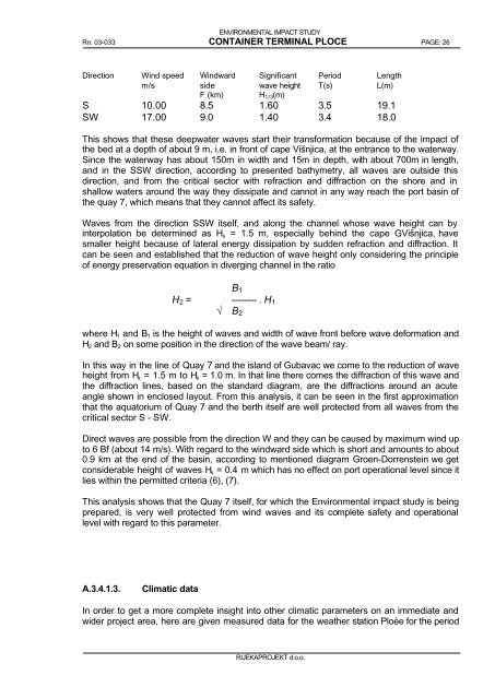
Direction Wind speed<br />
m/s<br />
Windward<br />
side<br />
F (km)<br />
Significant<br />
wave height<br />
H1/3(m)<br />
RIJEKAPROJEKT d.o.o.<br />
Period<br />
T(s)<br />
Length<br />
L(m)<br />
S 10.00 8.5 1.60 3.5 19.1<br />
SW 17.00 9.0 1.40 3.4 18.0<br />
This shows that these deepwater waves start their transformation because <strong>of</strong> the impact <strong>of</strong><br />
the bed at a depth <strong>of</strong> about 9 m, i.e. in front <strong>of</strong> cape Višnjica, at the entrance to the waterway.<br />
Since the waterway has about 150m in width and 15m in depth, with about 700m in length,<br />
and in the SSW direction, according to presented bathymetry, all waves are outside this<br />
direction, and from the critical sector with refraction and diffraction on the shore and in<br />
shallow waters around the way they dissipate and cannot in any way reach the <strong>port</strong> basin <strong>of</strong><br />
the quay 7, which means that they cannot affect its safety.<br />
Waves from the direction SSW itself, and along the channel whose wave height can by<br />
interpolation be determined as Hs = 1.5 m, especially behind the cape G.Višnjica, have<br />
smaller height because <strong>of</strong> lateral energy dissipation by sudden refraction and diffraction. It<br />
can be seen and established that the reduction <strong>of</strong> wave height only considering the principle<br />
<strong>of</strong> energy preservation equation in diverging channel in the ratio<br />
B1<br />
H2 = -------- . H1<br />
√ B2<br />
where H1 and B1 is the height <strong>of</strong> waves and width <strong>of</strong> wave front before wave deformation and<br />
H2 and B2 on some position in the direction <strong>of</strong> the wave beam/ ray.<br />
In this way in the line <strong>of</strong> Quay 7 and the island <strong>of</strong> Gubavac we come to the reduction <strong>of</strong> wave<br />
height from Hs = 1.5 m to Hs = 1.0 m. In that line there comes the diffraction <strong>of</strong> this wave and<br />
the diffraction lines, based on the standard diagram, are the diffractions around an acute<br />
angle shown in enclosed layout. From this analysis, it can be seen in the first approximation<br />
that the aquatorium <strong>of</strong> Quay 7 and the berth itself are well protected from all waves from the<br />
critical sector S - SW.<br />
Direct waves are possible from the direction W and they can be caused by maximum wind up<br />
to 6 Bf (about 14 m/s). With regard to the windward side which is short and amounts to about<br />
0.9 km at the end <strong>of</strong> the basin, according to mentioned diagram Groen-Dorrenstein we get<br />
considerable height <strong>of</strong> waves Hs = 0.4 m which has no effect on <strong>port</strong> operational level since it<br />
lies within the permitted criteria (6), (7).<br />
This analysis shows that the Quay 7 itself, for which the Environmental impact study is being<br />
prepared, is very well protected from wind waves and its complete safety and operational<br />
level with regard to this parameter.<br />
A.3.4.1.3. Climatic data<br />
In order to get a more complete insight into other climatic parameters on an immediate and<br />
wider project area, here are given measured data for the weather station Ploèe for the period