Ternate - Smithsonian Institution Libraries
Ternate - Smithsonian Institution Libraries
Ternate - Smithsonian Institution Libraries

You also want an ePaper? Increase the reach of your titles
YUMPU automatically turns print PDFs into web optimized ePapers that Google loves.
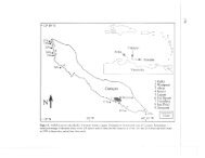
TERNATE 36 TOPOGRAPHY AND TRAVEL DESCRIPTIONS<br />
<strong>Ternate</strong> by a narrow strait. Then we steer along the most northern point of Tidore, and<br />
have not yet passed this point when the overgrown rock of Filonga appears, remaining in<br />
sight until we come very close to the coast of Halmahera. This rock forms the top of an<br />
underwater peak and is completely covered with bushes and brush wood. It is rarely<br />
exposed to storms or high seas since the channel is sheltered from all sides. 4<br />
Slowly we reach our destination, recognizable by an immense row of mangroves,<br />
between which the mouth of the river can be found only with difficulty. The Utusan<br />
(representative) who is stationed here meets us with the unwelcome news that the tide is<br />
still going out and that it will be a few hours before our proa can navigate the shallow river.<br />
Used to such setbacks when traveling in this region, we patiently wait for high tide, and<br />
regret only that there is nothing to enliven the monotonous environment. Finally a shout<br />
lets us know that a first attempt will be made. Propelled with long bamboo poles, the proa<br />
glides imperceptibly between intertwined roots up the river. Half an hour later we step out<br />
into the village of Dodinga and make our way to the rest house which stands just across<br />
from the ruins of the former fort. 5 [p. 55]<br />
There is not much to see: only twenty or so houses, some built on the ground, others<br />
on piles. In the center there is a mosque, a pasar (open market) shed, and the almost<br />
completely overgrown brickwork of a mostly dilapidated fortress, flanked by a small avenue<br />
with galala trees. 6 Yet Dodinga is actually rather important, since many of the goods being<br />
delivered to East Halmahera pass through it and, conversely, other goods are transported<br />
to the west coast via the pass, going on from there to <strong>Ternate</strong>. This route is much shorter<br />
and avoids the dangers to which the sea route is subject.<br />
The fort is as old as the old enmities between <strong>Ternate</strong> and Tidore. It was built to<br />
protect the pass and to prevent the servants of the Company from having to trade with<br />
whichever war party was temporarily most powerful. After the border between the two<br />
states had been shifted further south 7 and the pass came under the administration of<br />
government in <strong>Ternate</strong>, these complications disappeared. Nevertheless, a small garrison,<br />
consisting of six ratings and a corporal, remained stationed there for years afterwards; the<br />
corporal was required to check the travel documents of the persons traveling through and<br />
was authorized to make decisions in minor disputes between chiefs or between the people<br />
4 [p. 54, n. 1] Hiri is a mountain approximately two thousand feet high, located to the north of<br />
<strong>Ternate</strong> and opposite Takome. Only boar and deer live there; it is not inhabited. The spellings<br />
“Hira” and “Hierrie” are no more correct than that of “Filongia” for Filonga.<br />
5 [p. 54, n. 2] Wallace (1870-1871, II:19) unloaded his luggage on the “beach;” he meant on the<br />
bank of the river or creek.<br />
6 [p. 55, n. 1] Galala is the <strong>Ternate</strong>se name for the Erythrina Picta L., which is found all over this<br />
archipelago. E. Lithosperma Bl., which has been planted in some places, is called galala bangah to<br />
distinguish it from the E. Picta.<br />
7 [p. 55, n. 2] This took place during the English interregnum. According to the agreement of<br />
October 27, 1814, the border was fixed as a straight line from the northern bank of the river Kayasa<br />
on the west coast to Tofongo on the east coast. This arrangement has remained unchanged in later<br />
contracts with the Government of the Dutch Indies.<br />
SMITHSONIAN INSTITUTION LIBRARIES DIGITAL EDITION