Ternate - Smithsonian Institution Libraries
Ternate - Smithsonian Institution Libraries
Ternate - Smithsonian Institution Libraries

Create successful ePaper yourself
Turn your PDF publications into a flip-book with our unique Google optimized e-Paper software.
TERNATE 64 TOPOGRAPHY AND TRAVEL DESCRIPTIONS<br />
Guruah Ping 27 ; he is mistaken, however, and really means the Benincasa Cerifera Savi,<br />
which has big fruit resembling melons. These are grown everywhere near the houses.<br />
The statute labor requirement for the population is not too severe: they have to<br />
supply one person to carry out statute labor at <strong>Ternate</strong> and one kabo to the Utusan. These<br />
two men are replaced every year.<br />
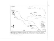
The Kayoa Islands are: Kayoa with Pulu Miskin and Guruah, and Waidoba,<br />
renamed Laluin by van Musschenbroek. [p. 97] This last name actually only refers to a<br />
part of the northeastern coast, however, and is derived from luin, or kora-kora, which<br />
means a place where vessels can be drawn up on dry land. 28 Near Waidoba there is Towada<br />
and a few more small islands; these form one island with Waidoba at low tide. The small<br />
islands are called Werimdi, Lagolian [as corrected in Errata —Trans.], Dobamelum, and<br />
Dok.<br />
Especially on Waidoba there are many paddy fields. They often have a poor yield<br />
because of late planting, and they have rarely been planted on woodland soil because of the<br />
heavy work entailed. The products are mainly bought by Tidorese for an average price of<br />
14 cents per kula of 3 cupa—that is, about 4.- per picul. The farmers store the paddy in<br />
their gardens and supply it once the sale has been agreed upon.<br />
The waterway between Kayoa and Waidoba is not navigable for bigger proas at low<br />
tide because of its many reefs and shallows; ships can anchor more to the east at a depth of<br />
twenty-five fathoms, but the reef around Guruah is too extensive to allow this.<br />
To the west of the Kayoa group lie a few smaller islands, called the Goaricis on the<br />
map. The name is a corruption of Gurah-Ici, which means small garden, the name of the<br />
most insignificant and trivial of all the islands. 29 As a matter of fact, they have no common<br />
name as a group and each one has its own separate name.<br />
These islands are under the Sangaji of Ngofakiaha who is charged in the name of<br />
the Sultan with the supervision of the following islands (those which are only separated at<br />
high tide are mentioned together):<br />
Gunangi and Laigoma; [p. 98]<br />
Siko, Tomako ma-Fatu [as corrected in Errata —Trans.], and Gafi;<br />
Lele, Gurah-Ici, and Kelo;<br />
27 [p. 96, n. 3] See Wallace, 1870-1871, II:38.<br />
28 [p. 97, n. 1] In his often-mentioned note on page 25 (in Bernstein, 1883), van Musschenbroek<br />
claims that laluin is a Casuarina—this is called lelei in <strong>Ternate</strong>se and Tidorese. He is indeed not<br />
afraid to make small mistakes: at the top of page 85, note 3, and on page 33, he identifies the<br />
description heard by Bernstein on East Halmahera of the lelei, without further ado, as<br />
Leptospermum Amboinense, a tree which according to Miquel’s Flora occurs on Ceram!<br />
29 [p. 97, n. 2] MacLeod even has an incorrect explanation for this incorrect spelling. It appears<br />
that Spanish is involved (Tijdschrift van het Aardrijkskundig Genootschap, V:25).<br />
SMITHSONIAN INSTITUTION LIBRARIES DIGITAL EDITION