Ternate - Smithsonian Institution Libraries
Ternate - Smithsonian Institution Libraries
Ternate - Smithsonian Institution Libraries

Create successful ePaper yourself
Turn your PDF publications into a flip-book with our unique Google optimized e-Paper software.
TERNATE 57 TOPOGRAPHY AND TRAVEL DESCRIPTIONS<br />
days of July 1849. The Resident, Visser, went there himself on the brig De Zwaluw. A few<br />
shots were fired at the high village, killing some of the headmen, and the culprits and the<br />
leader, Prince Siko, were soon captured. The area has remained quiet since then.<br />
The terrain of the island is very uneven and has a steep slope except on the east<br />
side, where the plain of Malo Tangteng is situated. In earlier days there were many<br />
kampongs, but their inhabitants gradually moved to other villages because of the many<br />
rampant diseases here. At present there are a few plantations of maize, grown between<br />
banana trees, but after the eruption the soil became much less fertile because of the stones<br />
which came to be strewn all around.<br />
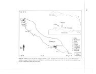
The main anchoring center is Pawate, which is on the east coast and is one-half<br />
hour’s row south of Ngofakiaha. There are few houses since most inhabitants stay at their<br />
plantations, but native proas are protected against winds, especially during the west<br />
monsoon. Moreover, there are many wells with good drinking water here. 4 Because [p. 86]<br />
there are no rivers and streams on the island, wells have been dug along the beach, their<br />
walls supported by evenly placed stones to prevent the earth crumbling. Great pains have<br />
been taken over some of these wells, and even close to the sea they supply pure sweet<br />
water—rarely is it brackish or muddy.<br />
The kampongs consist, as do the main villages, of a number of houses built almost<br />
on top of each other. The construction is very skillful. The people have also taken<br />
advantage of small even places on the stony slope of the mountain when building these<br />
houses. The floors are often partially supported so that they will be even. Most of the<br />
houses are square with an angular back because of later additions. They are very neatly<br />
finished with strong wooden posts between which the closely linked gabah slats form a<br />
strong wall. The largest number of houses is found at Ngofagita, where there are more<br />
than two hundred in an extremely small space. 5<br />
Ruins of old forts may be found at Ngofakiaha and Tafasolo; the former is still<br />
recognizable but very much overgrown with the roots of banyan trees; of the second one<br />
there is only some brickwork left. 6 Before the earthquake [p. 87] the village of Ngofakiaha<br />
4 [p. 85, n. 2] I do not understand why van Musschenbroek condemns “reaching the harbor of<br />
Pawate” [p. 86] (not Powati) as a too-euphemistic expression of Bernstein (in Bernstein 1883, p. 24,<br />
note). There is no question of “harbor” in the sense attached to it by us and Bernstein would have<br />
done better to call it an anchorage ground. It is certain, however, that he put in at Pawate and not<br />
at Ngofakiaha; during the west monsoon (Bernstein traveled during October) the roadstead of the<br />
latter place is not protected from the northwestern winds. Native proas, the means of conveyance of<br />
Bernstein, always go, as reported above, to Pawate.<br />
5 [p. 86, n. 1] In Bernstein’s account of his travels (1864, p. 81) he calls this village Mofenzita.<br />
This was most probably a clerical error that was not rectified by the editor since he did not know the<br />
correct name.<br />
6 [p. 86, n. 2] Valentijn speaks of a Fort Mauritius at Ngofakiaha and presumes that it was built<br />
by the Spanish or Portuguese (1724, Ib:90). Since he places it about three hundred steps from the<br />
beach, and mentions on page 1 a fortified landing dock near the beach, called Zeeburg, the present<br />
ruin situated near the sea is undoubtedly the latter and wrongly taken for the former, Mauritius, by<br />
van Musschenbroek, [p. 87] (loc. cit., note 13). The beautiful coffee trees observed by van<br />
SMITHSONIAN INSTITUTION LIBRARIES DIGITAL EDITION