Ternate - Smithsonian Institution Libraries
Ternate - Smithsonian Institution Libraries
Ternate - Smithsonian Institution Libraries

Create successful ePaper yourself
Turn your PDF publications into a flip-book with our unique Google optimized e-Paper software.
TERNATE 79 TOPOGRAPHY AND TRAVEL DESCRIPTIONS<br />
4. Capalulu, which is on the north and west coast, together with the islands of Pasiipa,<br />
Leko and Pasikena.<br />
Sulabesi has eight districts: Falahu, Kabau, Fagudu, Face, Gae, Bega, Ipa, and<br />
Pohea, and also three separate kampongs: Malbufa, Fakue, and Koloboti. 12<br />
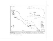
The islands of Taliabu and Mangole have their longest extent from west to east but<br />
the island of Sulabesi lies almost at a right angle to Mangole in a direction from north to<br />
south; from the southernmost point, called Cape Waka, the heights of Buru are clearly<br />
visible.<br />
On Sulabesi the main village is in a small bay on [p. 116] the northeast coast. This<br />
village is usually called Sanana, after the river which runs through it. The Salahakan or<br />
representative of the Sultan lives there. Generation after generation, however, this Sultan<br />
has been of Sulanese extraction.<br />
Sanana extends for more than fifteen hundred meters along the beach and includes<br />
the kampongs Waelau, 13 Umaga, Waemaka, Lantina, Pogelo, Pareya, Waetapil, Waena,<br />
and Moloia, totalling more than seven hundred souls in about fifty houses. The twelve<br />
Sangajis, or heads of the districts of Sulabesi and Mangole, live here together with those<br />
administering the kampongs of Malbufa, Koloboti, and Fakue. The Sangajis are appointed<br />
by the Sultan, the district heads by the Salahakan. The subordinates of the Salahakan are<br />
exempted from all services. They are put exclusively at the disposal of the Salahakan to<br />
work on his plantations or carry out domestic duties.<br />
The Salahakan, who receives an appointment certificate from the Resident, is<br />
assisted in his duties by <strong>Ternate</strong>se officials, namely a Jurtulis, a Kapita-Krois, a Captain-<br />
Kota, and a few soldiers. The Jurtulis is also head of the clergy. The Kapita-Krois is<br />
harbormaster and captain of the cruise-proa, with a crew consisting of twenty seamen<br />
12 [p. 115, n. 1] Valentijn (1724, Ib:87) speaks of “Xula Talyabu” and “Xula Mangoli,” which are<br />
not customary over there. He mentions on the first island the villages Talyabu, Likitobi, Woiyo,<br />
Singa, Kakibo, Lede, Samade, and Made, some of which are similar to the names given above. On<br />
Mangoli he only knows Waiytima and Mangoli and for Sulabesi he mentions ten villages, namely<br />
Falauw, “Cabauw,” Fattahoi, Talagga, Bega, Iga, Facquerre, Fagude, Fatze, and Gaiy, which names,<br />
although never investigated later on, are not completely correct either. Perhaps these names were<br />
given to him on <strong>Ternate</strong>, where even now they are not well-informed about the correct names of<br />
those islands. This is even more apparent from the list given by Bleeker (1856; most probably copied<br />
from the appendix of the contract, see De Indische Gids, IV[1]:693), in which the following islands<br />
are said to belong to the Sula Islands: Taliabu, Sehu, Bawana, Jeni, Limbu, Daluma, Aru, Sano,<br />
Mangkololi, Tunasim, Matete, Damain, Tabalami, Ketup, Makanateh, Nusa Hai, Nusa Mehuju,<br />
Aala, Sarumbah, Pasikaya, Tuntangan, Lahi, Penu, Sula Mangoli, Tubulu, Paskoro, Sulabesi, Lifa<br />
Matula, Pagama, and two unnamed islands. De Hollander (Handleiding..., 4th ed., p. 400, n. 1)<br />
copies this list word for word. I have tried in this sketched outline to give an idea of the boundaries<br />
between the districts and their probable size. This was done according to the directions of the native<br />
headmen.<br />
13 [p. 116, n. 1] Wae or wai is the well-known Polynesian word for water; the first spelling is the<br />
most likely pronunciation.<br />
SMITHSONIAN INSTITUTION LIBRARIES DIGITAL EDITION