In the urban areas of Caprivi, the affected people noted that risk reduction should involve the building of a water canal that will channel the flood water away from the vulnerable houses in the informal settlement sections of the city. In the rural Kavango Region, risk reduction should involve the moving of people to higher ground, though close to their old area, and build their new houses there. Resettlements are part of a longterm recovery plan, as many issues will have to be solved and planned, like land tenure, access to water and public services. The Government will need to consider whether to provide direct subsidies (cash), training, building materials, or let market instruments (such as insurance) be the main means of assistance to the affected people. In the case of distribution of construction materials (typically cement, rope, shovels, and wheel barrows), the distribution process would need to be done with regional authorities and communities to identify correctly the most affected households. Considering the high amount of the affected households in the six regions, it will be necessary to identify if this assistance should be given at the relocation camps, at the early resettlement level, or when people have already returned to their communities. Since housing is primarily a private damage, the Government will need to strike a careful balance between direct housing assistance to the affected people, and creating perverse incentives (moral hazard) for poor people to resettle back in high risk zones. Typically after disasters, there is a boost in demand for construction materials, which can lead to heavy demand for wood (placing further pressure on the environment). It is important to promote the use of sustainable solutions, such as soil-cement bricks, alternative energy sources, and, if wood must be used, reforestation. Relocation to Safer Areas In some cases where houses are located in a highly exposed floodplain, housing relocation to safer (higher) grounds may be the only solution. By far, the preferred solution is for the homeowner to move voluntarily to a higher location close by, as identified by the participatory flood risk mapping (see DRM section). In this case, it is crucial to use markers as references of past floods, to remind community members that such floods may come back, and that resettlement in high risk areas is to be discouraged at all costs. In areas subject to extensive flooding, there may be no choice but to resettle a larger number of households into safer grounds. International experience has shown, however, that resettlement following disaster carries numerous risks that are often underestimated by the Government and humanitarian agencies. from the communities’ original livelihoods or social networks; new settlements which no longer allow for kinships or social cohesion; failure to provide for farming needs (e.g. space for livestock, tool sheds); (iv) inadequate housing materials; (v) groups resettled together that belong to different ethnic or cultural groups, or social backgrounds; and conflict or competition with adjacent communities with valid claims over resettlement sites. Successful resettlement programmes post-disaster have tended to include the following features: (i) the affected communities have participated actively in the site selection, housing design and features of resettlement planning; (ii) past livelihoods (e.g. fishing) have not been disrupted; (iii) basic needs and aspirations—health, education, jobs, water, transport— continue to be accessible and affordable at the new sites; (iv) the resettled community belongs to similar ethnic, cultural background or has similar occupations (e.g. farming/fishing); (v) they lack excessive emotional ties to the old sites, and are able to bring with them items of high emotional, spiritual or cultural value; and the housing designs, layouts and natural habitats conform to the community’s way of life. Semi-permanent structures Semi-permanent structures in flooded areas can be of three kinds: (i) Relocation camps and their logistical support warehouses, (ii) Elevated or floating platforms, and (iii) Temporary housing. Relocation camps are basically structures that would be ready to receive refugees during disaster times, with semi-permanent water, sanitation, electricity, shelter and cooking facilities. They should have permanent fences, gates and security. During non-disaster times, the facilities could be used as community centres. They would be supported by logistical structures (warehouses) equipped to store or rapidly receive food and materials for disaster victims. Floating platforms (equipped with water and food) allow population in critical floodplain areas to assemble temporarily and facilitate collection and relief efforts. In some flood-prone areas of Mozambique, they even function as temporary schools. In some flood-prone zones where permanent relocation may not be a culturally-acceptable solution, the community may prefer to keep temporary houses in the floodplain, and permanent structure in the periphery (safer grounds). Common reasons for the failure of these programmes include: 34 resettled sites which are inappropriate, or distant 34 Jha, Abas, <strong>2009</strong>. Handbook for Post-Disaster Housing and Community Reconstruction. Draft. ISDR, <strong>GFDRR</strong>, World Bank. 93
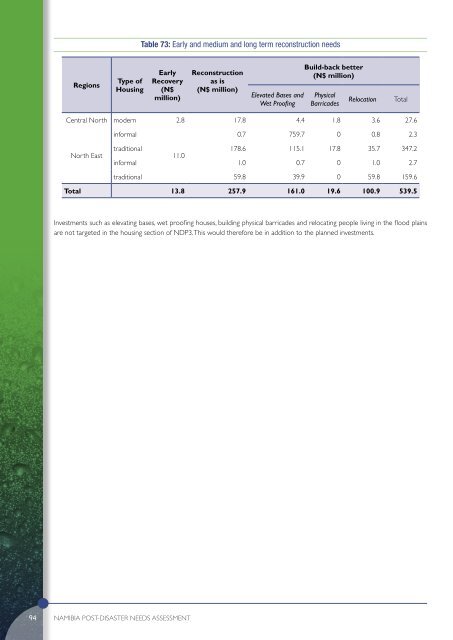
Table 73: Early and medium and long term reconstruction needs Regions Type of Housing Early Recovery (N$ million) Reconstruction as is (N$ million) Elevated Bases and Wet Proofing Build-back better (N$ million) Physical Barricades Relocation Total Central North modern 2.8 17.8 4.4 1.8 3.6 27.6 informal 0.7 759.7 0 0.8 2.3 North East traditional 178.6 115.1 17.8 35.7 347.2 11.0 informal 1.0 0.7 0 1.0 2.7 traditional 59.8 39.9 0 59.8 159.6 Total 13.8 257.9 161.0 19.6 100.9 539.5 Investments such as elevating bases, wet proofing houses, building physical barricades and relocating people living in the flood plains are not targeted in the housing section of NDP3. This would therefore be in addition to the planned investments. 94 <strong>Namibia</strong> POST-DISASTER NEEDS ASSESSMENT
- Page 1 and 2:
POST-DISASTER NEEDS ASSESSMENT FLOO
- Page 3 and 4:
Foreword In March of 2009, torrenti
- Page 5 and 6:
Table of Contents Foreword ii Ackno
- Page 7 and 8:
Table 51 Indication of losses incur
- Page 9 and 10:
List of Abbreviations AIDS Acquired
- Page 11 and 12:
Executive Summary In March 2009, fl
- Page 13 and 14:
The recommendations for recovery an
- Page 15 and 16:
Strengthened Community Awareness Co
- Page 17 and 18:
1.1 The 2009 Floods Omusati Oshana
- Page 19 and 20:
In addition, the President called u
- Page 21 and 22:
prolonged dry spells and droughts),
- Page 23 and 24:
2.1 Methodology In the aftermath of
- Page 25 and 26:
Figure 10: Distribution of damage (
- Page 27 and 28:
The average value of damage in the
- Page 29 and 30:
3.1 Sector Impacts: Infrastructure
- Page 31 and 32:
Rail and Air Transport There was no
- Page 33 and 34:
3.2 3.2.1 Sector Impacts: Productiv
- Page 35 and 36:
Needs/Timeline Table 16: Summary of
- Page 37 and 38:
worst, some in Oshikoto, Kavango an
- Page 39 and 40:
Private sector reconstruction using
- Page 41 and 42:
not have to provide food to learner
- Page 43 and 44:
Needs The needs of the environment
- Page 45 and 46:
4.1 Macro-economic Impact This sect
- Page 47 and 48:
Impact on the balance of payment Th
- Page 49 and 50:
4.2 Impact on Income and livelihood
- Page 51 and 52:
HIV/AIDS The floods caused consider
- Page 53 and 54:
5.1 Introduction The most likely sc
- Page 55 and 56:
Box: 2: Early Recovery: Guiding pri
- Page 57 and 58: Housing, shelter and settlements Th
- Page 59 and 60: 5.4 Recommendations on when to move
- Page 61 and 62: 6.1 Recovery and Reconstruction Str
- Page 63 and 64: Figure 36: Long-term reconstruction
- Page 65 and 66: 6.5 The way forward The medium and
- Page 67 and 68: 7.1 Situation during the Disaster T
- Page 69 and 70: of 2-6oC by end of the century, a l
- Page 71 and 72: could involve flags, megaphones or
- Page 73 and 74: 7.3 On-going interventions While th
- Page 75 and 76: Annex 1 Water Supply and Sanitation
- Page 77 and 78: access. It was observed that if the
- Page 79 and 80: water. Similarly, access roads from
- Page 81 and 82: Table 44: Roads proposed for improv
- Page 83 and 84: Annex 3 Energy Pre-disaster Situati
- Page 85 and 86: Table 50: Losses incurred due to 20
- Page 87 and 88: Annex 4 Agriculture, Livestock and
- Page 89 and 90: System (NEWFIS), reported concerns
- Page 91 and 92: and affect both urban and rural vul
- Page 93 and 94: In 1998, the Government launched a
- Page 95 and 96: Annex 5 Industry and Commerce Pre-d
- Page 97 and 98: In Namibia, small businesses can be
- Page 99 and 100: Needs In light of the vulnerability
- Page 101 and 102: Table 66: Total damages and lost re
- Page 103 and 104: Governance Issues Namibia is one of
- Page 105 and 106: constructed elevated roads increase
- Page 107: epresents 31 percent. In comparison
- Page 111 and 112: and reproductive health. This was f
- Page 113 and 114: Provision of safe water was done by
- Page 115 and 116: Intensive capacity-building activit
- Page 117 and 118: The Table below indicates the numbe
- Page 119 and 120: Table 80: Budget for 2008/2009 and
- Page 121 and 122: The total damages and losses are su
- Page 123 and 124: displacement and often impact girls
- Page 125 and 126: Needs The education sector response
- Page 127 and 128: The major long-term environmental c
- Page 129 and 130: paltry in comparison to ongoing thr
- Page 131 and 132: Table 90: Environment sector needs
- Page 133 and 134: Annex 11 Food Security Pre-disaster
- Page 135 and 136: mahangu and maize meal must be mutu
- Page 137 and 138: Figure 42: Maize Meal Prices in Urb
- Page 139 and 140: The total amount of food commoditie
- Page 141 and 142: Food distributions • To strengthe
- Page 143 and 144: Annex 12 GIS Mapping Background One
- Page 145 and 146: spectrum (and roughly comparable to
- Page 147 and 148: Useful web links and References For
- Page 149 and 150: Activities Key Outputs Time Frame R
- Page 151: Activities Key Outputs Time Frame R