

Namibia PDNA 2009 - GFDRR
Namibia PDNA 2009 - GFDRR
Namibia PDNA 2009 - GFDRR

You also want an ePaper? Increase the reach of your titles
YUMPU automatically turns print PDFs into web optimized ePapers that Google loves.
The major long-term environmental challenges for <strong>Namibia</strong> will<br />
be posed by rapid population growth and climate change. Due<br />
to the relatively light development pressures to date, much<br />
remains to be done to strengthen systems for environmental<br />
impact assessment and mitigation, currently well-established<br />
only for large mining operations. There have been active<br />
successes for environmental management, however, such as<br />
the rapid development of the national CBNRM approach, and<br />
increases in numbers of large wildlife throughout much of the<br />
country.<br />
Damage and Losses Assessment<br />
The <strong>2009</strong> flooding mostly affected three geographically distinct<br />
regions across northern <strong>Namibia</strong>. From east to west:<br />
Caprivi and Kavango. This is the most densely forested region of<br />
<strong>Namibia</strong>, but the forests are still relatively dry and open with<br />
grasses and shrub occupying much of the area. The forests are<br />
based on remnants of ancient Kalahari linear dunes that form<br />
a remarkable system of parallel shallow vales only around 2km<br />
in width, but stretching over hundreds of kilometres in length.<br />
The areas actually flooded were confined to the floodplains of<br />
the major rivers. In eastern and southern Caprivi, the Zambezi<br />
and Chobe Rivers have broad floodplains largely covered by<br />
grasses, with only sporadic clumps of trees on slightly higher<br />
mounds that are often also shared with small settlements. The<br />
Okavango and Kwandu have narrower floodplains covered<br />
with mostly with grasses, but also with denser gallery forest<br />
in some areas.<br />
Although the overall population of Caprivi and Kavango is<br />
not high, it is concentrated along the edge of the floodplains,<br />
and increasing within them. Very little of the area (around 4<br />
percent) is converted to permanent agriculture, but that does<br />
not mean that habitats have not been modified over time by<br />
burning, grazing and probably itinerant agriculture. There are<br />
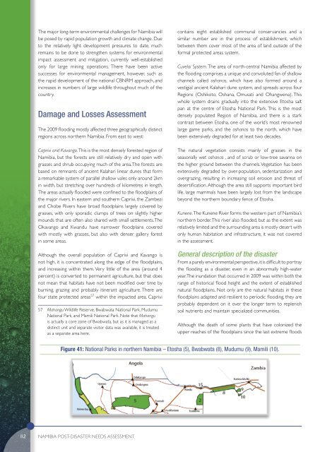
four state protected areas 57 within the impacted area. Caprivi<br />
57 Mahangu Wildlife Reserve, Bwabwata National Park, Mudumu<br />
National Park, and Mamili National Park. Note that Mahangu<br />
is actually a core zone of Bwabwata, but as it is managed as a<br />
distinct unit and separate visitor data was available, it is treated<br />
as a separate area here.<br />
contains eight established communal conservancies and a<br />
similar number are in the process of establishment, which<br />
between them cover most of the area of land outside of the<br />
formal protected areas system.<br />
Cuvelai System. The area of north-central <strong>Namibia</strong> affected by<br />
the flooding comprises a unique and convoluted fan of shallow<br />
channels called oshanas, which have also formed around a<br />
vestigial ancient Kalahari dune system, and spreads across four<br />
Regions (Oshikoto, Oshana, Omusati and Ohangwena). This<br />
whole system drains gradually into the extensive Etosha salt<br />
pan at the centre of Etosha National Park. This is the most<br />
densely populated Region of <strong>Namibia</strong>, and there is a stark<br />
contrast between Etosha, one of the world’s most renowned<br />
large game parks, and the oshanas to the north, which have<br />
been extensively degraded for at least two decades.<br />
The natural vegetation consists mainly of grasses in the<br />
seasonally wet oshanas , and of scrub or low-tree savanna on<br />
the higher ground between the channels. Vegetation has been<br />
extensively degraded by over-population, sedentarization and<br />
overgrazing, resulting in increasing soil erosion and threat of<br />
desertification. Although the area still supports important bird<br />
life, large mammals have been largely lost from the landscape<br />
beyond the northern boundary fence of Etosha.<br />
Kunene. The Kunene River forms the western part of <strong>Namibia</strong>’s<br />
northern border. This river also flooded, but as the extent was<br />
relatively limited and the surrounding area is mostly desert with<br />
only human habitation and infrastructure, it was not covered<br />
in the assessment.<br />
General description of the disaster<br />
From a purely environmental perspective, it is difficult to portray<br />
the flooding as a disaster, even in an abnormally high-water<br />
year. The inundation that occurred in <strong>2009</strong> was within both the<br />
range of historical flood height and the extent of established<br />
natural floodplains. Not only are the natural habitats in these<br />
floodplains adapted and resilient to periodic flooding, they are<br />
probably dependent on it over the longer term to replenish<br />
soil nutrients and maintain specialized communities.<br />
Although the death of some plants that have colonized the<br />
upper reaches of the floodplains since the last extreme floods<br />
Figure 41: National Parks in northern <strong>Namibia</strong> – Etosha (5), Bwabwata (8), Mudumu (9), Mamili (10).<br />
112<br />
<strong>Namibia</strong> POST-DISASTER NEEDS ASSESSMENT


