

Namibia PDNA 2009 - GFDRR
Namibia PDNA 2009 - GFDRR
Namibia PDNA 2009 - GFDRR

You also want an ePaper? Increase the reach of your titles
YUMPU automatically turns print PDFs into web optimized ePapers that Google loves.
1.1<br />
The <strong>2009</strong> Floods<br />
Omusati<br />
Oshana<br />
Ohangwena<br />
Oshikoto<br />
Kavango<br />
Caprivi<br />
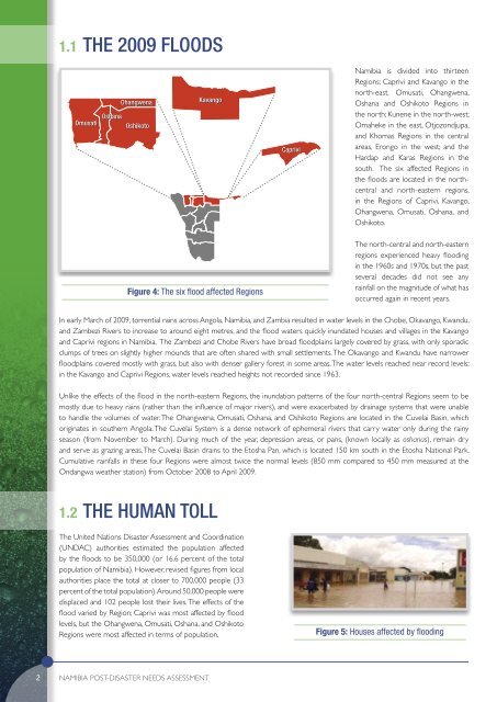
<strong>Namibia</strong> is divided into thirteen<br />
Regions: Caprivi and Kavango in the<br />
north-east, Omusati, Ohangwena,<br />
Oshana and Oshikoto Regions in<br />
the north; Kunene in the north-west;<br />
Omaheke in the east, Otjozondjupa,<br />
and Khomas Regions in the central<br />
areas, Erongo in the west; and the<br />
Hardap and Karas Regions in the<br />
south. The six affected Regions in<br />
the floods are located in the northcentral<br />
and north-eastern regions,<br />
in the Regions of Caprivi, Kavango,<br />
Ohangwena, Omusati, Oshana, and<br />
Oshikoto.<br />
Figure 4: The six flood affected Regions<br />
The north-central and north-eastern<br />
regions experienced heavy flooding<br />
in the 1960s and 1970s, but the past<br />
several decades did not see any<br />
rainfall on the magnitude of what has<br />
occurred again in recent years.<br />
In early March of <strong>2009</strong>, torrential rains across Angola, <strong>Namibia</strong>, and Zambia resulted in water levels in the Chobe, Okavango, Kwandu,<br />
and Zambezi Rivers to increase to around eight metres, and the flood waters quickly inundated houses and villages in the Kavango<br />
and Caprivi regions in <strong>Namibia</strong>. The Zambezi and Chobe Rivers have broad floodplains largely covered by grass, with only sporadic<br />
clumps of trees on slightly higher mounds that are often shared with small settlements. The Okavango and Kwandu have narrower<br />
floodplains covered mostly with grass, but also with denser gallery forest in some areas. The water levels reached near record levels:<br />
in the Kavango and Caprivi Regions, water levels reached heights not recorded since 1963.<br />
Unlike the effects of the flood in the north-eastern Regions, the inundation patterns of the four north-central Regions seem to be<br />
mostly due to heavy rains (rather than the influence of major rivers), and were exacerbated by drainage systems that were unable<br />
to handle the volumes of water. The Ohangwena, Omusati, Oshana, and Oshikoto Regions are located in the Cuvelai Basin, which<br />
originates in southern Angola. The Cuvelai System is a dense network of ephemeral rivers that carry water only during the rainy<br />
season (from November to March). During much of the year, depression areas, or pans, (known locally as oshanas), remain dry<br />
and serve as grazing areas. The Cuvelai Basin drains to the Etosha Pan, which is located 150 km south in the Etosha National Park.<br />
Cumulative rainfalls in these four Regions were almost twice the normal levels (850 mm compared to 450 mm measured at the<br />
Ondangwa weather station) from October 2008 to April <strong>2009</strong>.<br />
1.2<br />
The Human Toll<br />
The United Nations Disaster Assessment and Coordination<br />
(UNDAC) authorities estimated the population affected<br />
by the floods to be 350,000 (or 16.6 percent of the total<br />
population of <strong>Namibia</strong>). However, revised figures from local<br />
authorities place the total at closer to 700,000 people (33<br />
percent of the total population). Around 50,000 people were<br />
displaced and 102 people lost their lives. The effects of the<br />
flood varied by Region; Caprivi was most affected by flood<br />
levels, but the Ohangwena, Omusati, Oshana, and Oshikoto<br />
Regions were most affected in terms of population.<br />
Figure 5: Houses affected by flooding<br />
2<br />
<strong>Namibia</strong> POST-DISASTER NEEDS ASSESSMENT


