

Namibia PDNA 2009 - GFDRR
Namibia PDNA 2009 - GFDRR
Namibia PDNA 2009 - GFDRR

You also want an ePaper? Increase the reach of your titles
YUMPU automatically turns print PDFs into web optimized ePapers that Google loves.
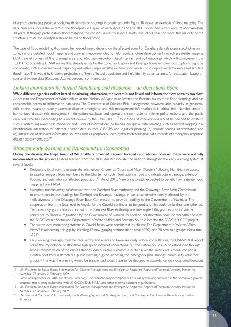
of any structures (e.g. public schools, health centres, or housing) into safer grounds. Figure 38 shows an example of flood mapping. The<br />
dark blue area shows the extent of the floodplain in Caprivi in early April <strong>2009</strong>. The <strong>2009</strong> floods had a frequency of approximately<br />
40 years. If, through participatory flood mapping, the consensus was to select a safety level of 50 years or more, the majority of the<br />
structures inside the floodplain should be made flood proof.<br />
The type of flood modelling that would be needed would depend on the affected zone. For Cuvelai, a densely populated, high-growth<br />
zone, a more detailed flood mapping and zoning is recommended to help regulate future development (including satellite mapping,<br />
LIDAR aerial surveys of the drainage area, and adequate resolution digital terrain and soil mapping), which will complement the<br />
1,000 km2 of existing LIDAR survey that already exists for the zone. For Caprivi and Kavango, however, lower cost options might be<br />
considered, such as coarser flood maps coupled with a simple satellite rainfall-runoff models to compute water balances and simulate<br />
flood maps. This would help derive projections of likely affected population and help identify potential areas for evacuation based on<br />
coarse elevation data (Kwabena Asante, personal communication).<br />
Linking Information for Hazard Monitoring and Response – an Operations Room<br />
While different agencies collect hazard monitoring information, the system is not linked and information flow remains too slow.<br />
At present, the Department of Water Affairs at the Ministry of Agriculture, Water and Forestry issues most flood warnings and has<br />
considerable access to information databases. The Directorate of Disaster Risk Management, however, lacks capacity in geospatial<br />
skills or the means to rapidly assemble disaster emergency and risk management information. It is critical that <strong>Namibia</strong> create a<br />
harmonized disaster risk management information database and operations room able to inform policy makers and the public<br />
on a real-time basis. According to a recent review by the UN-SPIDER, 17 four types of interventions would be needed to establish<br />
such a system: (a) awareness raising for end users of information; (b) training on spatial data handling, such as hazard mapping, risk<br />
identification, integration of different disaster data sources, GIS/GPS, and logistical planning; (c) remote sensing interpretation; and<br />
(d) integration of delinked information sources such as geophysical data, hydro-meteorological data, records of emergency response,<br />
disaster assessments, etc. 18<br />
Stronger Early Warning and Transboundary Cooperation<br />
During the disaster, the Department of Water Affairs provided frequent forecasts and advices; however, these were not fully<br />
implemented on the ground. Lessons learned from the <strong>2009</strong> disaster indicate the need to strengthen the early warning system at<br />
several levels:<br />
• Designate a focal point to activate the International Charter on “Space and Major Disasters” allowing <strong>Namibia</strong> free access<br />
to satellite imagery from members to the Charter for such information as road and infrastructure damage, extent of<br />
flooding and estimation of affected population. 19 As of 2010, <strong>Namibia</strong> is already expected to benefit from satellite flood<br />
mapping from NASA.<br />
• Strengthen transboundary collaboration with the Zambezi River Authority and the Okavango River Basin Commission<br />
to ensure continuous readings for Zambezi and Kavango. Kavango, in particular, remains deeply affected by the<br />
ineffectiveness of the Okavango River Basin Commission to provide readings to the Government of <strong>Namibia</strong>. The<br />
cooperation from the local level in Angola for the Cuvelai continues to be good, and this could be further strengthened.<br />
The previously good collaboration with the Zambezi River Authority was interrupted this year because of stricter<br />
adherence to financial regulations by the Government of <strong>Namibia</strong>. In addition, collaboration could be strengthened with<br />
the SADC Water Sector and Department of Water Affairs and Forestry, South Africa for the SADC-HYCOS project.<br />
• The water level monitoring stations in Cuvelai Basin were considered insufficient. The Department of Water Affairs,<br />
MAWF is addressing this gap by installing 17 new gauging stations (for a total of 20), and 20 new rain gauges (for a total<br />
of 21).<br />
• Early warning messages must be received by end users and taken seriously. In local consultations, the UN-SPIDER report<br />
noted the importance of affordable high speed internet connections, but the system could also be established through<br />
simple interpretation of the rainfall stations. When rainfall surpasses a certain level, the river level is measured and if<br />
a critical foot level is detected, a public warning is given, activating the emergency plan amongst community volunteer<br />
groups. 20 The way the warning would be transmitted would have to be designed in accordance with local conditions, but<br />
17 UN Platform for Space Based Information for Disaster Management and Emergency Response “Report of Technical Advisory Mission to<br />
<strong>Namibia</strong>” 27 January-2 February <strong>2009</strong>.<br />
18 Some arrangements for 2010 are already underway. For example, major components of a full system are contained in the sensorweb project<br />
proposal that is being elaborated with UNOOSA, DLR, NASA and other external support organizations.<br />
19 UN Platform for Space Based Information for Disaster Management and Emergency Response “Report of Technical Advisory Mission to<br />
<strong>Namibia</strong>” 27 January-2 February <strong>2009</strong>.<br />
20 De Leon and Marroquin “A Community Early Warning Systems: A Strategy for the Local Management of Disaster Reduction in Central<br />
America”<br />
55


