

Namibia PDNA 2009 - GFDRR
Namibia PDNA 2009 - GFDRR
Namibia PDNA 2009 - GFDRR

You also want an ePaper? Increase the reach of your titles
YUMPU automatically turns print PDFs into web optimized ePapers that Google loves.
Relevant satellite data may be procured directly from commercial<br />
data vendors or provided under the so-called International<br />
Charter “Space and Major Disasters”, a voluntary arrangement<br />
amongst international space agencies to make their data assets<br />
available in case of disasters. The latter was triggered by the<br />
Government for the flooding events in northern <strong>Namibia</strong> (both<br />
in 2008 and <strong>2009</strong>). Given the nature of the event, and prevailing<br />
weather conditions, a number of SAR data sets were procured<br />
(from the Canadian Radarsat and German TerraSAR-X sensors,<br />
respectively). These were processed into flood extent maps by<br />
service entities like UNOSAT and the mapping department of the<br />
German Aerospace Center (ZKI-DLR). High resolution SPOT-5<br />
VNIR imagery was also used to generate flood extent samples<br />
around the major municipal areas. Publicly accessible copies with<br />
relevant metadata were made available to the <strong>PDNA</strong> team. A<br />
special request was made to ZKI-DLR for digital vector outlines<br />
of detected flood extent, for comparison to relevant GIS data<br />
sets that could be compiled in <strong>Namibia</strong>. JRC purchased further<br />
satellite data for field mission preparation and flood extent<br />
estimation (in particular a QuickBird very high resolution image<br />
of early April <strong>2009</strong> around Oshakati and a Formosat coverage of<br />
the Caprivi area). Flood maps and geo-referenced imagery were<br />
prepared as KML SuperOverlays to integrate easily into Google<br />
Earth.<br />
Figure 45: The UNOSAT flood extent map of a part of the Osumati region, derived from an ENVISAT ASAR image of 19<br />
March <strong>2009</strong>, provided under the International Charter “Space and Major Disasters” by the European Space Agency.<br />
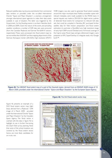
Figure 46: The DLR flood extent vector map<br />
Figure 46 presents an example of a<br />
DLR flood extent vector map (light<br />
blue), derived from a Radarsat-1 SAR<br />
image of 6 March <strong>2009</strong>, provided<br />
under the International Charter “Space<br />
and Major Disasters” by the Canadian<br />
Space Agency. The flood vector is<br />
overlaid with the data in figure 46 to<br />
highlight its use in further fine-tuning<br />
the DaLA field survey planning. Note<br />
that some of the school locations are<br />
covered by the flood extent vector,<br />
hence, are most likely candidates for<br />
an in-situ visit.<br />
131


