

Namibia PDNA 2009 - GFDRR
Namibia PDNA 2009 - GFDRR
Namibia PDNA 2009 - GFDRR

Create successful ePaper yourself
Turn your PDF publications into a flip-book with our unique Google optimized e-Paper software.
this coverage is not yet processed into new digital maps, are<br />
individual ortho-photo tiles of 10 by 10 km2 available at the<br />
DMS in digital format (GeoTIFF). Since the ortho-photos were<br />
collected in the dry season, they would have provided the best<br />
possible reference data set for the flood assessment work.<br />
1:250K maps are useful for general orientation and site<br />
location and 1:50K maps and digital ortho-photos in particular<br />
for detailed field verification mission planning and comparison<br />
to satellite image based results. For the field teams, some<br />
40 copies of paper maps at 1:250K and 1:50K scales were<br />
purchased. Unfortunately, DMS was not able to provide the<br />
<strong>PDNA</strong> team with digital map data at 1:50K and ortho-photo<br />
tiles for the affected towns.<br />
The Statistical Office of the National Planning Commission is<br />
collecting updated GIS data sets in preparation of the 2011<br />
census. Staff at the Census Bureau provided a number of specific<br />
sets that would support the DaLA sector specific analysis.<br />
Shapes files were provided for the following layers: agriculture,<br />
administrative boundaries (constituencies, regions), education,<br />
health, hydrology, planning, population, tourism, transportation<br />
and utilities. Some were specific to the northern regions, but<br />
several are for <strong>Namibia</strong> as a whole. Several of the layers are<br />
more actual than the equivalent DMS digital data sets. This is<br />
particularly relevant in the North, where significant changes<br />
were registered compared to the 1996 ortho-photo source.<br />
An update of the road network was collected in 2008 and<br />
<strong>2009</strong>, using GPS surveys.<br />
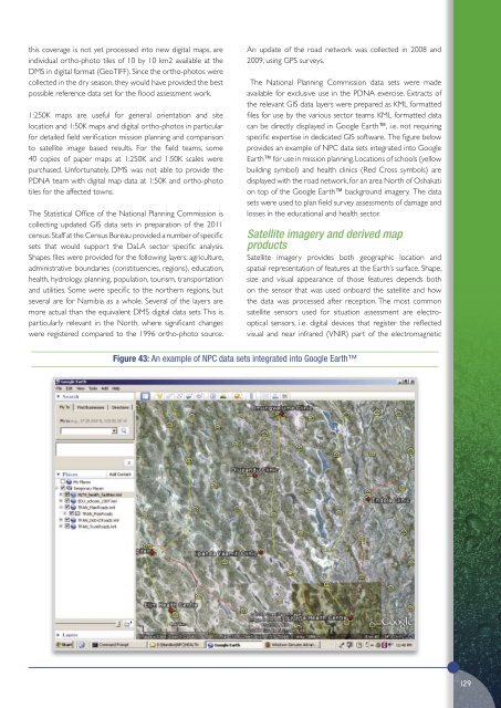
The National Planning Commission data sets were made<br />
available for exclusive use in the <strong>PDNA</strong> exercise. Extracts of<br />
the relevant GIS data layers were prepared as KML formatted<br />
files for use by the various sector teams. KML formatted data<br />
can be directly displayed in Google Earth, i.e. not requiring<br />
specific expertise in dedicated GIS software. The figure below<br />
provides an example of NPC data sets integrated into Google<br />
Earth for use in mission planning. Locations of schools (yellow<br />
building symbol) and health clinics (Red Cross symbols) are<br />
displayed with the road network, for an area North of Oshakati<br />
on top of the Google Earth background imagery. The data<br />
sets were used to plan field survey assessments of damage and<br />
losses in the educational and health sector.<br />
Satellite imagery and derived map<br />
products<br />
Satellite imagery provides both geographic location and<br />
spatial representation of features at the Earth’s surface. Shape,<br />
size and visual appearance of those features depends both<br />
on the sensor that was used onboard the satellite and how<br />
the data was processed after reception. The most common<br />
satellite sensors used for situation assessment are electrooptical<br />
sensors, i.e. digital devices that register the reflected<br />
visual and near infrared (VNIR) part of the electromagnetic<br />
Figure 43: An example of NPC data sets integrated into Google Earth<br />
129


