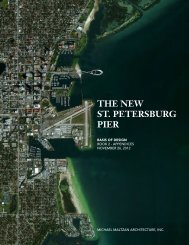
Book 1 - City of St. Petersburg
Book 1 - City of St. Petersburg
Book 1 - City of St. Petersburg

Create successful ePaper yourself
Turn your PDF publications into a flip-book with our unique Google optimized e-Paper software.
8. For coastal bridges, the vertical clearance <strong>of</strong> the<br />
superstructure shall be a minimum <strong>of</strong> 1 ft. above the 100-<br />
year design wave crest elevation including the storm surge<br />
elevation and wind setup. For bridge designs where this<br />
criterion cannot practically be met, refer to the FDOT<br />
Drainage Manual, Section 4.9.5.<br />
Horizontal Waterway Clearances<br />
Horizontal clearance is defined as the unobstructed clear<br />
distance between piers, fender systems, culvert walls, etc.<br />
projected by the bridge normal to the flow. The following<br />
minimum horizontal clearances shall be provided:<br />
1. For crossings subject to boat traffic, a minimum horizontal<br />
clearance <strong>of</strong> 10 ft. shall be provided.<br />
2. Where no boat traffic is anticipated, horizontal clearance<br />
shall be provided consistent with debris conveyance needs<br />
and structure economy.<br />
Regulatory Agency Requirements<br />
Vertical and horizontal clearances will also be subject to the<br />
requirements <strong>of</strong> the Coast Guard, Corps <strong>of</strong> Engineers, Water<br />
Management District and any other regulatory agency having<br />
appropriate statutory jurisdiction or authority. Such regulatory<br />
agency requirements may exceed Department requirements.<br />
Geotechnical Investigation<br />
A geotechnical investigation is necessary for the design <strong>of</strong> the<br />
new Pier. The geotechnical report should describe properties<br />
<strong>of</strong> the soils in the vicinity <strong>of</strong> the proposed Pier along with its<br />
Uplands connection and include all <strong>of</strong> the data collected, along<br />
with engineering analysis and recommendations. In general, the<br />
report should cover site terrain and geology including presence<br />
or depth <strong>of</strong> water, a boring plan and logs <strong>of</strong> exploratory borings,<br />
soil classifications and properties, recommendations for the<br />
foundation design including vertical and lateral load supporting<br />
capacities and design recommendations and values for piles.<br />
Information required from the geotechnical report includes:<br />
1. Description <strong>of</strong> site terrain and geology, including presence<br />
or depth <strong>of</strong> water.<br />
2. Description <strong>of</strong> exploration and sampling methods.<br />
3. A plan indicating the location <strong>of</strong> borings and the elevations<br />
related to the nearest benchmark. Borings and test pits shall<br />
be numbered and located dimensionally in plan.<br />
4. An evaluation <strong>of</strong> the subsurface stratigraphy and indication<br />
<strong>of</strong> the results in a cross section pr<strong>of</strong>ile.<br />
5. Logs <strong>of</strong> exploratory borings, including:<br />
• Surface elevation<br />
• Elevation, thickness, description and classification <strong>of</strong><br />
each soil stratum<br />
MICHAEL MALTZAN ARCHITECTURE, INC. 3 - 93