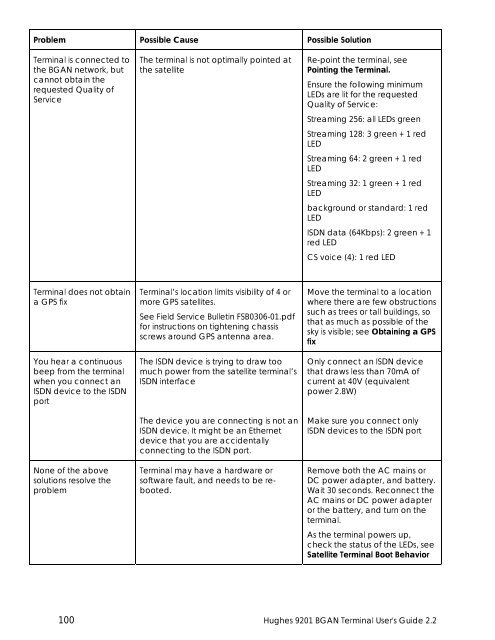
Problem Possible Cause Possible Solution<strong>Terminal</strong> is connected tothe <strong>BGAN</strong> network, butcannot obtain therequested Quality ofServiceThe terminal is not optimally pointed atthe satelliteRe-point the terminal, seePointing the <strong>Terminal</strong>.Ensure the following minimumLEDs are lit for the requestedQuality of Service:Streaming 256: all LEDs greenStreaming 128: 3 green + 1 redLEDStreaming 64: 2 green + 1 redLEDStreaming 32: 1 green + 1 redLEDbackground or standard: 1 redLEDISDN data (64Kbps): 2 green + 1red LEDCS voice (4): 1 red LED<strong>Terminal</strong> does not obtaina GPS fixYou hear a continuousbeep from the terminalwhen you connect anISDN device to the ISDNportNone of the abovesolutions resolve theproblem<strong>Terminal</strong>’s location limits visibility of 4 ormore GPS satellites.See Field Service Bulletin FSB0306-01.pdffor instructions on tightening chassisscrews around GPS antenna area.The ISDN device is trying to draw toomuch power from the satellite terminal’sISDN interfaceThe device you are connecting is not anISDN device. It might be an Ethernetdevice that you are accidentallyconnecting to the ISDN port.<strong>Terminal</strong> may have a hardware orsoftware fault, and needs to be rebooted.Move the terminal to a locationwhere there are few obstructionssuch as trees or tall buildings, sothat as much as possible of thesky is visible; see Obtaining a GPSfixOnly connect an ISDN devicethat draws less than 70mA ofcurrent at 40V (equivalentpower 2.8W)Make sure you connect onlyISDN devices to the ISDN portRemove both the AC mains orDC power adapter, and battery.Wait 30 seconds. Reconnect theAC mains or DC power adapteror the battery, and turn on theterminal.As the terminal powers up,check the status of the LEDs, seeSatellite <strong>Terminal</strong> Boot Behavior100 <strong>Hughes</strong> <strong>9201</strong> <strong>BGAN</strong> <strong>Terminal</strong> <strong>User's</strong> <strong>Guide</strong> <strong>2.2</strong>
TECHNOLOGY OVERVIEWGPSThe Global Positioning System (GPS) uses 24 orbital satellites to determine the position of the<strong>Terminal</strong> anywhere on the globe.OBTAINING A GPS FIXIn normal operation, a GPS receiver, such as that built in to the <strong>Terminal</strong>, needs to be able toreceive signals from at least four satellites so that it can then calculate a latitude, a longitudeand an altitude – this position fix is referred to as a 3-dimensional or 3-D fix. If only three GPSsatellites can be seen by the GPS receiver, then the last available altitude measurement isassumed and the GPS receiver calculates a position fix based on latitude and longitude only.This simpler position fix is referred to as a 2-dimensional or 2-D fix and is quicker and easier toobtain than a 3-D fix, but may be less accurate.The GPS receiver may take between a few seconds and 20 minutes to obtain a GPS fix,depending on how frequently the GPS receiver is being used. The frequency of use determinesthe how quickly the GPS <strong>Terminal</strong> is able to start.• Hot start − if the GPS receiver is being used frequently, (that is, in the last two hours), it isregularly updated with data from the GPS satellites, and so only takes a few seconds toobtain a GPS fix after being switched on.• Warm start − if a GPS receiver has not been used for more than two hours, then it will take upto 45 seconds to obtain a GPS fix.• Cold start − if the GPS receiver has not been used for some time or is 300 km or more fromwhere it was last used, it can take as long as 15 minutes to obtain a valid position fix.The time taken to obtain a valid GPS fix can also be affected by the visibility that the GPSreceiver has of the GPS satellites. The GPS system is relatively tolerant of atmospheric conditionssuch as heavy cloud or rainfall. However, physical blockages, such as tall buildings or terrain cansignificantly degrade the ability of the GPS receiver to obtain a fix. For this reason, ensure thatthe GPS receiver has a clear view of as much open sky as possible.GPS AND <strong>BGAN</strong> REGISTRATION<strong>BGAN</strong> uses the accurate position and timing information obtained from GPS to help ensureefficient registration of a <strong>BGAN</strong> <strong>Terminal</strong> with the <strong>BGAN</strong> network.Following successful registration and providing the <strong>Terminal</strong> is left switched on and remainsstationary, the GPS is no longer needed. Periodically, the <strong>BGAN</strong> <strong>Terminal</strong> contacts the <strong>BGAN</strong>network to inform the network that it is still switched on. In addition, the <strong>BGAN</strong> networkperiodically checks each <strong>Terminal</strong> for activity, and if the <strong>Terminal</strong> has not automaticallycontacted the <strong>BGAN</strong> network as described above, then the <strong>Terminal</strong> will be de-registered fromthe network.<strong>Hughes</strong> <strong>9201</strong> <strong>BGAN</strong> <strong>Terminal</strong> <strong>User's</strong> <strong>Guide</strong> <strong>2.2</strong> 101