- Page 1 and 2:
pp-i'"**•••%.
- Page 7:
LIBRARYOF THEr ry of Illinois.
- Page 10 and 11:
CITYUOAD.
- Page 12:
ivCONTEXTS.PAOBChap. II. Finland 20
- Page 18 and 19:
LIST OF ILLUSTRATIONS.ILLUSTRATIONS
- Page 20 and 21:
MonasteryLIST OF ILLUSTRATION'S.PAG
- Page 22 and 23:
2 THE NORTH-EAST ATLANTIC.islands,
- Page 24 and 25:
4 TIIE NOKTH-EAST ATLANTIC.The velo
- Page 26 and 27:
6THE NOETH-EAST ATLANTIC.boat manne
- Page 28 and 29:
8 THE NORTH-EAST ATLANTIC.the norma
- Page 30 and 31:
110 THE NORTH-EAST ATLANTIC.pole to
- Page 32 and 33:
12 THE NORTH-EAST ATLANTIC.Mohn has
- Page 34 and 35:
14 THE NORTH-EAST ATLANTIC.opposing
- Page 36 and 37:
1GTHE NOETH-EAST ATLANTIC.constant
- Page 38 and 39:
18 THE NOETH-EAST ATLANTIC.THE BALT
- Page 40 and 41:
•.'It1,10,I•aTHE NOBTH-EAST ATL
- Page 42 and 43:
22 THE NORTH-EAST ATLANTIC.water-li
- Page 44 and 45:
ISLANDS OF THE NORTH ATLANTIC.I.—
- Page 46 and 47:
2GISLANDS OF THE NORTH ATLANTIC.The
- Page 48 and 49:
28 ISLANDS OF THE NORTH ATLANTIC.pe
- Page 50 and 51:
80 ISLANDS OF THE NORTH ATLANTIC.re
- Page 52 and 53:
32 ISLANDS OF THE NORTH ATLANTIC.ov
- Page 54 and 55:
34 ISLANDS OF THE NORTH ATLANTIC.no
- Page 56 and 57:
36 ISLANDS OF THE NORTH ATLANTIC.ar
- Page 58 and 59: 33 ISLANDS OF THE NORTH ATLANTIC.Th
- Page 60 and 61: 10 ISLANDS OF THE NORTH ATLANTIC.en
- Page 62 and 63: 42 ISLANDS OF THE NORTH ATLANTIC.fo
- Page 64 and 65: 44 ISLANDS OF THE XOETH ATLANTIC.Mi
- Page 66: Sudur-Umdaemid46 ISLANDS OF THE NOR
- Page 69 and 70: SCANDINAVIA.CHAPTER I.jEEPER though
- Page 71 and 72: THE TIiNINSULA OP JYLLAND. 49Katteg
- Page 73 and 74: THE PENINSULA OF JYLLAND. 51the mud
- Page 75 and 76: THE DANISH ISLANDS. 53a number of l
- Page 77 and 78: THE DANISH ISLANDS. 55— consist o
- Page 79 and 80: INHABITANTS—PREHISTORIC REMAINS.
- Page 81 and 82: INHABITANTS—PREHISTORIC REMAINS.
- Page 83 and 84: TOPOGRAPHY. 61Topography.All the im
- Page 86 and 87: •COPENHAGEN .THESOUfS t- i i- 6 B
- Page 89 and 90: COPENHAGEN.G3sea, and the land rout
- Page 95 and 96: COPENHAGEN. 65and a model of its ki
- Page 97 and 98: SOCIAL CONDITIONS—OCCUPATIONS. 67
- Page 99 and 100: SOCIAL CONDITIONS—OCCUPATIONS.G9e
- Page 101 and 102: ADMINISTRATION—COLONIES. 71Assemb
- Page 103 and 104: CHAPTER II.THE SCANDINAVIAN PENINSU
- Page 105 and 106: nrsiCAL features of noeytay. 75with
- Page 107: ,RARY
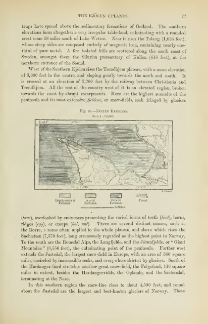
- Page 111 and 112: '.TKE KJOLEN UPLANDS. 79southern si
- Page 113 and 114: SCANDINAVIAN ISLANDS. 61to marine a
- Page 115 and 116: LIBRARY
- Page 117 and 118: THE SCANDINAVIAN FIOKDS. 83a group
- Page 119: -'$*
- Page 122 and 123: .386SCANDINAVIA.still perfect fiord
- Page 124 and 125: SCANDINAVIA.But the whole country,
- Page 126 and 127: 90 SCANDINAVIA.between "Wenersborg
- Page 128 and 129: 92 SCANDINAVIA.the western portion
- Page 130 and 131: 94 H'AXDINAVIA.day at thirteen diff
- Page 132 and 133: 96 SCANDINAVIA.North Sea with the B
- Page 134 and 135: '98 SCANDINAVIA.The Scandinavian Ri
- Page 136 and 137: 100 SCANDINAVIA.the river fill its
- Page 138: 102 SCANDINAVIA.the level of the la
- Page 142 and 143: 104 SCANDINAVIA.seas these long and
- Page 144 and 145: 106 SCANDINAVIA.falling to about 20
- Page 146 and 147: 108 SCANDINAVIA.be absolutely uninh
- Page 148 and 149: 110 SCANDINAVIA.temperate Europe.Bu
- Page 150 and 151: 112 SCANDINAVIA.the "chimrera," a g
- Page 152: 114 SCANDINAVIA.collected in the mu
- Page 156 and 157: 11GSCANDINAVIA.A mingling of the va
- Page 158:
118 SCANDINAVIA.and idioms ; but ce
- Page 161 and 162:
THE LAPPS. 119musical intonation, a
- Page 163 and 164:
NORWEGIAN TOWNS. 121their culture f
- Page 165 and 166:
NOBWEGIAN TOWNS. 123situated on the
- Page 167 and 168:
NORWEGIAN TOWNS.12ccenturies been t
- Page 169 and 170:
NORWEGIAN TOWNS. 127tennis," is the
- Page 171 and 172:
NORWEGIAN TOWNS. 129The exports of
- Page 173 and 174:
SWEDISH TOWNS. 131employed in the n
- Page 175 and 176:
SWEDISH TOWNS. 133ITveen, visible t
- Page 177 and 178:
SWEDISH TOWNS. 135tance those of Fa
- Page 180 and 181:
"•XSTOCKHOLM)Uf^-w"* . .-' T T *-
- Page 183 and 184:
SWEDISH TOWNS. 137Northwards now st
- Page 187 and 188:
SWEDISH TOWNS. 133one of the thirte
- Page 189 and 190:
SWEDISH TOWNS.Ulwas slied the blood
- Page 191 and 192:
POPULATION—EMIGRATION. 143to the
- Page 193 and 194:
AGRICULTURE—STOCK-BREEDING- FORES
- Page 195 and 196:
LAND TENURE.H7almost any forage, an
- Page 197 and 198:
FISIIEBIES.uaFisheries.The fisherie
- Page 199 and 200:
MINING INDUSTRY. 151also now being
- Page 201 and 202:
TRADE AND SHIPPING. 153industries c
- Page 203 and 204:
CANALS—EALLWAYS—EOSTAL SEEYICE.
- Page 205 and 206:
EDUCATION—SOCIAL CONDITION. 157of
- Page 207 and 208:
GOYERXMEXT AXD ADMINISTRATION OF NO
- Page 209 and 210:
GOVERNMENT AND ADMINISTRATION OF NO
- Page 211 and 212:
GOVERNMENT AND ADMINISTRATION OF SW
- Page 213 and 214:
a substitute. The regular forces (s
- Page 215 and 216:
SWEDISH ARMY AND NAVY—FINANCE. 16
- Page 217 and 218:
BEAR ISLAND.1C9the Dutchman Barents
- Page 219:
THE SUN AT MIDNIGHT, SPTTZBERGEN.
- Page 222 and 223:
172 TIIE EUROPEAN ISLANDS OF THE AE
- Page 224 and 225:
174 THE EUEOrEAN ISLANDS OF THE ARC
- Page 226 and 227:
176 TUE EUROPEAN ISLANDS OF THE ARC
- Page 228 and 229:
178 THE EUROI>EAN ISLANDS OF THE AR
- Page 230 and 231:
180 TEE EUROPEAN ISLANDS OF THE ARC
- Page 232:
132 THE EUROPEAN ISLANDS OF THE ARC
- Page 238 and 239:
184 RUSSIA IN EUROPE.extensive coas
- Page 240 and 241:
18GRUSSIA IX EUEOrE.table-land cros
- Page 242 and 243:
138 RUSSIA IX EUROPE.course down st
- Page 244 and 245:
190 RUSSIA IX EUEOPE.Black Sea. Sti
- Page 246 and 247:
192 RUSSIA IN EUEOl'E.for fifty-fou
- Page 248 and 249:
194 RUSSIA IN EUROPE.Latin transcri
- Page 250 and 251:
190 RUSSIA IN ETJBOPE.old funeral r
- Page 252 and 253:
193 BTTSSIA IN EUROPE.But many obje
- Page 254 and 255:
200 EUSSIA IN EUEOrB.Lithuanian and
- Page 256 and 257:
202 RUSSIA IN EUROPE.involved diffe
- Page 258 and 259:
204 RUSSIA IX EUBOPE.before the Rus
- Page 260 and 261:
200 RUSSIA IN EUROPE.shed on behalf
- Page 262 and 263:
208 RUSSIA IN EUROPE.plains which s
- Page 264 and 265:
210 RUSSIA IN EUROPE.under the vege
- Page 266 and 267:
212 RUSSIA IN EUROPE.Such lacustrin
- Page 268 and 269:
214 RUSSIA IN EUROPE.surroundings.
- Page 270:
216 RUSSIA IN EUEOPE.Ethnology :Tav
- Page 274 and 275:
218 EUSSIA IN EUROPE.more civilised
- Page 276 and 277:
220 RUSSIA. IN EUROPE.town, doin" -
- Page 278 and 279:
222 RUSSIA IN EUROPE.than 6,000 Rus
- Page 280 and 281:
224 RUSSIA IN EUROPE.but the want o
- Page 282 and 283:
22GKITSSIA IN EUROPE.The national r
- Page 284 and 285:
228 RUSSIA IN EUROrE.streams flow e
- Page 286 and 287:
, 10230 RUSSIA IN EUROPE.After leav
- Page 288 and 289:
232 RUSSIA IN EUROPE.The Ehstes arc
- Page 290 and 291:
234 RUSSIA IX EUROPE.below Drissa,
- Page 292:
23GRUSSIA IX EUROPE.wealthy townsfo
- Page 296:
238 RUSSIA IN EUROPE.Swedes, beside
- Page 300 and 301:
210 RUSSIA IX EUROPE.down from the
- Page 302 and 303:
242 EUSSIA IX EUROPE.century a Duch
- Page 304 and 305:
241 RUSSIA IN EUROPE.East. Yet at t
- Page 306:
24GRUSSIA IX BDEOPB.Silesia and Poz
- Page 309 and 310:
POLAND. 217Ethnical Elements.— Po
- Page 311 and 312:
POLAND. 249in the land. The Jews, a
- Page 315 and 316:
POLAND. 251by the peasantry themsel
- Page 317 and 318:
1'OLAND : WARSAW. 253and TVieprz, t
- Page 321 and 322:
POLAND: TOWNS. 255grounds and subur
- Page 323 and 324:
LITHUANIA. 257Physical Features.Fro
- Page 325 and 326:
'LITHUANIA. 259lines of erratic bou
- Page 327 and 328:
LITHUANIA2G1seaboard between the Vi
- Page 329 and 330:
LITHUANIA. 263If, on the oth->r ban
- Page 331 and 332:
LITHUANIA.•2
- Page 333 and 334:
LITHUANIA. 207interior. It was visi
- Page 335 and 336:
TEE CHEENOZOM, OR BLACK LANDS.2C9Dn
- Page 337 and 338:
THE STEPPES. 271surrounded only by
- Page 339 and 340:
THE DNIEPER. 273bluish fur from tho
- Page 341 and 342:
THE DNIEPER. 275the period of Greek
- Page 345 and 346:
THE DNIESTER. 277Tnii Dniester (Dne
- Page 347 and 348:
THE STEPPES. 270Even lakes Lave com
- Page 349 and 350:
LI1IAX3 AXD COAST-LIXE. 281float a
- Page 351 and 352:
THE WHITE RUSSIANS. 283possessions
- Page 353 and 354:
THE WHITE RUSSIANS. 285and schools
- Page 355 and 356:
YOLHYNIA: TOrOGEAPHY. 287French the
- Page 357 and 358:
THE LITTLE RUSSIANS AND COSSACKS.2S
- Page 359 and 360:
TIIE LITTLE RUSSIANS AND COSSACKS 2
- Page 363 and 364:
THE LITTLE RUSSIANS AND COSSACKS. 2
- Page 367 and 368:
TIIE COSSACKS. 295suppressed the Li
- Page 369 and 370:
FOREIGN COLONIES IN UKEANIA. 297ord
- Page 371 and 372:
FOREIGN COLONIES IN UKRANIA. 299and
- Page 373 and 374:
jitomir: 301the value of about £6,
- Page 375 and 376:
ETEV. 803Severanes, and contains a
- Page 379 and 380:
KIEV. 305which stands the church of
- Page 381 and 382:
FEREYASLAY. 307the plough of some s
- Page 383 and 384:
KBEMEXCHUG-FOLTAYA. 309wretches, wh
- Page 385 and 386:
BEBISLAY-KHEBSON. 3119itch, or stat
- Page 387 and 388:
"NIKOLAYEV—ODESSA. 313situation o
- Page 391 and 392:
ODESSA. 315on the other towards the
- Page 395 and 396:
KISHENOY— BENDER. 317the empire,
- Page 397 and 398:
CHAPTER VII.REGION OF THE GREAT LAK
- Page 399 and 400:
THE REGION OF LAKES. 821the so-call
- Page 401 and 402:
THE REGION OF LAKES. 323outflow. Fr
- Page 403 and 404:
THE REGION OF LAKES. :;2.-730 west
- Page 405 and 406:
THE EEGION OF LAKES. 827of Finland,
- Page 407 and 408:
THE REGION OF LAKES: INHABITANTS. 3
- Page 409 and 410:
TOROPETZ-SOLTZI. 331still do a year
- Page 411 and 412:
NOVGOROD. 333not all equal before t
- Page 415:
"-:-AND ENVIRONS~Kuiriii , ; I, S!
- Page 418 and 419:
iSS1A'830IX EUROPE.not one is so ha
- Page 422 and 423:
.*„;.L L Lill.Hlll iJ.JBlL .
- Page 424 and 425:
338 RUSSIA IN EUROPE.epidemics at t
- Page 426 and 427:
340 RUSSIA IN EUBOl'E.the sea, and
- Page 428 and 429:
342 RUSSIA IX EUROPE.continued east
- Page 430 and 431:
844 RUSSIA IX EUROPE.the peat beds,
- Page 432:
346 RUSSIA IX EUROPE.found both in
- Page 436 and 437:
348 RUSSIA IN EUROPE.when the ice f
- Page 438 and 439:
350 RUSSIA IX EUROPE.that however d
- Page 440 and 441:
352 RUSSIA IN EUROPE.neighbouring g
- Page 442 and 443:
8.14 EUSSIA IN EUEOPE.The Pomori, o
- Page 444 and 445:
356 RUSSIA IN EUROPE.Vologda, on th
- Page 446 and 447:
358 RUSSIA Ds EUROPE.unimportant pl
- Page 448 and 449:
300 RUSSIA IK EUROPE.Although frequ
- Page 450 and 451:
3G2RUSSIA IN EUROPE.or rusty hues o
- Page 452:
364 RUSSIA IX EUROPE.The Volga and
- Page 456 and 457:
3GGRUSSIA IN EUEOrE.equal volume, a
- Page 458 and 459:
Two hundred years ago the navigable
- Page 460 and 461:
370 RUSSIA E\ T EUKOPE.south, and r
- Page 462 and 463:
372 RUSSIA IX EUROPE.The actual lev
- Page 464 and 465:
871 RUSSIA IX EUROPE.Yelton, the Al
- Page 466 and 467:
876 RUSSIA IN EUROPE.is reached fro
- Page 468 and 469:
378 RUSSIA IX EUROPE.more than 4,00
- Page 470 and 471:
880 RUSSIA IN EUEOPE.imperial race,
- Page 472 and 473:
3S2RUSSIA IN EUROPE.communes and va
- Page 474 and 475:
S8-4 RUSSIA IN EUROPE.The Great Rus
- Page 476 and 477:
386 RUSSIA IN EUROPE.stamped papers
- Page 478 and 479:
388 RUSSIA IN EUROPE.beginning to r
- Page 480 and 481:
390 RUSSIA IN EUROPE.amount annuall
- Page 484 and 485:
TYl'ES AND COSTUilES IN TULA.
- Page 486 and 487:
302 RUSSIA IN EUROPEthe advantage o
- Page 488:
304 EUSSIA IN EUEOPE.nearly 10 mile
- Page 492 and 493:
396 EUSSIA IN EUROPE.the control of
- Page 494:
898 RUSSIA IN EUROrE.near the point
- Page 498:
400 RUSSIA IN EUROPE.kingdom, on th
- Page 502 and 503:
402 RUSSIA IN EUROPE.of a temporary
- Page 504 and 505:
404 RUSSIA IX EUBOPE.upon he takes
- Page 506 and 507:
406 RUSSIA IN EUEOPE.munities in th
- Page 508 and 509:
408 EUSSIA IN EUEOPE.much the same
- Page 510 and 511:
410 RUSSIA IN EUROPE.on the right b
- Page 512 and 513:
-412 RUSSIA IN EUROPE.In the snowy
- Page 514:
414 RUSSIA IN EUROPE.Lower Volga Ba
- Page 518 and 519:
41GEUSSIA IN EUROPE.land, burning t
- Page 520 and 521:
418 RUSSIA IN EUROPE.present it is
- Page 522 and 523:
420 RUSSIA IN EUROPE.Astrakhan, cap
- Page 524 and 525:
CHAPTER X.BASIN OF THE DON.-SEA OF
- Page 526 and 527:
424 RUSSIA IN EUBOPE.connecting the
- Page 528 and 529:
-12(5RUSSIA IN EUROPE.which at the
- Page 530 and 531:
428 RUSSIA IN EUEOPE.water is salt,
- Page 532 and 533:
430 RUSSIA IN EUROPE.from the Sivac
- Page 534 and 535:
432 RUSSIA IX EUROPE.Muscovite colo
- Page 536 and 537:
434 RUSSIA IN EUROPE.the scattered
- Page 538 and 539:
43GKUSSIA IN EUEOrE.attracting larg
- Page 540 and 541:
II438 RUSSIA IN EUROPE.the Governme
- Page 542:
4 40 EUSSIA IN EUROPE.A far better
- Page 545:
S E V A STO PO LA
- Page 548 and 549:
442 RUSSIA IN EUROPE.Geological For
- Page 550 and 551:
444 RUSSIA IN EUROPE.thus thrown up
- Page 552:
446 RUSSIA IX EUROPE.Inhabitants.Li
- Page 556:
448 RUSSIA IN EUROPE.their honesty,
- Page 560:
450 RUSSIA IN EUROPE.1864. But sinc
- Page 566 and 567:
CHAPTER XII.MATERIAL AND SOCIAL CON
- Page 568 and 569:
454 RUSSIA IN EUROPE.The Russians g
- Page 570 and 571:
456 RUSSIA IN EUROPE.Most of the to
- Page 572 and 573:
WhiteLakes458 KUSSIA IN EUEOPE.Indu
- Page 574 and 575:
400 RUSSIA IN EUROPE.seed, the tota
- Page 576 and 577:
4G2RUSSIA IN ETJEOPE.At the same ti
- Page 578 and 579:
4C1RUSSIA IX EUROPE.becomes a villa
- Page 580 and 581:
4GGRUSSIA IN EUROPE.the tallow indu
- Page 582 and 583:
466 RUSSIA IN EUKOrE.2,000 Ions, th
- Page 584 and 585:
470 EUSSIA IN EUEOrE.it is surpasse
- Page 586 and 587:
472 BUSSIA IN EUROPE.science is als
- Page 588 and 589:
171 RUSSIA IN EUROPE.the charitable
- Page 590 and 591:
470 KTTSSIA IN EUROPE.the uprava, o
- Page 592 and 593:
478 RUSSIA IN EUROPE.war. Before 18
- Page 594 and 595:
480 RUSSIA IN EUROPE.to £2,000,000
- Page 596 and 597:
482 APPEXDIX.n.—COMMEECE.Mercanti
- Page 598 and 599:
484 A1TEXDIX.THE EUSSIAN EMPIEE.I.
- Page 600 and 601:
48GAPPENDIX.Religions in the Russia
- Page 602 and 603:
48SAPPENDIX.THE FT SSI AN NAVY.Balt
- Page 604 and 605:
490 INDEX.Brunkebergs 5s, 91Brzcnzi
- Page 606 and 607:
1Kranholm492 INDEX.Kara-Kalpaks, 29
- Page 608 and 609:
494 INDEX.Pinsk, 287Marsh, 271Poitr
- Page 610:
496 INDEX.Vardo, 129Varduhus, 168Va
- Page 615 and 616:
1%'~Mm>wmm ®Mmm^m^mSm^t:


![The Philosophy of Progress [pdf]](https://img.yumpu.com/14077359/1/190x245/the-philosophy-of-progress-pdf.jpg?quality=85)