<str<strong>on</strong>g>Proceedings</str<strong>on</strong>g> <str<strong>on</strong>g>of</str<strong>on</strong>g> <str<strong>on</strong>g>the</str<strong>on</strong>g> <str<strong>on</strong>g>Third</str<strong>on</strong>g> <str<strong>on</strong>g>Internati<strong>on</strong>al</str<strong>on</strong>g> <str<strong>on</strong>g>C<strong>on</strong>ference</str<strong>on</strong>g> <strong>on</strong> <strong>Invasive</strong> SpartinaChapter 3: Ecosystem Effects <str<strong>on</strong>g>of</str<strong>on</strong>g> <strong>Invasive</strong> SpartinaPOTENTIAL IMPACTS OF SPARTINA SPREAD ON SHOREBIRD POPULATIONS IN SOUTH SANFRANCISCO BAYD. STRALBERG 1 , V. TONIOLO 1,2 , G.W. PAGE 1 , AND L.E. STENZEL 11 PRBO C<strong>on</strong>servati<strong>on</strong> Science, 3820 Cypress Drive #11, Petaluma, CA 94954, dstralberg@prbo.org2 Current address: Ocean Biogeochemistry Lab, Dept. <str<strong>on</strong>g>of</str<strong>on</strong>g> Envir<strong>on</strong>mental Earth System Science, Mitchell Bldg, A67, StanfordUniversity Stanford, CA 94305-2215San Francisco Bay holds 70% <str<strong>on</strong>g>of</str<strong>on</strong>g> California’s mudflats and provides habitat to more wintering andmigratory shorebirds than any o<str<strong>on</strong>g>the</str<strong>on</strong>g>r wetland al<strong>on</strong>g <str<strong>on</strong>g>the</str<strong>on</strong>g> Pacific coast <str<strong>on</strong>g>of</str<strong>on</strong>g> <str<strong>on</strong>g>the</str<strong>on</strong>g> c<strong>on</strong>tiguous U.S. The bay’smudflats are currently threatened by <str<strong>on</strong>g>the</str<strong>on</strong>g> spread <str<strong>on</strong>g>of</str<strong>on</strong>g> a n<strong>on</strong>-native cordgrass, Spartina alterniflora, andassociated hybrids, which grow at lower elevati<strong>on</strong>s than <str<strong>on</strong>g>the</str<strong>on</strong>g> native S. foliosa and can render largemudflat areas effectively unavailable to shorebirds for foraging. Using shorebird survey data, tidestati<strong>on</strong> data, and GIS-based habitat data, we analyzed <str<strong>on</strong>g>the</str<strong>on</strong>g> potential effect <str<strong>on</strong>g>of</str<strong>on</strong>g> S. alterniflora x foliosahybrids <strong>on</strong> shorebird habitat in <str<strong>on</strong>g>the</str<strong>on</strong>g> South Bay by creating grid-based spatial models <str<strong>on</strong>g>of</str<strong>on</strong>g> shorebirdhabitat value and potential Spartina spread. We developed three scenarios <str<strong>on</strong>g>of</str<strong>on</strong>g> potential habitat valueloss for shorebirds based <strong>on</strong> assumpti<strong>on</strong>s about <str<strong>on</strong>g>the</str<strong>on</strong>g> inundati<strong>on</strong> tolerance <str<strong>on</strong>g>of</str<strong>on</strong>g> S. alterniflora and temporalavailability <str<strong>on</strong>g>of</str<strong>on</strong>g> mudflat resources. Predicti<strong>on</strong>s <str<strong>on</strong>g>of</str<strong>on</strong>g> habitat value loss across seas<strong>on</strong>s ranged from27% to 80%. We identified <str<strong>on</strong>g>the</str<strong>on</strong>g> upper mudflats, due to <str<strong>on</strong>g>the</str<strong>on</strong>g>ir greater exposure time, and <str<strong>on</strong>g>the</str<strong>on</strong>g> east andsouth shore mudflats, due to <str<strong>on</strong>g>the</str<strong>on</strong>g> high numbers <str<strong>on</strong>g>of</str<strong>on</strong>g> birds detected <str<strong>on</strong>g>the</str<strong>on</strong>g>re, as <str<strong>on</strong>g>the</str<strong>on</strong>g> areas <str<strong>on</strong>g>of</str<strong>on</strong>g> highest valueto shorebirds in <str<strong>on</strong>g>the</str<strong>on</strong>g> South Bay. These areas also coincide with <str<strong>on</strong>g>the</str<strong>on</strong>g> areas <str<strong>on</strong>g>of</str<strong>on</strong>g> greatest Spartina invasi<strong>on</strong>potential.Keywords: Spartina alterniflora, mudflats, inundati<strong>on</strong> tolerance, Charadrii, GISINTRODUCTIONThe San Francisco Bay estuary holds 70% <str<strong>on</strong>g>of</str<strong>on</strong>g> <str<strong>on</strong>g>the</str<strong>on</strong>g> mudflatsin California (Josselyn et al. 1990), providing habitatto over 350,000 migrating shorebirds (Charadrii) in <str<strong>on</strong>g>the</str<strong>on</strong>g>fall, over 325,000 in winter, and over 900,000 in <str<strong>on</strong>g>the</str<strong>on</strong>g> spring(based <strong>on</strong> single-day counts) (Stenzel et al. 2002). Al<strong>on</strong>g <str<strong>on</strong>g>the</str<strong>on</strong>g>Pacific coast <str<strong>on</strong>g>of</str<strong>on</strong>g> <str<strong>on</strong>g>the</str<strong>on</strong>g> c<strong>on</strong>tiguous United States al<strong>on</strong>e (excludingAlaska), San Francisco Bay holds more shorebirds thanany o<str<strong>on</strong>g>the</str<strong>on</strong>g>r wetland in all seas<strong>on</strong>s (Page et al. 1999). Surveydata suggest that San Francisco Bay holds over 50% <str<strong>on</strong>g>of</str<strong>on</strong>g> <str<strong>on</strong>g>the</str<strong>on</strong>g>Pacific coast populati<strong>on</strong>s <str<strong>on</strong>g>of</str<strong>on</strong>g> several shorebird species—11<str<strong>on</strong>g>of</str<strong>on</strong>g> <str<strong>on</strong>g>the</str<strong>on</strong>g> 12 most abundant species in fall, six <str<strong>on</strong>g>of</str<strong>on</strong>g> 13 in winter,and seven <str<strong>on</strong>g>of</str<strong>on</strong>g> 13 in spring (Page et al. 1999). Within <str<strong>on</strong>g>the</str<strong>on</strong>g> Bay,mudflats are <str<strong>on</strong>g>the</str<strong>on</strong>g> most important habitats for <str<strong>on</strong>g>the</str<strong>on</strong>g> majority <str<strong>on</strong>g>of</str<strong>on</strong>g><str<strong>on</strong>g>the</str<strong>on</strong>g>se species (Stenzel et al. 2002).San Francisco Bay’s mudflats are now threatened by<str<strong>on</strong>g>the</str<strong>on</strong>g> spread <str<strong>on</strong>g>of</str<strong>on</strong>g> cordgrass hybrids (Spartina alterniflora xfoliosa) (Ayres et al. 2008). The n<strong>on</strong>-native S. alterniflorawas originally introduced to <str<strong>on</strong>g>the</str<strong>on</strong>g> South San Francisco Bay(South Bay) in <str<strong>on</strong>g>the</str<strong>on</strong>g> 1970s (Callaway and Josselyn 1992) andhybridized with native S. foliosa (Ayres et al. 1999). Spartinaalterniflora x foliosa hybrids exhibit higher tolerance totidal submersi<strong>on</strong> and salinity, as well as higher growth andgerminati<strong>on</strong> rates than <str<strong>on</strong>g>the</str<strong>on</strong>g> native S. foliosa (Callaway andJosselyn 1992; Daehler and Str<strong>on</strong>g 1997; Anttila et al. 1998;Collins 2002). Projecti<strong>on</strong>s from sampling sites suggested thatnearly 800 hectares (ha) <str<strong>on</strong>g>of</str<strong>on</strong>g> South Bay marshes, channels,and mudflats had been invaded by 2003, an increase <str<strong>on</strong>g>of</str<strong>on</strong>g> morethan 300% since 2001 (Zaremba et al., this volume). Fur<str<strong>on</strong>g>the</str<strong>on</strong>g>rspread <str<strong>on</strong>g>of</str<strong>on</strong>g> hybrid Spartina <strong>on</strong> <str<strong>on</strong>g>the</str<strong>on</strong>g> Bay’s mudflats poses a greatthreat to shorebirds, which cannot forage in areas <str<strong>on</strong>g>of</str<strong>on</strong>g> densegrowth (Josselyn 1983, Evans 1986, Goss-Custard and Moser1988, White 1995).In Willapa Bay, Washingt<strong>on</strong>, which was initiallyinvaded in <str<strong>on</strong>g>the</str<strong>on</strong>g> late 19th century, S. alterniflora recentlyexperienced explosive growth, tripling its areal extentbetween 1994 and 2002 and c<strong>on</strong>verting many mudflats toSpartina marshes (Buchanan 2003; Civille 2005). Surveys<str<strong>on</strong>g>of</str<strong>on</strong>g> Willapa Bay birds suggested a reducti<strong>on</strong> in shorebirdnumbers by as much as 67% and foraging time by as muchas 50% (Jaques 2002). Unlike San Francisco Bay, WillapaBay is outside <str<strong>on</strong>g>the</str<strong>on</strong>g> range <str<strong>on</strong>g>of</str<strong>on</strong>g> native Spartina and <str<strong>on</strong>g>the</str<strong>on</strong>g>reforehas no hybrid Spartina, which has been found to exhibitmuch more rapid rates <str<strong>on</strong>g>of</str<strong>on</strong>g> lateral expansi<strong>on</strong> than its parentalspecies (Ayres et al. 2008). Thus <str<strong>on</strong>g>the</str<strong>on</strong>g> invasi<strong>on</strong> potential inSan Francisco Bay is thought to be substantially greaterthan in Willapa Bay.While San Francisco Bay and Willapa Bay also differin <str<strong>on</strong>g>the</str<strong>on</strong>g>ir bathymetry and tidal inundati<strong>on</strong> regimes, relati<strong>on</strong>shipsthat have been identified between tidal inundati<strong>on</strong>parameters and S. alterniflora growth tolerance (McKeeand Patrick 1988; Collins 2002) may be used to estimate <str<strong>on</strong>g>the</str<strong>on</strong>g>potential for hybrid Spartina spread in San Francisco Bay.Here we present a preliminary GIS-based analysis <str<strong>on</strong>g>of</str<strong>on</strong>g> <str<strong>on</strong>g>the</str<strong>on</strong>g>potential effects <str<strong>on</strong>g>of</str<strong>on</strong>g> hybrid Spartina <strong>on</strong> shorebird habitat inSouth San Francisco Bay (<str<strong>on</strong>g>the</str<strong>on</strong>g> South Bay), using grid-basedspatial models <str<strong>on</strong>g>of</str<strong>on</strong>g> (a) shorebird habitat value and (b) potentialSpartina spread.- 175 -
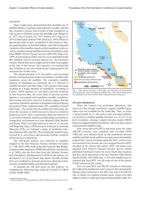
Chapter 3: Ecosystem Effects <str<strong>on</strong>g>of</str<strong>on</strong>g> <strong>Invasive</strong> Spartina<str<strong>on</strong>g>Proceedings</str<strong>on</strong>g> <str<strong>on</strong>g>of</str<strong>on</strong>g> <str<strong>on</strong>g>the</str<strong>on</strong>g> <str<strong>on</strong>g>Third</str<strong>on</strong>g> <str<strong>on</strong>g>Internati<strong>on</strong>al</str<strong>on</strong>g> <str<strong>on</strong>g>C<strong>on</strong>ference</str<strong>on</strong>g> <strong>on</strong> <strong>Invasive</strong> SpartinaMETHODSMany studies have dem<strong>on</strong>strated that shorebird use <str<strong>on</strong>g>of</str<strong>on</strong>g>mudflat habitats is spatially and temporally variable, and thatthis variati<strong>on</strong> is closely tied to cycles <str<strong>on</strong>g>of</str<strong>on</strong>g> tidal inundati<strong>on</strong>, aswell as prey availability across <str<strong>on</strong>g>the</str<strong>on</strong>g> intertidal z<strong>on</strong>e (Burger etal. 1977; Goss-Custard et al. 1977; Puttick 1977; Page et al.1979; Colwell and Landrum 1993; Yates et al. 1993). While wedid not have data <strong>on</strong> prey availability in San Francisco Bay,our quantificati<strong>on</strong> <str<strong>on</strong>g>of</str<strong>on</strong>g> shorebird habitat value did incorporatevariati<strong>on</strong> within mudflats based <strong>on</strong> tidal inundati<strong>on</strong> cycles, aswell as variati<strong>on</strong> am<strong>on</strong>g mudflats based <strong>on</strong> shorebird use datafrom PRBO’s Pacific Flyway surveys (1988-1993, Page et al.1999). For <str<strong>on</strong>g>the</str<strong>on</strong>g> purpose <str<strong>on</strong>g>of</str<strong>on</strong>g> this exercise, we assumed that SouthBay mudflats were at carrying capacity (i.e., <str<strong>on</strong>g>the</str<strong>on</strong>g> maximumnumber <str<strong>on</strong>g>of</str<strong>on</strong>g> birds that can be supported by a finite food supply)at <str<strong>on</strong>g>the</str<strong>on</strong>g> time <str<strong>on</strong>g>of</str<strong>on</strong>g> <str<strong>on</strong>g>the</str<strong>on</strong>g> surveys. By extensi<strong>on</strong>, we assumed thatloss <str<strong>on</strong>g>of</str<strong>on</strong>g> habitat in <strong>on</strong>e area would not be compensated for byincreased use <str<strong>on</strong>g>of</str<strong>on</strong>g> o<str<strong>on</strong>g>the</str<strong>on</strong>g>r areas.The spread potential <str<strong>on</strong>g>of</str<strong>on</strong>g> S. alterniflora and associatedhybrids was based <strong>on</strong> percentiles <str<strong>on</strong>g>of</str<strong>on</strong>g> cumulative m<strong>on</strong>thly tidalinundati<strong>on</strong> across <str<strong>on</strong>g>the</str<strong>on</strong>g> mudflats. The cumulative m<strong>on</strong>thlydurati<strong>on</strong> <str<strong>on</strong>g>of</str<strong>on</strong>g> inundati<strong>on</strong> at a particular site is a functi<strong>on</strong> <str<strong>on</strong>g>of</str<strong>on</strong>g>mudflat elevati<strong>on</strong> and tidal range, with a greater tidal rangeresulting in a l<strong>on</strong>ger durati<strong>on</strong> <str<strong>on</strong>g>of</str<strong>on</strong>g> inundati<strong>on</strong>. According toCollins’ (2002) analyses <str<strong>on</strong>g>of</str<strong>on</strong>g> n<strong>on</strong>-native Spartina locati<strong>on</strong>sin San Francisco Bay, <str<strong>on</strong>g>the</str<strong>on</strong>g> lower limit <str<strong>on</strong>g>of</str<strong>on</strong>g> Spartina growthappears to corresp<strong>on</strong>d with cumulative m<strong>on</strong>thly inundati<strong>on</strong>,and existing n<strong>on</strong>-native Spartina locati<strong>on</strong>s suggest that <str<strong>on</strong>g>the</str<strong>on</strong>g>maximum cumulative durati<strong>on</strong> <str<strong>on</strong>g>of</str<strong>on</strong>g> inundati<strong>on</strong> tolerated during<str<strong>on</strong>g>the</str<strong>on</strong>g> m<strong>on</strong>th <str<strong>on</strong>g>of</str<strong>on</strong>g> June is approximately 70%, regardless <str<strong>on</strong>g>of</str<strong>on</strong>g> meantidal range. 1 This means that <str<strong>on</strong>g>the</str<strong>on</strong>g> smaller <str<strong>on</strong>g>the</str<strong>on</strong>g> tidal range, <str<strong>on</strong>g>the</str<strong>on</strong>g>lower <str<strong>on</strong>g>the</str<strong>on</strong>g> elevati<strong>on</strong> at which n<strong>on</strong>-native Spartina would bepredicted to grow. Due to uncertainty about <str<strong>on</strong>g>the</str<strong>on</strong>g> behavior <str<strong>on</strong>g>of</str<strong>on</strong>g>S. alterniflora hybrids, and because <str<strong>on</strong>g>the</str<strong>on</strong>g>se plants are known tochange <str<strong>on</strong>g>the</str<strong>on</strong>g>ir envir<strong>on</strong>ment over time (Ranwell 1964; Daehlerand Str<strong>on</strong>g 1996), accreting sediment at rates <str<strong>on</strong>g>of</str<strong>on</strong>g> 1-2 cm/yearin Willapa Bay (Sayce 1988) and up to 4 cm/year in Australia(Bascand 1970), we evaluated a range <str<strong>on</strong>g>of</str<strong>on</strong>g> inundati<strong>on</strong> tolerancesbetween 60% and 80%. We assumed that mudflat areascovered by S. alterniflora and associated hybrids would beeffectively lost to shorebirds.Our GIS-based analysis was restricted to mudflatsmapped by <str<strong>on</strong>g>the</str<strong>on</strong>g> San Francisco Estuary Institute’s EcoAtlas(v. 1.50b, SFEI 1998) south <str<strong>on</strong>g>of</str<strong>on</strong>g> <str<strong>on</strong>g>the</str<strong>on</strong>g> San Francisco Bay Bridge.Using EcoAtlas map layers, PRBO shorebird surveys (Stenzelet al. 2002), and tide level data from <str<strong>on</strong>g>the</str<strong>on</strong>g> Nati<strong>on</strong>al Oceanicand Atmospheric Administrati<strong>on</strong>’s (NOAA) tide stati<strong>on</strong>s, wedeveloped a set <str<strong>on</strong>g>of</str<strong>on</strong>g> grid-based data layers (ArcInfo format)that were combined to generate predicti<strong>on</strong>s about <str<strong>on</strong>g>the</str<strong>on</strong>g> potentialloss <str<strong>on</strong>g>of</str<strong>on</strong>g> mudflat habitat and shorebird numbers.To generate <str<strong>on</strong>g>the</str<strong>on</strong>g> GIS grid layers for this analysis, wecompleted <str<strong>on</strong>g>the</str<strong>on</strong>g> following steps using <str<strong>on</strong>g>the</str<strong>on</strong>g> ArcInfo 8.3 GRIDmodule (ESRI 2002).1 Initial estimates <str<strong>on</strong>g>of</str<strong>on</strong>g> 40% presented in Collins (2002) have since been revised.Fig. 1. Tide stati<strong>on</strong> locati<strong>on</strong>s, stati<strong>on</strong> IDs, and allocati<strong>on</strong> <str<strong>on</strong>g>of</str<strong>on</strong>g> tide stati<strong>on</strong>swith c<strong>on</strong>tinuous water level data to mudflat areas. Tide stati<strong>on</strong> informati<strong>on</strong>was obtained from NOAA/NOS (http://tidesandcurrents.noaa.gov/).Elevati<strong>on</strong>/BathymetryWhen this analysis was performed, bathymetry datalayers <str<strong>on</strong>g>of</str<strong>on</strong>g> a fine enough resoluti<strong>on</strong> to capture mudflat topographywere not available for <str<strong>on</strong>g>the</str<strong>on</strong>g> South Bay. Thus, to createa spread model for S. alterniflora and associated hybrids,we elected to estimate mudflat elevati<strong>on</strong> at a 3x3 m 2 (3-m)pixel resoluti<strong>on</strong>, creating a digital elevati<strong>on</strong> model (DEM)based <strong>on</strong> mapped mudflat boundaries, tide level data, and anassumed linear mudflat slope.First, mean tide level (MTL) and mean lower low water(MLLW) c<strong>on</strong>tours were estimated from EcoAtlas (SFEI1998) and were defined based <strong>on</strong> <str<strong>on</strong>g>the</str<strong>on</strong>g> boundaries betweenmudflat and tidal marsh and between open water and mudflat,respectively. Actual elevati<strong>on</strong>s al<strong>on</strong>g <str<strong>on</strong>g>the</str<strong>on</strong>g> MTL c<strong>on</strong>tour werenot assumed to be c<strong>on</strong>stant, but were assigned based <strong>on</strong> MTLelevati<strong>on</strong> at <str<strong>on</strong>g>the</str<strong>on</strong>g> closest tide stati<strong>on</strong>. MTL elevati<strong>on</strong>s wereobtained from NOAA’s Nati<strong>on</strong>al Oceanic Service (NOS)published benchmark sheets for seven South Bay locati<strong>on</strong>sthat have been referenced to <str<strong>on</strong>g>the</str<strong>on</strong>g> new Nati<strong>on</strong>al Tidal DatumEpoch (NTDE; 1983-2001) (Fig. 1). For each mudflat area weassumed that local MTL was <str<strong>on</strong>g>the</str<strong>on</strong>g> same as that <str<strong>on</strong>g>of</str<strong>on</strong>g> <str<strong>on</strong>g>the</str<strong>on</strong>g> nearestNTDE-referenced tide stati<strong>on</strong>.Next we used MTL and MLLW c<strong>on</strong>tours to determine<str<strong>on</strong>g>the</str<strong>on</strong>g> width <str<strong>on</strong>g>of</str<strong>on</strong>g> <str<strong>on</strong>g>the</str<strong>on</strong>g> mudflat for each 3-m pixel. We calculated <str<strong>on</strong>g>the</str<strong>on</strong>g>distance from each pixel to <str<strong>on</strong>g>the</str<strong>on</strong>g> MTL line and to <str<strong>on</strong>g>the</str<strong>on</strong>g> MLLWline, to obtain two separate distance grids, which were <str<strong>on</strong>g>the</str<strong>on</strong>g>nadded to obtain a single grid representing mudflat width. For- 176 -
- Page 2 and 3:
Proceedings <stron
- Page 4 and 5:
FORWARD & ACKNOWLEDGEMENTSThe <stro
- Page 6 and 7:
TABLE OF CONTENTSForward & Acknowle
- Page 9 and 10:
Community Spartina Education and St
- Page 11 and 12:
included the docum
- Page 14:
CHAPTER ONESpartina Biology
- Page 17 and 18:
Chapter 1: Spartina Biology
- Page 19 and 20:
Chapter 1: Spartina Biology
- Page 21 and 22:
Chapter 1: Spartina Biology
- Page 23 and 24:
Chapter 1: Spartina Biology
- Page 25 and 26:
Chapter 1: Spartina Biology
- Page 28 and 29:
Proceedings <stron
- Page 30 and 31:
Proceedings <stron
- Page 32 and 33:
Proceedings <stron
- Page 34:
Proceedings <stron
- Page 37 and 38:
Chapter 1: Spartina Biology
- Page 39 and 40:
Chapter 1: Spartina Biology
- Page 42 and 43:
Proceedings <stron
- Page 44:
Proceedings <stron
- Page 47 and 48:
Chapter 1: Spartina Biology
- Page 49 and 50:
Chapter 1: Spartina Biology
- Page 51 and 52:
Chapter 1: Spartina Biology
- Page 53 and 54:
Chapter 1: Spartina Biology
- Page 55 and 56:
Chapter 1: Spartina Biology
- Page 57 and 58:
Chapter 1: Spartina Biology
- Page 60 and 61:
Proceedings <stron
- Page 62 and 63:
Proceedings <stron
- Page 64 and 65:
Proceedings <stron
- Page 66:
Proceedings <stron
- Page 69 and 70:
Chapter 1: Spartina Biology
- Page 71 and 72:
Chapter 1: Spartina Biology
- Page 74 and 75:
Proceedings <stron
- Page 76:
Proceedings <stron
- Page 79 and 80:
Chapter 2: Spartina Distribution an
- Page 81 and 82:
Chapter 2: Spartina Distribution an
- Page 83 and 84:
Chapter 2: Spartina Distribution an
- Page 86 and 87:
Proceedings <stron
- Page 88 and 89:
Proceedings <stron
- Page 90 and 91:
Proceedings <stron
- Page 92 and 93:
Proceedings <stron
- Page 94 and 95:
Proceedings <stron
- Page 96 and 97:
Proceedings <stron
- Page 98:
Proceedings <stron
- Page 101 and 102:
Chapter 2: Spartina Distribution an
- Page 103 and 104:
Chapter 2: Spartina Distribution an
- Page 105 and 106:
Chapter 2: Spartina Distribution an
- Page 108 and 109:
Proceedings <stron
- Page 110:
Proceedings <stron
- Page 113 and 114:
Chapter 2: Spartina Distribution an
- Page 115 and 116:
Chapter 2: Spartina Distribution an
- Page 117 and 118:
Chapter 2: Spartina Distribution an
- Page 119 and 120:
Chapter 2: Spartina Distribution an
- Page 122 and 123:
Proceedings <stron
- Page 124 and 125:
Proceedings <stron
- Page 126 and 127:
Proceedings <stron
- Page 128:
Proceedings <stron
- Page 131 and 132:
Chapter 2: Spartina Distribution an
- Page 134 and 135:
Proceedings <stron
- Page 136 and 137:
Proceedings <stron
- Page 138 and 139: Proceedings <stron
- Page 140: CHAPTER THREEEcosystem Effects <str
- Page 143 and 144: Chapter 3: Ecosystem Effects <stron
- Page 145 and 146: Chapter 3: Ecosystem Effects <stron
- Page 148 and 149: Proceedings <stron
- Page 150 and 151: Proceedings <stron
- Page 152: Proceedings <stron
- Page 155 and 156: Chapter 3: Ecosystem Effects <stron
- Page 157 and 158: Chapter 3: Ecosystem Effects <stron
- Page 160 and 161: Proceedings <stron
- Page 162 and 163: Proceedings <stron
- Page 164: Proceedings <stron
- Page 167 and 168: Chapter 3: Ecosystem Effects <stron
- Page 169 and 170: Chapter 3: Ecosystem Effects <stron
- Page 171 and 172: Chapter 3: Ecosystem Effects <stron
- Page 174 and 175: Proceedings <stron
- Page 176: Proceedings <stron
- Page 179 and 180: Chapter 3: Ecosystem Effects <stron
- Page 181 and 182: Chapter 3: Ecosystem Effects <stron
- Page 184 and 185: Proceedings <stron
- Page 186 and 187: Proceedings <stron
- Page 190 and 191: Proceedings <stron
- Page 192 and 193: Proceedings <stron
- Page 194 and 195: Proceedings <stron
- Page 196: Proceedings <stron
- Page 199 and 200: Chapter 3: Ecosystem Effects <stron
- Page 201 and 202: Chapter 3: Ecosystem Effects <stron
- Page 204 and 205: Proceedings <stron
- Page 206 and 207: Proceedings <stron
- Page 208 and 209: Proceedings <stron
- Page 210 and 211: Proceedings <stron
- Page 212: Proceedings <stron
- Page 216 and 217: Proceedings <stron
- Page 218 and 219: Proceedings <stron
- Page 220 and 221: Proceedings <stron
- Page 222 and 223: Proceedings <stron
- Page 224 and 225: Proceedings <stron
- Page 226 and 227: Proceedings <stron
- Page 228 and 229: Proceedings <stron
- Page 230 and 231: Proceedings <stron
- Page 232 and 233: Proceedings <stron
- Page 234 and 235: Proceedings <stron
- Page 236 and 237: Proceedings <stron
- Page 238 and 239:
Proceedings <stron
- Page 240 and 241:
Proceedings <stron
- Page 242 and 243:
Proceedings <stron
- Page 244 and 245:
Proceedings <stron
- Page 246:
Proceedings <stron
- Page 249 and 250:
Chapter 4: Spartina Control and Man
- Page 251 and 252:
Chapter 4: Spartina Control and Man
- Page 253 and 254:
Chapter 4: Spartina Control and Man
- Page 255 and 256:
Chapter 4: Spartina Control and Man
- Page 257 and 258:
Chapter 4: Spartina Control and Man
- Page 259 and 260:
Chapter 4: Spartina Control and Man
- Page 261 and 262:
Chapter 4: Spartina Control and Man
- Page 263 and 264:
Chapter 4: Spartina Control and Man
- Page 265 and 266:
Chapter 4: Spartina Control and Man
- Page 267 and 268:
Chapter 4: Spartina Control and Man
- Page 269 and 270:
Chapter 4: Spartina Control and Man
- Page 271 and 272:
Chapter 4: Spartina Control and Man
- Page 273 and 274:
Chapter 4: Spartina Control and Man
- Page 276 and 277:
Proceedings <stron
- Page 278 and 279:
Proceedings <stron
- Page 280 and 281:
Proceedings <stron
- Page 282 and 283:
Proceedings <stron
- Page 284 and 285:
Proceedings <stron
- Page 286 and 287:
Proceedings <stron
- Page 288 and 289:
Proceedings <stron
- Page 290:
Proceedings <stron