Proceedings of the Third International Conference on Invasive ...
Proceedings of the Third International Conference on Invasive ...
Proceedings of the Third International Conference on Invasive ...
- No tags were found...

You also want an ePaper? Increase the reach of your titles
YUMPU automatically turns print PDFs into web optimized ePapers that Google loves.
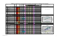
Chapter 4: Spartina C<strong>on</strong>trol and Management<str<strong>on</strong>g>Proceedings</str<strong>on</strong>g> <str<strong>on</strong>g>of</str<strong>on</strong>g> <str<strong>on</strong>g>the</str<strong>on</strong>g> <str<strong>on</strong>g>Third</str<strong>on</strong>g> <str<strong>on</strong>g>Internati<strong>on</strong>al</str<strong>on</strong>g> <str<strong>on</strong>g>C<strong>on</strong>ference</str<strong>on</strong>g> <strong>on</strong> <strong>Invasive</strong> Spartinaanalytic services are <str<strong>on</strong>g>of</str<strong>on</strong>g>ten very expensive. Most agencieshave geographic informati<strong>on</strong> system (GIS) expertise, but<str<strong>on</strong>g>the</str<strong>on</strong>g>y are assigned to <str<strong>on</strong>g>the</str<strong>on</strong>g> highest priority projects for <str<strong>on</strong>g>the</str<strong>on</strong>g>agency. The Spartina infestati<strong>on</strong> was not c<strong>on</strong>sidered to besufficiently important to justify dedicati<strong>on</strong> <str<strong>on</strong>g>of</str<strong>on</strong>g> internal GISservices by any <str<strong>on</strong>g>of</str<strong>on</strong>g> Washingt<strong>on</strong>’s state agencies. Fortunately,precisi<strong>on</strong> is not critical. You really d<strong>on</strong>’t need maps andanalysis worthy <str<strong>on</strong>g>of</str<strong>on</strong>g> scientific publicati<strong>on</strong>s. For that reas<strong>on</strong>, Ibelieve that <str<strong>on</strong>g>the</str<strong>on</strong>g> use <str<strong>on</strong>g>of</str<strong>on</strong>g> standard-accuracy Global Positi<strong>on</strong>ingSystem (GPS) technology is an acceptable way to map formanagement purposes. We found that a basic survey <str<strong>on</strong>g>of</str<strong>on</strong>g>Willapa Bay could be d<strong>on</strong>e in seven-day period bydelineating <str<strong>on</strong>g>the</str<strong>on</strong>g> outer edge <str<strong>on</strong>g>of</str<strong>on</strong>g> <str<strong>on</strong>g>the</str<strong>on</strong>g> infestati<strong>on</strong> using a GPSunit. GPS surveys are inherently ground-tru<str<strong>on</strong>g>the</str<strong>on</strong>g>d and georeferenced.The data from a GPS survey can be easilyexported and displayed as a GIS layer. Our total cost wasless than $2,000. Infrared aerial photography and itsinterpretati<strong>on</strong>, by comparis<strong>on</strong>, was so expensive thatagencies could <strong>on</strong>ly afford to have it d<strong>on</strong>e every third year.Image processing and interpretati<strong>on</strong> required years <str<strong>on</strong>g>of</str<strong>on</strong>g> work.Katy Zaremba presented informati<strong>on</strong> earlier in this Spartinac<strong>on</strong>ference indicating that aerial photography misses a greatmany plants. While aerial photography may have academicvalue, I believe that we have learned that it is not <str<strong>on</strong>g>the</str<strong>on</strong>g> optimalway to serve day-to-day management needs.In terms <str<strong>on</strong>g>of</str<strong>on</strong>g> quantity, however, I would say that it wouldbe difficult to have too many maps. During <str<strong>on</strong>g>the</str<strong>on</strong>g> first fiveyears <str<strong>on</strong>g>of</str<strong>on</strong>g> <str<strong>on</strong>g>the</str<strong>on</strong>g> Willapa Spartina program, we had too few. It isbest to have surveys d<strong>on</strong>e at <str<strong>on</strong>g>the</str<strong>on</strong>g> beginning as well as at <str<strong>on</strong>g>the</str<strong>on</strong>g>end <str<strong>on</strong>g>of</str<strong>on</strong>g> each seas<strong>on</strong>. I would recommend that you have GISand GPS services at your beck and call. You’ll need maps toresp<strong>on</strong>d quickly to new challenges as <str<strong>on</strong>g>the</str<strong>on</strong>g>y arise.For example, in 2002, Dr. Kim Patten <str<strong>on</strong>g>of</str<strong>on</strong>g> Washingt<strong>on</strong>State University c<strong>on</strong>cluded that herbicide applicati<strong>on</strong>s would<strong>on</strong>ly deliver optimal kill rates if a minimum <str<strong>on</strong>g>of</str<strong>on</strong>g> 12 hours <str<strong>on</strong>g>of</str<strong>on</strong>g>dry time followed treatment. Our challenge was to determinewhe<str<strong>on</strong>g>the</str<strong>on</strong>g>r Spartina in <str<strong>on</strong>g>the</str<strong>on</strong>g> lowest elevati<strong>on</strong>s <str<strong>on</strong>g>of</str<strong>on</strong>g> Willapa Baywere exposed for at least 12 hours during any <str<strong>on</strong>g>of</str<strong>on</strong>g> <str<strong>on</strong>g>the</str<strong>on</strong>g> tidesexpected in <str<strong>on</strong>g>the</str<strong>on</strong>g> upcoming seas<strong>on</strong>. Using <str<strong>on</strong>g>the</str<strong>on</strong>g> new LiDARbathymetry layer generated through <str<strong>on</strong>g>the</str<strong>on</strong>g> University <str<strong>on</strong>g>of</str<strong>on</strong>g>California at Davis and <str<strong>on</strong>g>the</str<strong>on</strong>g> NOAA Coastal Services Centerproject, Teresa Alcock and Keven Bennett <str<strong>on</strong>g>of</str<strong>on</strong>g> <str<strong>on</strong>g>the</str<strong>on</strong>g> University<str<strong>on</strong>g>of</str<strong>on</strong>g> Washingt<strong>on</strong>’s Olympic Natural Resources Center(ONRC) formulated a method for presenting spatiallyexplicittidal predicti<strong>on</strong>s. Ano<str<strong>on</strong>g>the</str<strong>on</strong>g>r example <str<strong>on</strong>g>of</str<strong>on</strong>g> a spatialinformati<strong>on</strong> challenge was <str<strong>on</strong>g>the</str<strong>on</strong>g> identificati<strong>on</strong> <str<strong>on</strong>g>of</str<strong>on</strong>g> owners <str<strong>on</strong>g>of</str<strong>on</strong>g>infested parcels. In many areas <str<strong>on</strong>g>of</str<strong>on</strong>g> Willapa Bay, <str<strong>on</strong>g>the</str<strong>on</strong>g> pattern<str<strong>on</strong>g>of</str<strong>on</strong>g> ownership is extremely complex with hundreds <str<strong>on</strong>g>of</str<strong>on</strong>g> plotsshaped like jigsaw pieces. Before treatment could take place,landowners had to be c<strong>on</strong>tacted and permissi<strong>on</strong> forms had tobe completed. ONRC staff generated maps with ownershipsand Spartina coverage displayed.In additi<strong>on</strong> to its use as a m<strong>on</strong>itoring and planning tool,GIS also played an important role in communicati<strong>on</strong>s andpublic relati<strong>on</strong>s. An animated movie clip we generatedgraphically displayed how <str<strong>on</strong>g>the</str<strong>on</strong>g> Spartina infestati<strong>on</strong> wouldexpand throughout Willapa Bay. This short movie proved tobe <strong>on</strong>e <str<strong>on</strong>g>of</str<strong>on</strong>g> <str<strong>on</strong>g>the</str<strong>on</strong>g> most effective educati<strong>on</strong>al tools we created tocommunicate <str<strong>on</strong>g>the</str<strong>on</strong>g> risks. In additi<strong>on</strong>, GIS played aninvaluable role in generating c<strong>on</strong>crete images to helpfacilitate discussi<strong>on</strong> <str<strong>on</strong>g>of</str<strong>on</strong>g> alternative strategies. Because we hada GIS staff at <str<strong>on</strong>g>the</str<strong>on</strong>g> ready, we were able to rapidly react to <str<strong>on</strong>g>the</str<strong>on</strong>g>emerging informati<strong>on</strong> needs as <str<strong>on</strong>g>the</str<strong>on</strong>g>y arose.LESSON 2: TEACH THE PUBLIC WELLIn Willapa Bay, it was obvious from <str<strong>on</strong>g>the</str<strong>on</strong>g> beginning thatbroad-based public support for <str<strong>on</strong>g>the</str<strong>on</strong>g> c<strong>on</strong>trol program wasnecessary. Roughly half <str<strong>on</strong>g>the</str<strong>on</strong>g> infestati<strong>on</strong> occurred <strong>on</strong> privatelands. The full costs <str<strong>on</strong>g>of</str<strong>on</strong>g> c<strong>on</strong>trol far exceeded <str<strong>on</strong>g>the</str<strong>on</strong>g> local abilityto pay, so help from <str<strong>on</strong>g>the</str<strong>on</strong>g> state and federal government wasneeded. The <strong>on</strong>ly practical opti<strong>on</strong> was a c<strong>on</strong>certed andhighly visible effort by public agencies. So it was obviousthat <str<strong>on</strong>g>the</str<strong>on</strong>g> Spartina c<strong>on</strong>trol program could not succeed without<str<strong>on</strong>g>the</str<strong>on</strong>g> c<strong>on</strong>sent, understanding and au<str<strong>on</strong>g>the</str<strong>on</strong>g>ntic support <str<strong>on</strong>g>of</str<strong>on</strong>g> <str<strong>on</strong>g>the</str<strong>on</strong>g>citizenry. C<strong>on</strong>troversy would also have complicated <str<strong>on</strong>g>the</str<strong>on</strong>g>ability <str<strong>on</strong>g>of</str<strong>on</strong>g> lawmakers to secure <str<strong>on</strong>g>the</str<strong>on</strong>g> milli<strong>on</strong>s <str<strong>on</strong>g>of</str<strong>on</strong>g> dollars <str<strong>on</strong>g>of</str<strong>on</strong>g>funding needed to sustain <str<strong>on</strong>g>the</str<strong>on</strong>g> eradicati<strong>on</strong> effort to itsc<strong>on</strong>clusi<strong>on</strong>. The public relati<strong>on</strong>s challenge was successfullymet by focussing time and energy <strong>on</strong> educating andinvolving local residents; this kept <str<strong>on</strong>g>the</str<strong>on</strong>g> Spartina issue at <str<strong>on</strong>g>the</str<strong>on</strong>g>top <str<strong>on</strong>g>of</str<strong>on</strong>g> <str<strong>on</strong>g>the</str<strong>on</strong>g> priorities list. We also provided numerousopportunities for citizens to track c<strong>on</strong>trol program progressand comment <strong>on</strong> its evoluti<strong>on</strong>. Because for years <str<strong>on</strong>g>the</str<strong>on</strong>g>Spartina c<strong>on</strong>trol effort was not making progress, many <str<strong>on</strong>g>of</str<strong>on</strong>g>our public meetings provided <str<strong>on</strong>g>the</str<strong>on</strong>g> opportunity for expressi<strong>on</strong>s<str<strong>on</strong>g>of</str<strong>on</strong>g> harsh criticism. In resp<strong>on</strong>se, agency pers<strong>on</strong>nel becameexcessively defensive.To overcome <str<strong>on</strong>g>the</str<strong>on</strong>g> climate <str<strong>on</strong>g>of</str<strong>on</strong>g> pessimism that surrounded<str<strong>on</strong>g>the</str<strong>on</strong>g> Spartina issue, we resorted to some ra<str<strong>on</strong>g>the</str<strong>on</strong>g>runc<strong>on</strong>venti<strong>on</strong>al approaches to public educati<strong>on</strong>. Weunderstood that <str<strong>on</strong>g>the</str<strong>on</strong>g> standard envir<strong>on</strong>mental jarg<strong>on</strong> andtactics that work well in receptive urban populati<strong>on</strong>s would<strong>on</strong>ly trigger sarcasm and hostile reacti<strong>on</strong>s in our area. Onenew way in which we delivered detailed informati<strong>on</strong> toaudiences was through educati<strong>on</strong>al placemats. We designedplacemats presenting key informati<strong>on</strong> al<strong>on</strong>g with beautifulimages and distributed <str<strong>on</strong>g>the</str<strong>on</strong>g>m free <str<strong>on</strong>g>of</str<strong>on</strong>g> charge to local c<str<strong>on</strong>g>of</str<strong>on</strong>g>feeshops around Pacific County. Customers in restaurantsproved to be very willing to read whatever was available as<str<strong>on</strong>g>the</str<strong>on</strong>g>y waited for <str<strong>on</strong>g>the</str<strong>on</strong>g>ir orders. Copies <str<strong>on</strong>g>of</str<strong>on</strong>g> <str<strong>on</strong>g>the</str<strong>on</strong>g> placemats werealso carried away and shared with o<str<strong>on</strong>g>the</str<strong>on</strong>g>rs. Ano<str<strong>on</strong>g>the</str<strong>on</strong>g>r successfuldevice was our series <str<strong>on</strong>g>of</str<strong>on</strong>g> “science for <str<strong>on</strong>g>the</str<strong>on</strong>g> people” meetings inwhich research scientists presented progress updates <strong>on</strong> <str<strong>on</strong>g>the</str<strong>on</strong>g>irwork to <str<strong>on</strong>g>the</str<strong>on</strong>g> public. One <str<strong>on</strong>g>of</str<strong>on</strong>g> <str<strong>on</strong>g>the</str<strong>on</strong>g> more entertaining <str<strong>on</strong>g>of</str<strong>on</strong>g> thoseevenings occurred when Dr. D<strong>on</strong>ald Str<strong>on</strong>g <str<strong>on</strong>g>of</str<strong>on</strong>g> <str<strong>on</strong>g>the</str<strong>on</strong>g> University- 230 -