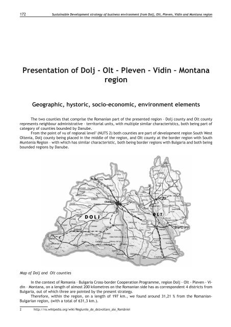
172Sustainable Development strategy of business envi<strong>ro</strong>nment f<strong>ro</strong>m Dolj, Olt, Pleven, Vidin and Montana regionPresentation of Dolj - Olt - Pleven - Vidin – MontanaregionGeographic, hystoric, socio-economic, envi<strong>ro</strong>nment elementsThe two counties that comprise the Romanian part of the presented region – Dolj county and Olt countyrepresents neighbour administrative – territorial units, with multiple similar characteristics, both being part ofcategory of counties boun<st<strong>ro</strong>ng>de</st<strong>ro</strong>ng>d by Danube.F<strong>ro</strong>m the point of vu of regional level 2 (NUTS 2) both counties are part of <st<strong>ro</strong>ng>de</st<strong>ro</strong>ng>velopment region South WestOltenia, Dolj county being placed in the middle of the region, and Olt county at the bor<st<strong>ro</strong>ng>de</st<strong>ro</strong>ng>r region with SouthMuntenia Region – with which has similar characteristic, both being bor<st<strong>ro</strong>ng>de</st<strong>ro</strong>ng>r regions with Bulgaria and both beingboun<st<strong>ro</strong>ng>de</st<strong>ro</strong>ng>d regions by Danube.Map of Dolj and Olt countiesIn the context of Romania – Bulgaria C<strong>ro</strong>ss-bor<st<strong>ro</strong>ng>de</st<strong>ro</strong>ng>r Cooperation P<strong>ro</strong>gramme, region Dolj - Olt - Pleven - Vidin– Montana, on a length of almost 200 kilometres on the Romanian si<st<strong>ro</strong>ng>de</st<strong>ro</strong>ng> has as correspon<st<strong>ro</strong>ng>de</st<strong>ro</strong>ng>nt 4 districts f<strong>ro</strong>mBulgaria, out of which three are pointed by the present strategy.Therefore, within the region, on a length of 197 km., we found a<strong>ro</strong>und 31,21 % f<strong>ro</strong>m the Romanian-Bulgarian region, (with a total of 631,3 km.).2 http://<strong>ro</strong>.wikipedia.org/wiki/Regiunile_<st<strong>ro</strong>ng>de</st<strong>ro</strong>ng>_<st<strong>ro</strong>ng>de</st<strong>ro</strong>ng>zvoltare_ale_României
Sustainable Development strategy of business envi<strong>ro</strong>nment f<strong>ro</strong>m Dolj, Olt, Pleven, Vidin and Montana region 173Placement, Bor<st<strong>ro</strong>ng>de</st<strong>ro</strong>ng>rlandDolj county is situated in the south-south-west area of Romania, between 44°00’ and 44°30’ northlatitu<st<strong>ro</strong>ng>de</st<strong>ro</strong>ng> and 22°00’ and 23°00’ east longitu<st<strong>ro</strong>ng>de</st<strong>ro</strong>ng>, in the area of Getic Plateau, of Romanian Plain and Danubemeadow, and Olt county is c<strong>ro</strong>ssed by the meridian 24 east longitu<st<strong>ro</strong>ng>de</st<strong>ro</strong>ng> and of parallel 44 north latitu<st<strong>ro</strong>ng>de</st<strong>ro</strong>ng>.The region surface is situated on the Romanian si<st<strong>ro</strong>ng>de</st<strong>ro</strong>ng> and has 12.912 km2, out of which 7.414 km2 in Doljcounty and 5.498 km2, in Olt county, representing 5,4 % f<strong>ro</strong>m the total surface of Romaniei (3,1% Dolj, respectively2,3% Olt).Dolj County neighbours with Mehedinti at west, Gorj and Valcea at North, Olt at East and with DanubeRiver at South, on a length of almost 150 km, which constitutes also within a natural bor<st<strong>ro</strong>ng>de</st<strong>ro</strong>ng>r of Romania withBulgaria (Vidin and Montana districts). Olt County has as neighbours Dolj county at West, Valcea at North andArges and Teleorman counties at West. In the South part, as in the Dolj county case, on a length of 47 km, Danuberiver creates a bor<st<strong>ro</strong>ng>de</st<strong>ro</strong>ng>r with Bulgaria - part of Pleven district, component of analysed region.F<strong>ro</strong>m the point of vu of circulation ways, both counties f<strong>ro</strong>m Romania make the liason f<strong>ro</strong>m West to Eastbetween historic p<strong>ro</strong>vinces: Banat and Muntenia, the county capitals being located along important tho<strong>ro</strong>ughfarethat connects Bucuresti - Giurgiu - Alexandria - Craiova – Timisoara – Moravita (E 70), Bors - Ora<st<strong>ro</strong>ng>de</st<strong>ro</strong>ng>a - Deva- Craiova - Calafat (E 79). The territory is c<strong>ro</strong>ssed by network with nume<strong>ro</strong>us national and county <strong>ro</strong>ads: DN 65(Craiova-Slatina-Pitesti). Among these there are nume<strong>ro</strong>us commune <strong>ro</strong>ads that make the connection betweenthe majorities of points f<strong>ro</strong>m the territory belonging to the 2 counties.As regards the rail<strong>ro</strong>ad infrastructure, must be mentioned the rail<strong>ro</strong>ad Bucuresti - Craiova – Timisoara– Moravita or Curtici and also the fact the analysed territory has a good connection on the railway betweenBucuresti-Pitesti-Slatina-Craiova. Another railway <strong>ro</strong>ute that reaches in Olt county is Pitesti-Piatra Olt.The envisaged c<strong>ro</strong>ss-bor<st<strong>ro</strong>ng>de</st<strong>ro</strong>ng>r region by the analysis is characterized th<strong>ro</strong>ugh relevant connections withEu<strong>ro</strong>pean space th<strong>ro</strong>ugh the two Pan-Eu<strong>ro</strong>pean corridors: corridor VII (Danube) and p<strong>ro</strong>ximity of multimodalcorridor IV (Berlin-Nürnberg-Praga-Budapesta-Bucuresti-Constanta-Salonic-Istanbul). To these are ad<st<strong>ro</strong>ng>de</st<strong>ro</strong>ng>d alsothe existence of an international airport in Craiova and the three Danube harbours: Calafat, Bechet and Corabia,representing also bor<st<strong>ro</strong>ng>de</st<strong>ro</strong>ng>r passing points with Bulgaria. The communication network is overlapped overthe analysed territory, along with the existence of bor<st<strong>ro</strong>ng>de</st<strong>ro</strong>ng>r points at the bor<st<strong>ro</strong>ng>de</st<strong>ro</strong>ng>r with Bulgaria, representing thefavourable condition for the economic c<strong>ro</strong>ss-bor<st<strong>ro</strong>ng>de</st<strong>ro</strong>ng>r <st<strong>ro</strong>ng>de</st<strong>ro</strong>ng>velopment.As regards to the Bulgarian si<st<strong>ro</strong>ng>de</st<strong>ro</strong>ng> of the analysed region, Vidin, Montana and Pleven districts are also characterizedth<strong>ro</strong>ugh common characteristics, the most relevant ones being: Danube influence and predominanceof plain relief. The three districts are part of North West <st<strong>ro</strong>ng>de</st<strong>ro</strong>ng>velopment region of Bulgaria. All neighbours in theNorth part with Romania, th<strong>ro</strong>ugh Danube River. Thus, Vidin district neighbours with Serbia in the West part,with Romania at North (th<strong>ro</strong>ugh Mehedinti and Dolj) and with Montana district at East. Montana district hasneighbours Romania (Dolj county) at North and at East Vratsa district. Pleven neighbours at North with Olt andTeleorman counties.The total surface of Bulgarian si<st<strong>ro</strong>ng>de</st<strong>ro</strong>ng> of the analysed region is 11.010 km2.Map of Vidin, Montana and Pleven districtsVidin district has a surface of 3.034 km2, representing a<strong>ro</strong>und 2,7% f<strong>ro</strong>m Bulgaria surface. As anterritorial administrative unit is formed f<strong>ro</strong>m 11 municipalities: Belogradchik, Boynitsa, Bregovo, Vidin,Gramada, Dimovo, Kula, Makresh, Novo Selo, Ruzintsi and Chuprene, with a number of 7 cities amd 135villages.Montana district, with a surface of 3.635.5 km2 is located in the middle of the North West region. Asin the case of Vidin district it neighbours at North with Romania, th<strong>ro</strong>ugh the Danube as a natural bor<st<strong>ro</strong>ng>de</st<strong>ro</strong>ng>r.