Carlisle District Local Plan.indd - Carlisle City Council
Carlisle District Local Plan.indd - Carlisle City Council
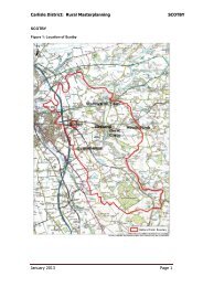
Carlisle District Local Plan.indd - Carlisle City Council

Create successful ePaper yourself
Turn your PDF publications into a flip-book with our unique Google optimized e-Paper software.
<strong>Carlisle</strong> <strong>District</strong> <strong>Local</strong> <strong>Plan</strong> 2001 - 2016 Revised Redeposit draft2.23 Proposals for development will be assessed against a sequential approach in accordancewith PPG/PPS guidance. The approach concentrates development on the <strong>City</strong> Centre as theprime location, followed by edge of centre and the remainder of the urban area. Wherelarge scale development is not feasible within the first two sequential areas, a sustainableurban extension will be considered in order to provide a more efficient use of land andinfrastructure resources.2.24 Outside the urban area Brampton and Longtown have been identified as two key servicecentres. These centres provide the focus for rural service provision. Development will befocused on these centres to help maintain and boost the service development for theircatchment population.2.25 Throughout the remainder of the rural area, development will be focused on a smallnumber of villages to support local services; these are referred to as <strong>Local</strong> Service Centres.These villages already have facilities and could accommodate further development ofan appropriate scale during the <strong>Plan</strong> period. The villages selected in the policy alreadycontain key facilities including a school and/or post office/shop and these are vital to ruralresidents. Development will be focussed on those locations to sustain existing services toenable some journeys to be undertaken without the need for the use of a car.2.26 Settlement boundaries have been defined on the Inset Maps for each of the abovelocations. The settlement boundaries are tightly drawn to limit development and reflect theextent of existing development. They are not intended to reflect land ownership or gardenboundaries and do not restrict permitted development rights were ownership crosses theboundary.POLICY DP2 RegenerationThe <strong>City</strong> <strong>Council</strong> will develop proposals which seek to regenerate the economic,social and environmental capital of the <strong>District</strong>. These proposals will be developed inconjunction with, and will be informed and guided by <strong>Carlisle</strong> Renaissance strategicobjectives.Within the urban area there are four areas where redevelopment/regenerationactivities will be concentrated. These areas are shown on the attached plans.In the Rickergate area a number of city centre uses will be considered based uponretail/commercial/office/hotel and residential development. This is a key site in aprominent location for access to the city from the northIn the Viaduct Estate Road area (Caldew Riverside) proposals will be considered whichoptimise the use of this land, taking account of its setting. A mix of uses would beappropriate including residential, offices and retail.In the Citadel Area there is potential for better utilisation of land and buildings cateringfor additional city centre uses integrated with the existing office and retail mix.In the Raffles area residential development will be the main driver of regenerationsupported by environmental improvements and community facilities.The boundaries of these areas are shown on the proposals map (See extracts).DP2September 2006 19