v bundesamt für kartographie und geodäsie - DGK - Bayerische ...
v bundesamt für kartographie und geodäsie - DGK - Bayerische ...
v bundesamt für kartographie und geodäsie - DGK - Bayerische ...
Erfolgreiche ePaper selbst erstellen
Machen Sie aus Ihren PDF Publikationen ein blätterbares Flipbook mit unserer einzigartigen Google optimierten e-Paper Software.
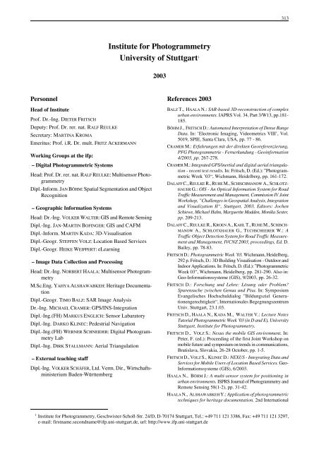
313<br />
Institute for Photogrammetry<br />
University of Stuttgart 1<br />
2003<br />
Personnel<br />
Head of Institute<br />
Prof. Dr.-Ing. DIETER FRITSCH<br />
Deputy: Prof. Dr. rer. nat. RALF REULKE<br />
Secretary: MARTINA KROMA<br />
Emeritus: Prof. i.R. Dr. mult. FRITZ ACKERMANN<br />
Working Groups at the ifp:<br />
– Digital Photogrammetric Systems<br />
Head: Prof. Dr. rer. nat. RALF REULKE: Multisensor Photogrammetry<br />
Dipl.-Inform. JAN BÖHM: Spatial Segmentation and Object<br />
Recognition<br />
– Geographic Information Systems<br />
Head: Dr.-Ing. VOLKER WALTER: GIS and Remote Sensing<br />
Dipl.-Ing. JAN-MARTIN BOFINGER: GIS and CAFM<br />
Dipl.-Inform. MARTIN KADA: 3D-Visualisation<br />
Dipl.-Geogr. STEFFEN VOLZ: Location Based Services<br />
Dipl.-Geogr. HEIKE WEIPPERT: eLearning<br />
– Image Data Collection and Processing<br />
Head: Dr.-Ing. NORBERT HAALA: Multisensor Photogrammetry<br />
M.Sc.Eng. YAHYA ALSHAWABKEH: Heritage Documentation<br />
Dipl.-Geogr. TIMO BALZ: SAR Image Analysis<br />
Dr.-Ing. MICHAEL CRAMER: GPS/INS-Integration<br />
Dipl.-Ing.(FH) MARKUS ENGLICH: Sensor Labaratory<br />
Dipl.-Ing. DARKO KLINEC: Pedestrial Navigation<br />
Dipl.-Ing.(FH) WERNER SCHNEIDER: Digital Photogrammetry<br />
Lab<br />
Dipl.-Ing. DIRK STALLMANN: Aerial Triangulation<br />
– External teaching staff<br />
Dipl.-Ing. VOLKER SCHÄFER, Ltd. Verm. Dir., Wirtschaftsministerium<br />
Baden-Württemberg<br />
References 2003<br />
BALZ T., HAALA N.: SAR-based 3D-reconstruction of complex<br />
urban environments. IAPRS Vol. 34, Part 3/W13, pp.181-<br />
185.<br />
BÖHM J., FRITSCH D.: Automated Interpretation of Dense Range<br />
Data. In: ’Electronic Imaging, Videometrics VIII’, Vol.<br />
5019, SPIE, Santa Clara, USA, pp. 77 - 86.<br />
CRAMER M.: Erfahrungen mit der direkten Georeferenzierung,<br />
PFG Photogrammetrie - Fernerk<strong>und</strong>ung - Geoinformation<br />
4/2003, pp. 267-278.<br />
CRAMER M.: Integrated GPS/inertial and digital aerial triangulation<br />
- recent test results. In: Fritsch, D. (Ed.): ”Photogrammetric<br />
Week ’03“, Wichmann, Heidelberg, pp. 161-172.<br />
DALAFF C., REULKE R., RUHE M., SCHISCHMANOW A., SCHLOTZ-<br />
HAUER G.: OIS - An Optical Information System for Road<br />
Traffic Measurement and Management, Commission IV Joint<br />
Workshop, ”Challenges in Geospatial Analysis, Integration<br />
and Visualization II“, Stuttgart, 2003, Editors: Jochen<br />
Schiewe, Michael Hahn, Marguerite Madden, Monika Sester,<br />
pp. 209-213.<br />
DALAFF C., REULKE R., KROEN A., KAHL T., RUHE M., SCHISCH-<br />
MANOW A., SCHLOTXHAUER G., TUCHSCHEERER W.: A<br />
Traffic Object Detection System for Road Traffic Measurement<br />
and Management, IVCNZ 2003, proceedings, Ed. D.<br />
Bailey, pp. 78-83.<br />
FRITSCH D.: Photogrammetric Week ’03. Wichmann, Heidelberg,<br />
292 p. Fritsch, D.: 3D Building Visualisation - Outdoor and<br />
Indoor Applications. In: Fritsch, D. (Ed.): ”Photogrammetric<br />
Week 03“, Wichmann, Heidelberg, pp. 281-290. Also in:<br />
Geo-Informationssysteme (GIS), 9/2003, pp. 26-32.<br />
FRITSCH D.: Forschung <strong>und</strong> Lehre: Lösung oder Problem?<br />
Spurensuche zwischen Genua <strong>und</strong> Pisa. In: Symposium<br />
Evangelisches Hochschuldialog ”Bildungsziel Generationengerechtigkeit“,<br />
Internationales Begegnungszentrum<br />
Univ. Stuttgart, 23.1.03.<br />
FRITSCH D., HAALA N., KADA M., WALTER V.: Lecture Notes<br />
Tutorial Photogrammetric Week ’03 (in D and E), University<br />
Stuttgart, Institute for Photogrammetry.<br />
FRITSCH D., VOLZ S.: Nexus the mobile GIS environment. In:<br />
Peter, F. (ed.): Proceeding of the first Joint Workshop on<br />
mobile future and symposium on trends in communications,<br />
Bratislava, Slovakia, 26-28 October, pp. 1-5.<br />
FRITSCH D., VOLZ S., KLINEC D.: NEXUS - Integrating Data and<br />
Services for Mobile Users of Location Based Services. Geo-<br />
Informationssysteme (GIS), 6/2003.<br />
HAALA N., BÖHM J.: A multi-sensor system for positioning in<br />
urban environments. ISPRS Journal of Photogrammetry and<br />
Remote Sensing 58(1-2), pp. 31-42.<br />
HAALA N., ALSHAWABKEH Y.: Application of photogrammetric<br />
techniques for heritage documentation. 2nd International<br />
1<br />
Institute for Photogrammetry, Geschwister-Scholl-Str. 24/D, D-70174 Stuttgart, Tel.: +49 711 121 3386, Fax: +49 711 121 3297,<br />
e-mail: firstname.secondname@ifp.uni-stuttgart.de, url: http://www.ifp.uni-stuttgart.de


