- Page 1:
TISCIA monograph series The Upper T
- Page 4 and 5:
TISCIA monograph series 1. J. Hamar
- Page 6 and 7:
The Upper Tisa Valley Preparatory p
- Page 9 and 10:
Foreword The basic obligations of t
- Page 11:
The Upper Tisa Valley Preparatory p
- Page 15 and 16:
Date: September 28, 1998 Country: U
- Page 17 and 18:
River Chorna Tisa rises in the nort
- Page 19 and 20:
formed here, which, along with the
- Page 21 and 22:
«Radyansky Karpaty» - a forest re
- Page 23:
- the Carpathian Biosphere Reserve
- Page 26 and 27:
Aspleniaceae Asplenium adiantum-nig
- Page 28 and 29:
S. fluviatilis Wallb. S. fuchsii Gm
- Page 30 and 31:
Phyteuma orbiculare l. Ph. spicatum
- Page 32 and 33:
E. intersita Zinserl. E. palustris
- Page 34 and 35:
Huperzia selago (L.) Bernh. ex Schr
- Page 36 and 37:
Marsileaceae Marsilea quadrifolia L
- Page 38 and 39:
Phleum alpinum L. Ph. hirsutum Honc
- Page 40 and 41:
A. subcrenata Bus. A. szaferi Pawl.
- Page 42 and 43:
Rh. serotinus (Schoenh.) Oborny Rh.
- Page 44 and 45:
Epilobietalia fleischeri Moor 58 Ep
- Page 46 and 47:
Caricion gracilis Neuhäusl 59 em.
- Page 48 and 49:
Alysso-Sedetalia Moravec 67 Alysso
- Page 50 and 51:
Piceetalia excelsae Pawłowski in P
- Page 52 and 53:
are mainly useful, since they consu
- Page 54 and 55:
52 area, categorized as oligothroph
- Page 56 and 57:
Physical features: within the bound
- Page 59 and 60:
The depth of River Tisa is 1.8 - 2.
- Page 61 and 62:
forests. Today these forests are in
- Page 63 and 64:
As to the fishes, 33 species have b
- Page 65 and 66:
Lasting until the end of December t
- Page 67 and 68:
Works of consolidation were no long
- Page 69 and 70:
- Scientists (researchers, museum s
- Page 71 and 72:
-the mayoralties of Remeţi, Săpâ
- Page 73 and 74:
Appendix List of Vertebrates Confir
- Page 75 and 76:
Columba palumbus palumbus (L.) 1758
- Page 77 and 78:
Calidris minuta (Leisl.) 1812 - Lit
- Page 79 and 80:
Chart 8. Ligneous Plants from the U
- Page 81 and 82:
Date: September 23, 1996 Country: U
- Page 83 and 84:
Down from the town of Hust River Ti
- Page 85 and 86:
island forests and basins attached
- Page 87 and 88:
of that flood. A furniture factory
- Page 89 and 90:
programme, in accordance with which
- Page 91 and 92:
Krocsko Gy. - Krocsko L.: Leafy for
- Page 93 and 94:
Pisces Acipenseridae Salmonidae Thy
- Page 95 and 96:
A. albifrons Scop. Pica pica L. A.
- Page 97 and 98:
Conservation measures Characteristi
- Page 99:
Carpathians’ fauna: its present s
- Page 102 and 103:
Physical features: The site is a ba
- Page 104 and 105:
102 Agriculture, mainly with fast-g
- Page 107 and 108:
Date: October 20, 1996 Country: Hun
- Page 109 and 110:
Salix eleagnos Iris pseudacorus Leu
- Page 111:
Current scientific research and fac
- Page 114 and 115:
112 represented by subcontinental c
- Page 116 and 117:
Current recreation and tourism: The
- Page 118 and 119:
116 The amount of yearly precipitat
- Page 120 and 121: 118 References: BOGOLY, J.: Király
- Page 122 and 123: 120 incision characteristics, with
- Page 124 and 125: 122 Agriculture, mainly with fast-g
- Page 127: The Upper Tisa Valley Ecological ba
- Page 130 and 131: 128 Figure 1
- Page 132 and 133: Site 3 Situated on River Bila Tisa,
- Page 134 and 135: Table 1. Median grain size of sedim
- Page 137 and 138: Hydrogeographical features of the U
- Page 139 and 140: Figure 2 A schematic geological map
- Page 141 and 142: Basin filled with Tertiary layers.
- Page 143 and 144: their mass is concerned, because th
- Page 145 and 146: Figure 6. Schematic valley length s
- Page 147 and 148: Figure 8. Distribution of precipita
- Page 149 and 150: Figure 10 Annual mean values of pre
- Page 151 and 152: Figure 12 Monthly mean values of pr
- Page 153 and 154: turn, may cause inestimable floodin
- Page 155 and 156: Figure 14. A map of the density of
- Page 157 and 158: Figure 15 The catchment area of Riv
- Page 159 and 160: Figure 16 Terraces of the mountain-
- Page 161 and 162: Anyhow, terraces are important comp
- Page 163 and 164: Figure 17 A schematic delineation o
- Page 165 and 166: high hilly region. Its rock composi
- Page 167 and 168: Figure 18 Changes of the beds of Ri
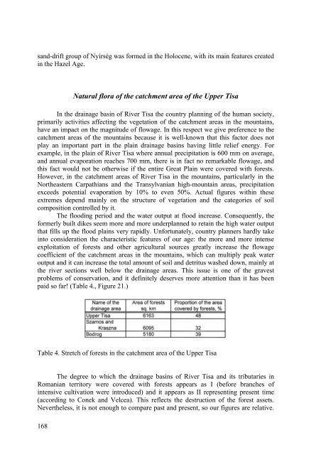
- Page 169: Figure 20. Average potential evapot
- Page 173 and 174: The floristic distribution of the v
- Page 175 and 176: Reconstruction of flora, soil and l
- Page 177 and 178: Fig.1. The geographical region with
- Page 179 and 180: The climate in this region has a st
- Page 181 and 182: Fig.6. Location of coring site, Csa
- Page 183 and 184: The next sediment layer is 298-234
- Page 185 and 186: Fig.7B. Physical characteristics an
- Page 187 and 188: other hand the low Sr:Ba ratio indi
- Page 189 and 190: after approximately 9200 BP. The sp
- Page 191 and 192: Radiocarbon analysis Four evenly sp
- Page 193 and 194: Fig.9. Percentage pollen and charco
- Page 195 and 196: Fig.10. Archaeological findspots ar
- Page 197 and 198: Fig.11. Archaeological findspots ar
- Page 199 and 200: Fig.12. Fig.10. Archaeological find
- Page 201 and 202: Quercus/Ulmus/Corylus/Tilia/Fraxinu
- Page 203 and 204: Edwards, K.J. 1982: Man, space and
- Page 205 and 206: Sherratt, A. 1982a: The development
- Page 207 and 208: Appeal to the participants of the S
- Page 209 and 210: Conception for the regeneration of
- Page 211 and 212: Grounds for Application The crisis-
- Page 213: Table 2. Carpathian Forest Research
- Page 216 and 217: from the Carpathian Biosphere Reser
- Page 218 and 219: Tisa, especially in the dead branch
- Page 220 and 221:
Marsileaceae 7. Marsilea quadrifoli
- Page 222 and 223:
61. Saxifraga stellaris L.; BT (32)
- Page 224 and 225:
114. Andromeda polifolia L.;CT (!);
- Page 226 and 227:
158. Sambucus ebulus L.;UT (11); H,
- Page 228 and 229:
210. Iris sibirica L.; UT (28,32);
- Page 230 and 231:
266. Carex davalliana Sm.; BT (32,!
- Page 232 and 233:
Isoëto-nanojuncetea Br. -Bl. et Tx
- Page 234 and 235:
68. Frangulo-Salicetum cinereae Mal
- Page 236 and 237:
(P. 8.) Equisetum arvense L. 1753,
- Page 238 and 239:
(50) Ranunculus sardous Cr. 1763, H
- Page 240 and 241:
(231) Rosa afzeliana = dumalis Bech
- Page 242 and 243:
(395) Lathyrus tuberosus L. 1753, H
- Page 244 and 245:
(463) Parthenocissus inserta (Kern.
- Page 246 and 247:
(573) Galium mollugo L. 1753 et. G.
- Page 248 and 249:
Callitrichaceae (686) Callitriche p
- Page 250 and 251:
(784) Prunella vulgaris L. 1753, HT
- Page 252 and 253:
(894) Veronica prostrata L. 1753, H
- Page 254 and 255:
(1079) Rorippa X astylis (Rchb. 183
- Page 256 and 257:
(1222) Pulicaria dysenterica (L. 17
- Page 258 and 259:
(1385) Mycelis muralis (L. 1753 sub
- Page 260 and 261:
(1544) Chenopodium strictum Roth 18
- Page 262 and 263:
260 Salicetum triandrae, Glycyrrhiz
- Page 264 and 265:
(1730) Allium oleraceum L. 1753, HT
- Page 266 and 267:
(1903) Carex praecox Schreb. 1771,
- Page 268 and 269:
ass., Bidentetea, Echinochloo-Polyg
- Page 270 and 271:
- Lemno-spirodeletum W. Koch 1954,
- Page 272 and 273:
- Rudbeckio-Solidaginetum Tx. et Ra
- Page 274 and 275:
Simon, T. (1952): Montán elemek az
- Page 276 and 277:
etc.), H. Zapalowicz (1889; etc.),
- Page 278 and 279:
Figure1. Map of studied area 276 Re
- Page 280 and 281:
Alps. This index is twice as low fo
- Page 282 and 283:
B. virginianum (B. virginianum subs
- Page 284 and 285:
F.drymeja (F. montana) - RRL (IV) F
- Page 286 and 287:
Myricaria germanica (Tamarix german
- Page 288 and 289:
S. hispanicum (S. glaucum) - RRL (I
- Page 290 and 291:
Salicetum retuso-reticulatae Br.-Bl
- Page 292 and 293:
Domin, K. (1929 -1931): Schedae ad
- Page 294 and 295:
Stojko, S.- Hadaè, E.- Simon, T.-
- Page 296 and 297:
side tributaries of River Tisa (spe
- Page 298 and 299:
forests and all along the riverbed
- Page 300 and 301:
Porphyrellus pseudoscaber (Secr.) S
- Page 302 and 303:
mushrooms of the Upper Lăpuş) - T
- Page 304 and 305:
302
- Page 306 and 307:
304
- Page 308 and 309:
306
- Page 311 and 312:
Water developments and their impact
- Page 313 and 314:
Solovka and elsewhere with over 40
- Page 315 and 316:
ing dyke. Further flood defences ar
- Page 317 and 318:
Figure 3. The Tur/Túr catchment, f
- Page 319 and 320:
The impacts of the Călineşti Oaş
- Page 321 and 322:
Figure 5. The Crasna/Kraszna catchm
- Page 323 and 324:
Reservoirs Following the large floo
- Page 325 and 326:
Figure 7. Increase of the annual mi
- Page 327 and 328:
Climate and hydrology are influence
- Page 329 and 330:
long and 23 m high consists of a 11
- Page 331 and 332:
the ratio of the monthly highest an
- Page 333 and 334:
Groundwaters From the viewpoint of
- Page 335 and 336:
e wider than 100 fold (Figure 12.).
- Page 337 and 338:
water. The levels of total nitrogen
- Page 339 and 340:
the 1993 December flood on the Uppe
- Page 341 and 342:
Chemical water quality of the upper
- Page 343 and 344:
General features Results and evalua
- Page 345 and 346:
Figure 7. Concentrations of differe
- Page 347 and 348:
Figure 10. Iron and manganese conce
- Page 349 and 350:
Table 2. Besides aluminium and merc
- Page 351 and 352:
Hygienic bacteriological valuation
- Page 353 and 354:
Table 2. Results of the bacteriolog
- Page 355:
References Csépai F.(1995): Data o
- Page 358 and 359:
356 Material and methods Samples we
- Page 360 and 361:
358 References Ádámosi et al. (19
- Page 362 and 363:
Table 1. continued 360
- Page 364 and 365:
During the summer and autumn journe
- Page 366 and 367:
Hungarian area of River Tisa 80 spe
- Page 368 and 369:
Table 3. Average hydrobiological pa
- Page 370 and 371:
Table 5. Average hydrobiological pa
- Page 372 and 373:
It is necessary to note that it is
- Page 374 and 375:
Table 7. Saprobiological characteri
- Page 376 and 377:
In practice, results of classificat
- Page 378 and 379:
conservation of the Carpathians bio
- Page 380 and 381:
Table 1. continue 378
- Page 382 and 383:
Table 1. continue 380
- Page 384 and 385:
Table 1. continue 382 Notes: Pl - p
- Page 386 and 387:
with stagnant water, which were ass
- Page 388 and 389:
Monchenko V.I. (1983): Noviye dlia
- Page 390 and 391:
Table continue 388
- Page 392 and 393:
Table continue 390
- Page 395 and 396:
Zooplankton investigations in the U
- Page 397 and 398:
Fig. 1. Number of Rotatoria species
- Page 399 and 400:
References Bancsi I. 1986.: A kerek
- Page 401:
Table 1. continue 399
- Page 404 and 405:
402 Figure 1. Sampling places
- Page 406 and 407:
Table 1. continue 404
- Page 408 and 409:
The species richness of chironomids
- Page 411 and 412:
A study of aquatic molluscs in the
- Page 413 and 414:
Table 1. Distribution of mollusc sp
- Page 415 and 416:
Some considerations about the rheop
- Page 417 and 418:
The main types of benthic associati
- Page 419 and 420:
The high flood of the waters in the
- Page 421 and 422:
References Barbosa, F.A.R., Găldea
- Page 423 and 424:
421
- Page 425 and 426:
423
- Page 427:
Table 1. continue 425
- Page 430 and 431:
1998). Besides, Ujhelyi (1971) also
- Page 432 and 433:
Table 1. (B) Synopsis of the Tricho
- Page 434 and 435:
432 1. Distribution of some species
- Page 436 and 437:
Figure 3. Activity graph of six cad
- Page 438 and 439:
436 3. Transformation of Trichopter
- Page 441 and 442:
Fish fauna of the Upper Tisa Ákos
- Page 443 and 444:
Fam. Acipenseridae 2. Ship Acipense
- Page 445 and 446:
We observed this species downstream
- Page 447 and 448:
Fam. Siluridae 43. Sheatfish Siluru
- Page 449 and 450:
57. Ruffe Gymnocephalus cernuus (Li
- Page 451 and 452:
In addition to zonation, another si
- Page 453 and 454:
River Danube which is probaly why t
- Page 455 and 456:
Table: Fishes of the Upper Tisa 453
- Page 457 and 458:
Data to the fish fauna of River Tis
- Page 459 and 460:
were put back to the water after id
- Page 461 and 462:
600. - Tisza-Gravel-pit pond (Milot
- Page 463 and 464:
Szamos (Vásárosnamény): 05.07.19
- Page 465 and 466:
31. Pseudorasbora parva Schlegel, 1
- Page 467 and 468:
46. Salmo trutta m. fario Linnaeus,
- Page 469 and 470:
56. Zingel zingel Linnaeus, 1758 Sz
- Page 471 and 472:
Dévai, Gy., Miskolczi, M., Tóth,
- Page 473 and 474:
Biogeographical characterisation of
- Page 475 and 476:
in the lack of sufficient data abou
- Page 477 and 478:
on the flood plain. In Bagiszeg Per
- Page 479:
References Bába K. (1969): Die Mal
- Page 482 and 483:
480 Carychium minimum (Müller, 177
- Page 484 and 485:
Thus, based on staying vs. migratin
- Page 486 and 487:
484 Table1. Species composition and
- Page 488 and 489:
486 Table 1. continue
- Page 491 and 492:
Vertebrates of the Subcarpathian se
- Page 493 and 494:
are active from March to November.
- Page 495 and 496:
Mammals/Mammalia Insectivores/Insec
- Page 497 and 498:
are active at nightfall and at nigh
- Page 499 and 500:
Artiodactyla. The roebuck sheds its
- Page 501 and 502:
newly planted forests and nurseries
- Page 503 and 504:
Contents Preface...................


