Using ArcCatalog
Using ArcCatalog
Using ArcCatalog

Create successful ePaper yourself
Turn your PDF publications into a flip-book with our unique Google optimized e-Paper software.
Preparing<br />
metadata for<br />
publication<br />
Before you can publish<br />
metadata you need to define the<br />
pieces of information that are<br />
required by the Metadata<br />
Service: title, publisher, spatial<br />
extent, theme, and content type.<br />
Either the FGDC or ISO<br />
metadata editor, or both, may be<br />
used to do so.<br />
With the FGDC editor you must<br />
type in the theme and content<br />
type codes. The FGDC editor<br />
lets you define any number of<br />
theme keywords—the requirement<br />
is for at least one keyword<br />
to come from the Metadata<br />
Service’s list. For example, a<br />
soils dataset might have the<br />
existing keywords: soil, clay,<br />
and corn. To publish the<br />
dataset’s metadata, add the<br />
theme code farming to that list.<br />
If you want to keep the theme<br />
code separate from the existing<br />
set of keywords, add a new<br />
group of keywords and define<br />
that group’s thesaurus as<br />
Metadata Service Theme<br />
Categories. Alternatively, leave<br />
your FGDC theme keywords list<br />
the way it is, and use the ISO<br />
editor to define the theme code.<br />
Similarly, when defining the<br />
content type code, the FGDC u<br />
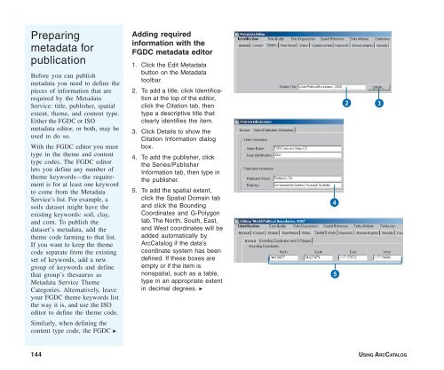
Adding required<br />
information with the<br />
FGDC metadata editor<br />
1. Click the Edit Metadata<br />
button on the Metadata<br />
toolbar.<br />
2. To add a title, click Identification<br />
at the top of the editor,<br />
click the Citation tab, then<br />
type a descriptive title that<br />
clearly identifies the item.<br />
3. Click Details to show the<br />
Citation Information dialog<br />
box.<br />
4. To add the publisher, click<br />
the Series/Publisher<br />
Information tab, then type in<br />
the publisher.<br />
5. To add the spatial extent,<br />
click the Spatial Domain tab<br />
and click the Bounding<br />
Coordinates and G-Polygon<br />
tab. The North, South, East,<br />
and West coordinates will be<br />
added automatically by<br />
<strong>ArcCatalog</strong> if the data’s<br />
coordinate system has been<br />
defined. If these boxes are<br />
empty or if the item is<br />
nonspatial, such as a table,<br />
type in an appropriate extent<br />
in decimal degrees. u<br />
4<br />
5<br />
2<br />
3<br />
144 USING ARCCATALOG