Using ArcCatalog
Using ArcCatalog
Using ArcCatalog

You also want an ePaper? Increase the reach of your titles
YUMPU automatically turns print PDFs into web optimized ePapers that Google loves.
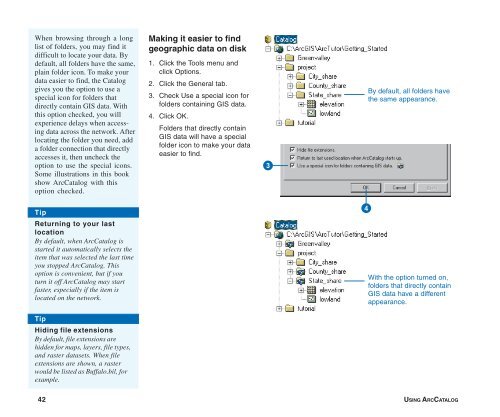
When browsing through a long<br />
list of folders, you may find it<br />
difficult to locate your data. By<br />
default, all folders have the same,<br />
plain folder icon. To make your<br />
data easier to find, the Catalog<br />
gives you the option to use a<br />
special icon for folders that<br />
directly contain GIS data. With<br />
this option checked, you will<br />
experience delays when accessing<br />
data across the network. After<br />
locating the folder you need, add<br />
a folder connection that directly<br />
accesses it, then uncheck the<br />
option to use the special icons.<br />
Some illustrations in this book<br />
show <strong>ArcCatalog</strong> with this<br />
option checked.<br />
Making it easier to find<br />
geographic data on disk<br />
1. Click the Tools menu and<br />
click Options.<br />
2. Click the General tab.<br />
3. Check Use a special icon for<br />
folders containing GIS data.<br />
4. Click OK.<br />
Folders that directly contain<br />
GIS data will have a special<br />
folder icon to make your data<br />
easier to find.<br />
3<br />
By default, all folders have<br />
the same appearance.<br />
Tip<br />
Returning to your last<br />
location<br />
By default, when <strong>ArcCatalog</strong> is<br />
started it automatically selects the<br />
item that was selected the last time<br />
you stopped <strong>ArcCatalog</strong>. This<br />
option is convenient, but if you<br />
turn it off <strong>ArcCatalog</strong> may start<br />
faster, especially if the item is<br />
located on the network.<br />
4<br />
With the option turned on,<br />
folders that directly contain<br />
GIS data have a different<br />
appearance.<br />
Tip<br />
Hiding file extensions<br />
By default, file extensions are<br />
hidden for maps, layers, file types,<br />
and raster datasets. When file<br />
extensions are shown, a raster<br />
would be listed as Buffalo.bil, for<br />
example.<br />
42 USING ARCCATALOG