Using ArcCatalog
Using ArcCatalog
Using ArcCatalog

Create successful ePaper yourself
Turn your PDF publications into a flip-book with our unique Google optimized e-Paper software.
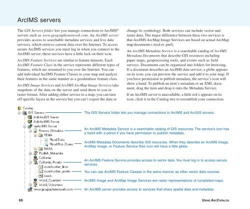
ArcIMS servers<br />
The GIS Servers folder lets you manage connections to ArcIMS ®<br />
servers such as www.geographynetwork.com. An ArcIMS server<br />
provides access to searchable metadata services and live data<br />
services, which retrieve current data over the Internet. To access<br />
secure ArcIMS services you must log in when you connect to the<br />
ArcIMS server; these services have a little lock on their icon.<br />
ArcIMS Feature Services are similar to feature datasets. Each<br />
ArcIMS Feature Class in the service represents different types of<br />
features, which are streamed to you over the Internet. You can<br />
add individual ArcIMS Feature Classes to your map and analyze<br />
their features in the same manner as a geodatabase feature class.<br />
ArcIMS Image Services and ArcIMS ArcMap Image Services take<br />
snapshots of the data on the server and send them to you in<br />
raster format. After adding either service to a map, you can turn<br />
off specific layers in the service but you can’t export the data or<br />
change its symbology. Both services can include vector and<br />
raster data. The major difference between these two services is<br />
that ArcIMS ArcMap Image Services are based on actual ArcMap<br />
map documents (.mxd or .pmf).<br />
An ArcIMS Metadata Service is a searchable catalog of ArcIMS<br />
Metadata Documents that describe GIS resources including<br />
paper maps, geoprocessing tools, and events such as field<br />
surveys. Documents can be organized into folders for browsing.<br />
If a document describes an ArcIMS data service, a globe appears<br />
on its icon; you can preview the service and add it to your map. If<br />
you have permission to publish metadata, the service’s icon will<br />
show a hand. To publish an item’s metadata or an XML document,<br />
drag the item and drop it onto the Metadata Service.<br />
If an ArcIMS server is unavailable, a little red x appears on its<br />
icon; click it in the Catalog tree to reestablish your connection.<br />
The GIS Servers folder lets you manage connections to ArcIMS and ArcGIS servers.<br />
An ArcIMS Metadata Service is a searchable catalog of GIS resources. The service’s icon has<br />
a hand with a pencil if you have permission to publish metadata.<br />
ArcIMS Metadata Documents describe GIS resources. When they describe an ArcIMS Image,<br />
ArcMap Image, or Feature Service their icon will have a little globe.<br />
An ArcIMS Feature Service provides access to vector data. You must log in to access secure<br />
services.<br />
You can use ArcIMS Feature Classes in the same manner as other vector data sources.<br />
ArcIMS Image and ArcMap Image Services are raster representations of completed maps.<br />
An ArcIMS server provides access to services that share spatial data and metadata.<br />
66 USING ARCCATALOG