Using ArcCatalog
Using ArcCatalog
Using ArcCatalog

You also want an ePaper? Increase the reach of your titles
YUMPU automatically turns print PDFs into web optimized ePapers that Google loves.
CAD drawings<br />
You can access CAD drawings directly in <strong>ArcCatalog</strong>. CAD<br />
drawings typically have many layers, each of which represents a<br />
different type of geographic feature. For example, the drawing<br />
might contain different line layers for streets, water mains, and<br />
parcel boundaries. Other layers in the drawing may represent<br />
geographic features with points or polygons or contain annotation<br />
for labeling the features.<br />
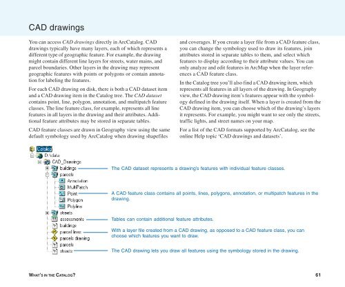
For each CAD drawing on disk, there is both a CAD dataset item<br />
and a CAD drawing item in the Catalog tree. The CAD dataset<br />
contains point, line, polygon, annotation, and multipatch feature<br />
classes. The line feature class, for example, represents all line<br />
features in all layers in the drawing and their attributes. Additional<br />
feature attributes may be stored in separate tables.<br />
CAD feature classes are drawn in Geography view using the same<br />
default symbology used by <strong>ArcCatalog</strong> when drawing shapefiles<br />
and coverages. If you create a layer file from a CAD feature class,<br />
you can change the symbology used to draw its features, join<br />
attributes stored in separate tables to them, and select which<br />
features to display according to their attribute values. You can<br />
only analyze and edit features in ArcMap when the layer references<br />
a CAD feature class.<br />
In the Catalog tree you’ll also find a CAD drawing item, which<br />
represents all features in all layers of the drawing. In Geography<br />
view, the CAD drawing item’s features appear with the symbology<br />
defined in the drawing itself. When a layer is created from the<br />
CAD drawing item, you can choose which of the drawing’s layers<br />
it represents. For example, you might want to see only the streets,<br />
traffic lights, and street names on your map.<br />
For a list of the CAD formats supported by <strong>ArcCatalog</strong>, see the<br />
online Help topic ‘CAD drawings and datasets’.<br />
The CAD dataset represents a drawing’s features with individual feature classes.<br />
A CAD feature class contains all points, lines, polygons, annotation, or multipatch features in the<br />
drawing.<br />
Tables can contain additional feature attributes.<br />
With a layer file created from a CAD drawing, as opposed to a CAD feature class, you can<br />
choose which features you want to draw.<br />
The CAD drawing lets you draw all features using the symbology stored in the drawing.<br />
WHAT’S IN THE CATALOG? 61