Using ArcCatalog
Using ArcCatalog
Using ArcCatalog

You also want an ePaper? Increase the reach of your titles
YUMPU automatically turns print PDFs into web optimized ePapers that Google loves.
Defining a<br />
shapefile’s<br />
coordinate<br />
system<br />
A shapefile often doesn’t have<br />
any information defining which<br />
coordinate system was used to<br />
define its features. In this case,<br />
the Shape column’s Spatial<br />
Reference property will be<br />
unknown or assumed geographic.<br />
If the features’ bounding<br />
coordinates are within the<br />
range of -180 and 180 in the x<br />
direction and -90 and 90 in the y<br />
direction, ArcGIS software<br />
assumes the data to be geographic<br />
and its datum to be<br />
NAD27. You can work with<br />
shapefiles even if their coordinate<br />
system hasn’t been<br />
defined, but you may not be<br />
able to take advantage of all the<br />
available functionality. For<br />
example, you may be unable to<br />
add the shapefile to some maps,<br />
and its automatically created<br />
metadata will be incomplete.<br />
You can define a shapefile’s<br />
coordinate system in<br />
<strong>ArcCatalog</strong> in several ways.<br />
You can select one of the<br />
predefined coordinate systems<br />
provided with <strong>ArcCatalog</strong>,<br />
import the coordinate system<br />
parameters used by another<br />
data source, or define a new, u<br />
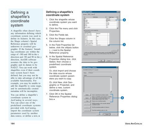
Defining a shapefile’s<br />
coordinate system<br />
1. Click the shapefile whose<br />
coordinate system you want<br />
to define.<br />
2. Click the File menu and click<br />
Properties.<br />
3. Click the Fields tab.<br />
4. Click the Shape column in<br />
the column list.<br />
5. In the Field Properties list<br />
below, click the ellipsis button<br />
(...) next to the Spatial<br />
Reference property.<br />
6. In the Spatial Reference<br />
Properties dialog box, click<br />
Select, then choose a<br />
predefined coordinate<br />
system.<br />
Or, click Import and choose<br />
the data source whose<br />
coordinate system parameters<br />
you want to copy.<br />
Or, click New, click Geographic<br />
or Projected, and<br />
define a new, custom<br />
coordinate system.<br />
7. Click OK in the Spatial<br />
Reference Properties dialog<br />
box. u<br />
4<br />
5<br />
6<br />
7<br />
184 USING ARCCATALOG