Using ArcCatalog
Using ArcCatalog
Using ArcCatalog

Create successful ePaper yourself
Turn your PDF publications into a flip-book with our unique Google optimized e-Paper software.
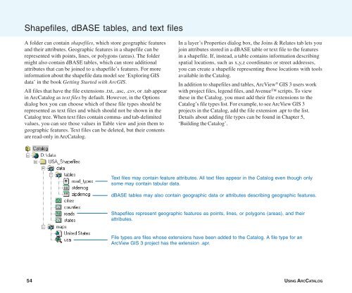
Shapefiles, dBASE tables, and text files<br />
A folder can contain shapefiles, which store geographic features<br />
and their attributes. Geographic features in a shapefile can be<br />
represented with points, lines, or polygons (areas). The folder<br />
might also contain dBASE tables, which can store additional<br />
attributes that can be joined to a shapefile’s features. For more<br />
information about the shapefile data model see ‘Exploring GIS<br />
data’ in the book Getting Started with ArcGIS.<br />
All files that have the file extensions .txt, .asc, .csv, or .tab appear<br />
in <strong>ArcCatalog</strong> as text files by default. However, in the Options<br />
dialog box you can choose which of these file types should be<br />
represented as text files and which should not be shown in the<br />
Catalog tree. When text files contain comma- and tab-delimited<br />
values, you can see those values in Table view and join them to<br />
geographic features. Text files can be deleted, but their contents<br />
are read-only in <strong>ArcCatalog</strong>.<br />
In a layer’s Properties dialog box, the Joins & Relates tab lets you<br />
join attributes stored in a dBASE table or text file to the features<br />
in a shapefile. If, instead, a table contains information describing<br />
spatial locations, such as x,y,z coordinates or street addresses,<br />
you can create a shapefile representing those locations with tools<br />
available in the Catalog.<br />
In addition to shapefiles and tables, ArcView ® GIS 3 users work<br />
with project files, legend files, and Avenue scripts. To view<br />
these in the Catalog, you must add their file extensions to the<br />
Catalog’s file types list. For example, to see ArcView GIS 3<br />
projects in the Catalog, add the file extension .apr to the list.<br />
Details about adding file types can be found in Chapter 5,<br />
‘Building the Catalog’.<br />
Text files may contain feature attributes. All text files appear in the Catalog even though only<br />
some may contain tabular data.<br />
dBASE tables may also contain geographic data or attributes describing geographic features.<br />
Shapefiles represent geographic features as points, lines, or polygons (areas), and their<br />
attributes.<br />
File types are files whose extensions have been added to the Catalog. A file type for an<br />
ArcView GIS 3 project has the extension .apr.<br />
54 USING ARCCATALOG